Baraigram Upazila
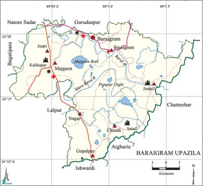
Baraigram Upazila (natore district) area 299.60 sq km, located in between 24°10' and 24°21' north latitudes and in between 88°01' and 89°17' east longitudes. It is bounded by gurudaspur and natore sadar upazilas on the north, atgharia and ishwardi upazilas on the south, chatmohar upazila on the east, lalpur and bagatipara upazilas on the west.
Population Total 279672; male 138746, female 140926; Muslim 262512, Hindu 10565, Christian 6154 and others 441. Indigenous communities such as Pahari, Munda, Oraon, Mahato belong to this upazila.
Water bodies Main rivers: baral, Nandakuja, Khalsadanga and Mara Baral; Majgaon beel and Pangiar dighi are notable.
Administration Baraigram Thana was formed in 1869 and it was turned into an upazila in 1983.
| Upazila | ||||||||
| Municipality | Union | Mouza | Village | Population | Density (per sq km) | Literacy rate (%) | ||
| Urban | Rural | Urban | Rural | |||||
| 2 | 7 | 141 | 169 | 39523 | 240149 | 933 | 59.1 | 48.5 |
| Baraigram Municipality | ||||||||
| Area (sq km) |
Ward | Mahalla | Population | Density (per sq km) |
Literacy rate (%) | |||
| - | 9 | 11 | 22247 | - | 61.6 | |||
| Banpara Municipality | ||||||||
| Area (sq km) |
Ward | Mahalla | Population | Density (per sq km) |
Literacy rate (%) | |||
| - | 9 | 17 | 17276 | - | 54.3 | |||
| Union | ||||
| Name of union and GO code | Area (acre) | Population | Literacy rate (%) | |
| Male | Female | |||
| Gopalpur 35 | 7038 | 13057 | 13305 | 51.7 |
| Chandi 23 | 8142 | 11051 | 11193 | 44.9 |
| Jonail 59 | 9790 | 17103 | 17748 | 47.4 |
| Joari 47 | 9338 | 19525 | 20138 | 59.0 |
| Nagar 83 | 12732 | 21262 | 20913 | 44.5 |
| Baraigram 11 | 11018 | 18912 | 18868 | 44.4 |
| Majgaon 71 | 10150 | 18280 | 18794 | 46.7 |
Source Bangladesh Population Census 2011, Bangladesh Bureau of Statistics.

Archaeological heritage and relics Ancient copper plate in Nagar Union (415-455), ancient statue of Parnasharbari, Mughal fort, Kali Mandir (temple), Durga Mandir and Shiva Mandir (BS. 1212) in Joari Union, ancient Joykali Mandir at Haroa, ancient mosque (Nawabi period) at Ahmadpur, old Zaminder Bari and Shiva Mandir in Baraigram Union, Dargah of Sona Pir at Noabari, Santoil palace in Chandi Union, old Gunaihati Mosque and French stone inscription in Majgaon Union.
War of Liberation During the war of liberation the Pak army brutally killed 85 innocent persons of Banpara Mission Refugee Camp on 3 May 1971. Freedom fighters had encounters with Pak army at Majhpara and Mashinda of the upazila. There is a mass grave in the upazila, a martyr memorial was built.
For details: see বড়াইগ্রাম উপজেলা, বাংলাদেশ মুক্তিযুদ্ধ জ্ঞানকোষ (Encyclopedia of Bangladesh War of Liberation), বাংলাদেশ এশিয়াটিক সোসাইটি, ঢাকা ২০২০, খণ্ড ৬।
Religious institutions Mosque 274, temple 8, church 4.
Literacy rate and educational institutions Average literacy 50.0%; male 51.6%, female 48.5%. Educational institutions: college 18, secondary school 45, technical school and college 5, educational centre of open university 4, primary school 81, madrasa 43. Noted educational institutions: Baraigram Degree College (1970), Banpara Degree College (1985), Rajapur Degree College (1995), Moukhara Mahila Degree College (1996), Banpara Agricultural and Technical College (2000), Baraigram Pilot High School (1954), Rajapur High School (1954), St. Louis High School (1959), St. Joseph High School (1963), Ahmadpur MH High School (1985), Dasgram Siddikiya Alia Madrasa (1945), Dhanaidha Fazil Madrasa (1957).
Cultural organisations Library 2, press club 1, club 53, cinema hall 3.
Tourist spots 150 acre Dighi (Atrai), Mughal Fort (Joari), Santoil Palace (Chandi), Banpara Mission (1930), Borni Roman Catholic Mission (1949).'
Main sources of income Agriculture 73.70%, non-agricultural labourer 2.72%, commerce 9.31%, transport and communication 3.58%, industry 1.03%, service 4.40%, construction 0.72%, religious service 0.13%, rent and remittance 0.32% and others 4.09%.
Ownership of agricultural land Landowner 57.72%, landless 42.28%; agricultural landowner: urban 46.43% and rural 58.60%.
Main crops Paddy, sugarcane, wheat, mustard seed, turmeric, vegetables.
Extinct or nearly extinct crops Sweet potato, kaun, barley, peanut.
Main fruits Mango, jackfruit, litchi, banana, papaya, guava.
Fisheries, dairies and poultries Fishery 2, hatchery 7.'
Communication facilities Roads: pucca road 148 km, semi-pucca road 26 km, mud road 442 km.
Extinct or nearly extinct traditional transport Palanquin, bullock cart, buffalo cart, horse carriage.
Noted manufactories Ice factory, rice mill.
Cottage industries Goldsmith, silversmith, blacksmith, potteries, weaving, nakshi kantha, bamboo work, cane work, woodworks.
Hats, bazars and fairs Hats and bazars are 18, fairs 7, most noted of which are Moukhara Bazar, Banpara Bazar, Marrygachha Hat, Rajapur Hat, Janitala Baruni and Gangaschan Mela, Laksmikol Charak and Dashami Mela, Nagar and Dhanaidah Chaitra Sangkranti Charak Mela, Darikushi and Jonail Paush Mela and Banpara Bhaishakhi Mela.
Main exports Paddy, banana, papaya, date molasses.
Access to electricity All the unions of the upazila are under rural electrification net-work. However 43.7% dwellings have access to electricity.
Sources of drinking water Tube-well 93.9%, tap 0.9% and others 5.2%.
Sanitation 72.9% of dwelling households of the upazila use sanitary latrines and 21.7% of dwelling houses use non-sanitary latrines; 5.4% of households do not have sanitation facilities.
Health centres Upazila health complex 1, satellite clinic 3, family welfare centre 4, clinic 27, mission hospital 2.
NGO activities asa, proshika, brac. [Md. Entaj Uddin]
References Bangladesh Population Census 2001 and 2011, Bangladesh Bureau of Statistics; Cultural survey report of Baraigram Upazila 2007.
