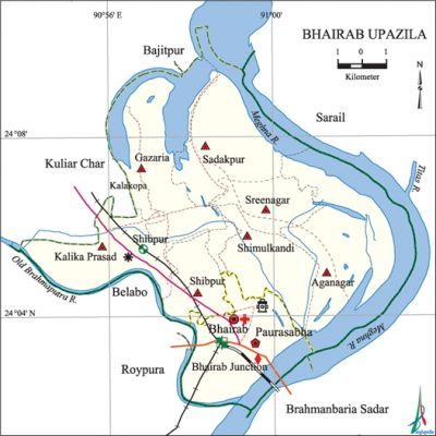
Bhairab Upazila
Bhairab Upazila (kishoreganj district) area 139.32 sq km, located in between 21°11' and 24°02' north latitudes and in between 90°54' and 91°02' east longitudes. It is bounded by bajitpur upazila on the north, raipura and brahmanbaria sadar upazilas on the south, sarail upazila on the east, kuliarchar and belabo upazilas on the west.
Population Total 247166; male 125621, female 121545; Muslim 235847, Hindu 11246' and others 73.
Water bodies Main rivers: old brahmaputra and meghna.
Administration Bhairab Thana was formed in 1906 and it was turned into an upazila in 1983. Bhairab municipality was established in 1958.
| Upazila | ||||||||
| Municipality | Union | Mouza | Village | Population | Density (per sq km) | Literacy rate (%) | ||
| Urban | Rural | Urban | Rural | |||||
|
1 |
7 |
32 |
84 |
93254 |
153912 |
1774 |
53.6 |
32.3 |
| Municipality | ||||||||
|
Area |
Ward |
Mahalla |
Population |
Density |
Literacy rate (%) | |||
|
15.72 |
12 |
26 |
93254 |
5932 |
53.6 | |||
| Union | ||||
| Name of union and GO code | Area (acre) | Population | Literacy rate (%) | |
| Male | Female | |||
|
Aganagar 21 |
6331 |
13964 |
13342 |
23.54 |
|
Kalika Prasad 47 |
3241 |
13435 |
13471 |
32.23 |
|
Gazaria 35 |
4737 |
11411 |
11717 |
32.85 |
|
Shibpur 71 |
1669 |
10400 |
10691 |
35.06 |
|
Shimulkandi 83 |
2866 |
12973 |
12594 |
37.14 |
|
Sreenagar |
2743 |
6624 |
6879 |
33.00 |
|
Sadakpur 59 |
3160 |
8050 |
8361 |
33.75 |
Source Bangladesh Population Census 2001, Bangladesh Bureau of Statistics.

Archaeological heritage and relics Neelkuthi (Shimulkandi), Imambari (Shimulkandi), Jagabandhu Bhaban at village Gazaria, Titumia Bhaban, magnificient building of Rabin Saha at Bhairab Bazar.
History of the War of Liberation On 15 April 1971 the Pak army killed about four hundred innocent civilians including 250 of village Ibrahimpur' of the upazila. Besides, they also killed many people inside the Manikdi Mosque and at Ashuganj. On 13 December the Pak army destroyed the Bhairab Railway Bridge.
Marks of the War of Liberation Memorial sculpture 1 Durjay Bhairab (Bhairab bus stand), Memorial monument 1 Halgara Kheyaghat (Panaullar Char).'
Religious institutions Mosque 208, temple 7, tomb 13, akhra 2. Noted religious institutions: Siddikchar Jami Mosque, Tiyarir Char Jami Mosque, Aganagar Jami Mosque, Shimulkandi Jami Mosque, Shambhupur Jami Mosque, Manikdi Jami Mosque, Kalika Prasad Munsi Bari Jami Mosque, Kalibari Matree Mandir, Gopal Jeor Mandir, Austami Snan Ghat (sacred bathing) of Kalika Prasad.
Literacy rate and educational institutions Average literacy 40.7%; Male 44.8%, female 36.6%. Educational institutions: college 4, technical school and college 2, secondary school 19, primary school 95, kindergarten 12, madrasa 9. Noted educational institutions: Haji Asmat College (1947), Bhairab Technical School and College (1980), Rafikul Islam Girls' College (1987), KB High School (1919), Bangladesh Railway High School (1954), Sreenagar High School (1961), Bhairab M P Pilot Girls' High School (1962), Kalika Prasad High School (1964), Jagannathpur Puratan Primary School (1995).
Newspapers and periodicals Daily: Ekushey Kagoj; weekly: Niropeksha Arunima, Diner Gan, Ujan Sroot; defunct: weekly: Dishari, Gram Bangla, Mufassalchitra; fortnightly: Bhairab.'
Important installations and tourist spots Bangladesh-British Friendship Bridge, Bhairab Railway Bridge, Botanical Garden on the bank of the river Meghna.
Cultural organisations Library 14, theatre group 4, theatre stage 1, cinema hall 3, voluntary association 65, women's organisation 3, literary society 3.
Main sources of income Agriculture 30.08%, non-agricultural labourer 10.17%, industry 1.51%, commerce 23.54%, transport and communication 3.87%, service 8.86%, construction 1.69%, religious service '0.20%, rent and remittance 2.14% and others 17.94%.
Ownership of agricultural land Landowner 43.34%, landless 56.66%; agricultural landowner: urban' 26.41% and rural 53.40%.
Main crops Paddy, jute, peanut, mustard, sugarcane, wheat, potato, pulse, sesame, chilli, coriander, ginger, turmeric, vegetables.
Extinct or' nearly extinct crops Karpus.
Main fruits Mango, black berry, guava, banana.
Fisheries, dairies and poultries Fishery 7, dairy 175, poultry 182, hatchery 1.
Communication facilities Pucca road 127.22 km, semi-pucca road 6.10 km, mud road 125.21 km; waterways 6.48 nautical miles; railways 12.27 km.
Extinct or nearly extinct traditional transport Palanquin.
Noted manufactories Jute mill, rice mill, threshed rice (chira) mill, steel mill, biscuit factory, soap factory, bidi factory, re-rolling industries, silicate industries, welding factory.
Cottage industries Goldsmith, weaving, blacksmith, potteries, embroidery, bamboo work, cane work.
Hats, bazars and fairs Hats and bazars are 40, fairs 3, most noted of which are Bhairab Bazar, Shimulkandi Bazar, Chawk Bazar, Siddik Bazar.
Main exports Fish, bidi, biscuit, lungi, gamchha.
Access to electricity All the wards and unions of the upazila are under rural electrification net-work. However 51.31% of the dwelling households have access to electricity.
Sources of drinking water Tube-well 93.71%, pond 0.11%, tap 2.01% and others 4.17%. The presence of arsenic has been detected 29.95% shallow tube-well water in this upazila.
Sanitation 39.74% (rural 24.62% and urban 65.16%) of dwelling households of the upazila use sanitary latrines and 45.51% (urban 55.38% and rural 28.90%) of dwelling households use non-sanitary latrines; 14.75% of households do not have latrine facilities.
Heath centres Upazila health complex 1, health and family welfare centre 5, railway hospital 1, satellite clinic 2, community clinic 7, clinic 6.
Natural disasters The floods of 1974, 1988, 1998 and 2004 caused heavy loss of life and damage to settlements, livestock, crops and other properties of the upazila.
NGO activities brac, proshika, asa, Global Village, Need, RDA. [Sharif Ahmed]
References Bangladesh Population Census 2001, Bangladesh Bureau of Statistics; Cultural survey report of Bhairab Upazila 2007.
