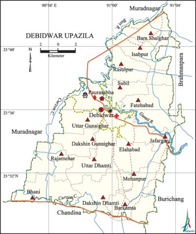
Debidwar Upazila
Debidwar Upazila (comilla district) area 238.36 sq km, located in between 23°29' and 23°42' north latitudes and in between 90°59' and 91°05' east longitudes. It is bounded by muradnagar upazila on the north, chandina upazila on the south, burichang and brahmanpara upazilas on the east, Muradnagar upazila on the west.
Population Total 378401; male 190926, female 187475; Muslim 356257, Hindu 22094, Buddhist 11, Christian 20 and others 19.
Water bodies Main rivers: gumti, Buri; Bhinglabari canal, Curzon canal, Hasan Raja dighi, Deo dighi, Pan dighi, Dhamatipal dighi, Jotshna jalmahal and Bhiralla jalmahal are notable.
Administration Debidwar Thana was formed in 1915 and it was turned into an upazila in 1983.
| Upazila | ||||||||
| Municipality | Union | Mouza | Village | Population | Density (per sq km) | Literacy rate (%) | ||
| Urban | Rural | Urban | Rural | |||||
|
1 |
16 |
142 |
209 |
13994 |
364407 |
1588 |
70.08 |
49.59 |
| Upazila Town | ||||||||
|
Area |
Mouza |
Population |
Density |
Literacy rate (%) | ||||
|
4.32 |
2 |
13994 |
3239 |
70.08 | ||||
| Union | ||||
| Name of union and GO code | Area (acre) | Population | Literacy rate (%) | |
| Male | Female | |||
|
Isabpur 11 |
2965 |
8325 |
8264 |
49.22 |
|
Elahabad 71 |
4039 |
12740 |
12403 |
51.44 |
|
Uttar Gunaighar 53 |
3075 |
9535 |
9880 |
52.80 |
|
Dakshin Gunaighar 59 |
3484 |
9783 |
10018 |
48.60 |
|
Jafarganj 65 |
2964 |
12005 |
11893 |
48.73 |
|
Debidwar 29 |
4593 |
22592 |
22125 |
54.33 |
|
Uttar Dhamti 35 |
3763 |
10200 |
10139 |
48.29 |
|
Dakshin Dhamti 41 |
4044 |
14473 |
11232 |
45.60 |
|
Fatehabad 47 |
5238 |
18834 |
17641 |
52.31 |
|
Bara Shalghar 05 |
3430 |
8398 |
8397 |
50.67 |
|
Barkamta 23 |
3248 |
13186 |
12388 |
56.33 |
|
Bhani 83 |
3888 |
11769 |
11346 |
43.24 |
|
Mohanpur 17 |
3441 |
11956 |
12068 |
48.75 |
|
Rasulpur 89 |
3307 |
9387 |
9282 |
40.92 |
|
Rajamehar 77 |
3776 |
10954 |
10929 |
47.99 |
|
Subil 95 |
3638 |
9789 |
9470 |
60.67 |
Source Bangladesh Population Census 2001, Bangladesh Bureau of Statistics.

Archaeological heritage and relics Baitul Azgar Jami Mosque (Gunaighar), Octagonal Shiva Mandir (Dhamti Bazar).
History of the War of Liberation On 31 March 1971, an encounter was held between the Pak army and the Bangalis on the Comilla-Sylhet highways in which 33 Bangalis were killed. Besides, the Pak army conducted genocides and set many houses on fire on 7 August at Charkamta, 29 September at Jakerganj and on 14 November at Thana Sadar.
Marks of the War of Liberation Mass grave 1 (Muktijoddha Chattar).
Religious institutions Mosque 455, temple 27, tomb 9.
Literacy rate and educational institutions Average literacy 50.39%; male 54.51%, female 46.28%. Educational institutions: college 7, secondary school 47, technical school 3, madrasa 30. Noted educational institutions: Debidwar Reazuddin High School (1918), Gangamandal Raj Institution (1922), Dhamti Islamia Kamil Madrasa (1920).
Newspapers and periodicals Weekly: Debidwar and Comilla Kantha.
Cultural organisations Library 3, club 57, theatre group 1, press club 1.
Tourist spots Debidwar Municipal Park, Debidwar Municipal Children Park.'
Main sources of income Agriculture 54.17%, non-agricultural labourer 1.74%, industry 1.02%, commerce 14.04%, transport and communication 4.57%, service 11.82%, construction 1.22%, religious service 0.33%, rent and remittance 2.90% and others 8.19%.
Ownership of agricultural land Landowner 74.61%, landless 25.39%; agricultural landowner: urban 60.20% and rural 75.17%.
Main crops Paddy, wheat, mustard, corn, potato, vegetables.
Extinct or nearly extinct crops Tobacco, jute, kaun, sesame, peanut, maskalai, masur pulse, gram.
Main fruits Guava, litchi.
Fisheries, dairies and poultries Fishery 7, dairy 5, poultry 30.
Communication facilities Roads: pucca 80.40 km, semi-pucca 196 km, mud road 211.05 km.
Extinct or nearly extinct traditional transport Palanquin, bullock cart, horse carriage.
Noted manufactories Jute mill, cold storage, ice factory, brick field.
Cottage industries Blacksmith, potteries, weaving, net weaving, bamboo work, cane work.
Hats, bazars and fairs Hats and bazars are 15, most noted of which are Dighirpar and Rasulpur Hat, Ponrar Poush Sankranti Mela and Baishakhi Mela.
Main exports Potato, vegetables.
Access to electricity All the wards and unions of the upazila are under rural electrification net-work. However 38.53% of the dwellings have access to electricity.
Sources of drinking water Tube-well 95.17%, tap 0.76%, pond 1.13% and others 3.26%. The presence of arsenic has been detected in the shallow tube-well water of the upazila.
Sanitation 66.35% (rural 65.57% and urban 86.65%) of dwelling households of the upazila use sanitary latrines and 21.36% (rural 21.74% and urban 11.77%) of dwelling households use non-sanitary latrines; 12.28% of households do not have latrine facilities.
Health centres Upazila health complex 1, hospital 1, family planning centre 12, CMH unit 1.
Natural Disasters The cyclone of 1991 caused death of more than one hundred persons and damages to a number of settlements of the upazila. Besides, huge damages to crops were done in 1988, 1998 and 2004 due to floods caused by damage of the flood protection dam on the river Gumti.
NGO activities brac, Pages, asa, nijera kari. [Md Mahmud Hasan Shamim]
References Bangladesh Population Census 2001, Bangladesh Bureau of Statistics; Cultural survey report of Debidwar Upazila 2007.
