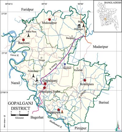
Gopalganj District
Gopalganj District (dhaka division) area 1489.92 sq km, located in between 22°50' and 23°01' north latitudes and in between 89°40' and 90°02' east longitudes. It is bounded by faridpur district on the north, pirojpur and bagerhat districts on the south, madaripur and barisal districts on the east, narail district on the west.
Population Total 1165273; male 592805, female 572468; Muslim 779962, Hindu 371629, Buddhist 13401, Christian 17 and others 264.
Water bodies Main rivers: madhumati, Hunda, Ghagar, old Kumar; Wapda canal and Madaripur Beel Route are notable.
Administration Gopalganj district was established in 1984. Earlier it was a subdivision under Faridpur district. Of the five upazilas of the district gopalganj sadar is the largest (391.35 sq km, it occupies 26.27% of the total area of the district) and tungipara is the smallest upazila (127.25 sq km).
| District | |||||||||
| Area (sq km) | Upazila | Municipality | Union | Mouza | Village | Population | Density (per sq km) | Literacy rate (%) | |
| Urban | Rural | ||||||||
|
1489.92 |
5 |
4 |
68 |
618 |
880 |
113133 |
1052140 |
782 |
51.4 |
| Others Information of District | ||||||||
|
Name of Upazila |
Area |
Municipality |
Union |
Mouza |
Village |
Population |
Density |
Literacy rate |
|
Kashiani |
299.64 |
- |
14 |
151 |
163 |
228647 |
763 |
53.5 |
|
Kotalipara |
362.05 |
1 |
12 |
100 |
197 |
227025 |
627 |
49.8 |
|
Gopalganj Sadar |
391.35 |
1 |
21 |
127 |
197 |
321934 |
823 |
54.5 |
|
Tungipara |
127.25 |
1 |
5 |
34 |
69 |
99462 |
782 |
52.2 |
|
Muksudpur |
309.63 |
1 |
16 |
206 |
254 |
288205 |
931 |
47.1 |
Source Bangladesh Population Census 2001,Bangladesh Bureau of Statistics.

History of the War of Liberation Two freedom fighters were killed in an encounter with the Pak army on 7 April 1971 at Gopalganj sadar upazila. Ten freedom fighters were killed in an encounter between the freedom fighters and the Pak army at village Shasabaria under Urafi Union of the upazila. On 14 May, the Pak army killed about 150 innocent persons at Kalabari of Kotalipara upazila; they also set many houses on fire. On 19 May a contingent of the Pak army killed a number of dwellers in the house of Bangabandhu at Tungipara; they also set the house of Bangabandhu on fire. The Pak army brutally killed 13 persons at village Paikkandhi of Gopalganj sadar upazila in late May. Besides, in collaboration with the local razakars killed nearly 150 persons at village Paikkandi. About 84 Pak soldiers including police and local razakars were killed on 9 August when the freedom fighters and the civilians of Muksudpur upazila launched attack on them. Seven Pak soldiers were killed on 5 October while the freedom fighters attacked the Pak army base at the Bhatiapara Wireless Station of Kashiani upazila. An encounter was held between the freedom fighters and the Pak army and the razakars on 12 October at Bamandanga of Muksudpur upazila in which 22 Pak soldiers and razakars were killed. On the same, day the Pak army brutally killed about 200 villagers at Kalabari area of Kotalipara upazila. Besides, at the end of October about 30 Pak soldiers were killed in an encounter with the freedom fighters in Kashiani upazila. In early December 17 Pak soldiers were killed in an encounter between the freedom fighters and the Pak army in Kashiani upazila.
Marks of the War of Liberation Mass killing site 1, memorial monument 2, mass grave 2.
Literacy rate and educational institutions Average literacy 51.4%; male 55.2%, female 47.4%. Educational institutions: college 23, secondary school 188, primary school 786, community primary school 24, kindergarten 38, madrasa 62. Noted educational institutions: Government SK College (1942), AR Ali Khan College (1942), Muksudpur Degree College (1972), Sheikh Mujibur Rahman Degree College (1986), Ulpur PC High School (1900), Modanmohan High School (1900), Girish Chandra Pilot High School (1902), Kalinagar High School (1907), Orakandi High School (1909), Gopinathpur Secondary School (1911), Nilfa Boyra High School (1917), Batikamari Higher Secondary School (1921), Purbo Kotalipara Union High School (1925), Baultali Sahapur Sammilani High School (1928), Saber Miah Jasimuddin Model' High School (1928), Sajail Gopi Mohan High School (1929), Kumaria Lakshmipur Secondary School (1914), Batikamari Government Primary School (1919), West Kotalipara Union Institution (1923), Bongram Islamia Dakhil Madrasa (1925).
Main sources of income Agriculture 61.75%, non-agricultural labourer 2.23%, industry 0.58%, commerce 13.92%, transport and communication 2.30%, service 11.14%, construction 1.60%, religious service 0.29%, rent and remittance 0.70% and others 5.49%.
Newspapers and periodicals Daily: Jugakatha, Surjasha, Bhorer Bani, Sheren, Banglar Sanket, Bishwa Darpan; Weekly: Janapader Katha; Monthly: Motua Darpan (Orakandi); Defunct: Dipti (1983), Nabadipti (1983), Fulki (1961), Madhumati (1973), Madhuchakra (1983), Sree Haridarshan, Orakandi (1979), Rupali Fite (1987), Alor Dishari '(1977), Rabirasshi (1985), Gopalganj Sahitya Patra (1986).
Folkculture Rhymes, proverbs, riddle, Sarigan, Murshidigan, Haloigan, Bratageeti, Gambhira song are notable.
Tourists spots Bangabandhu Memorial Complex (Tungipara), Akramuzzaman Park' (Arpara, Gopalganj Sadar Upazila). [Rabindranath Adhikari]
See also The upazilas under this district.
References Bangladesh Population Census 2001, Bangladesh Bureau of Statistics; Cultural survey report of Gopalganj District 2007; Cultural survey report of Upazilas of Gopalganj District 2007.
