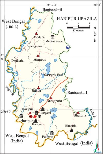
Haripur Upazila
Haripur Upazila (thakurgaon district) area 201.07 sq km, located in between 25°47' and 26°00' north latitudes and in between 88°05' and 88°15' east longitudes. It is bounded by west bengal state of India and ranisankail upazila on the north, West Bengal state of India on the south, Ranisankail upazila on the east, West Bengal state of India on the west.
Population Total 147947; male 74213, female 73734; Muslim 134442, Hindu 12872, Buddhist 1, Christian 319 and others 313. Indigenous communities such as santal, oraon, Munda and Musahar belong to this upazila.
Water bodies Main rivers: nagar, Kulik; Gargaria Beel is notable.
Administration Haripur Thana was formed in 1914 and it was turned into an upazila in 1983.
| Upazila | ||||||||
| Municipality | Union | Mouza | Village | Population | Density (per sq km) | Literacy rate (%) | ||
| Urban | Rural | Urban | Rural | |||||
| - | 6 | 72 | 73 | 7288 | 140659 | 736 | 48.3 | 41.8 |
| Upazila Town | ||||||||
|
Area |
Mouza |
Population |
Density |
Literacy rate | ||||
| 4.11 | 2 | 7288 | 1773 | 48.3 | ||||
| Union | ||||
| Name of union and GO code | Area (acre) | Population | Literacy rate (%) | |
| Male | Female | |||
| Amgaon 13 | 8565 | 13655 | 13823 | 45.2 |
| Gedura 67 | 9269 | 14541 | 14172 | 35.5 |
| Dangipara 54 | 7448 | 12063 | 11811 | 46.2 |
| Bakua 27 | 9141 | 11381 | 11697 | 36.0 |
| Bhaturia 40 | 7631 | 10318 | 10194 | 43.4 |
| Haripur 81 | 7632 | 12255 | 12037 | 46.8 |
Source Bangladesh Population Census 2011, Bangladesh Bureau of Statistics.

Archaeological heritage and relics Medini Sagar Jami Mosque, Gedura Jami Mosque, Bhaturiar Garh, Bir Garh, Bhabanipur Garh (Bhaturia), Zamindar Bari at Haripur, tomb of Shah Makhdum Jalal (R) at Bahrampur.
War of Liberation Haripur was under sector 7 during the war of liberation. During this time encounters between the freedom fighters and the Pak army were held at Kamar Pukur, Bhaturia, Dangipara and Gedura of the upazila. In these encounters 20 freedom fighters including Md. Ismail and Dr. Aziz were killed and 23 were wounded. Haripur Upazila was liberated on 1 December.
For details: see হরিপুর উপজেলা, বাংলাদেশ মুক্তিযুদ্ধ জ্ঞানকোষ (Encyclopedia of Bangladesh War of Liberation), বাংলাদেশ এশিয়াটিক সোসাইটি, ঢাকা ২০২০, খণ্ড ১০।
Religious institutions Mosque 331, temple 23, church 2, tomb 5. Noted religious institutions: Haripur Jami Mosque, Balihara Jami Mosque, Jadurani Haramai Jami Mosque, Hagri Mosque (Khalra), Medni Sagar Shahi Mosque.
Literacy rate and educational institutions Average literacy 42.1%; male 45.0%, female 39.2%. Educational institutions: college 20, secondary school 55, primary school 84, madrasa 20. Noted educational institutions: Muslem Uddin College (1984), Haripur Bilateral High School (1936), Jadurani High School (1965), Kanthaldangi College (1967), Birgarh Government Model Primary School (1920), Minapur Government Primary School (1923), Kanthaldangi Government Primary School (1930), Haripur Government Primary School (1953), Birgarh Darul Ulum Sharifia Madrasa.
Newspapers and periodicals Angikar (irregular).
Cultural organisations Library 1, club 30, women's organisation 96, cinema hall 1, playground 10.
Main sources of income Agriculture 83.03%, non-agricultural labourer 3.08%, commerce 6.09%, service 2.73%, construction 0.59%, religious service 0.08%, rent and remittance 0.05% and others 4.35%.
Ownership of agricultural land Landowner 58.12%, landless 41.88%; agricultural landowner: urban 49.16% and rural 58.57%.'
Main crops Paddy, wheat, corn, cabbage, potato, pulse, brinjal, tomato, vegetables.
Extinct or nearly extinct crops Aush paddy, kaun, khesari, gram, mash' kalai, arhar.
Main fruits Jackfruit, betel nut, mango, litchi, banana, papaya, water-melon, guava.
Fisheries, dairies and poultries Dairy 8, poultry 48, hatchery 1.
Communication facilities Pucca road 56 km, Semi-pucca road 6 km, mud road 405 km.
Extinct or nearly extinct traditional transport Palanquin, horse carriage, bullock cart.
Noted manufactories Ice factory 1, oil mill 3, husking mill 85, saw mill 3, engineering workshop 2, welding factory 8.
Cottage industries Goldsmith 4, blacksmith 22, potteries 10, embroidery 35, bamboo work 20,' wood work 30,' mat work 200.
Hats, bazars and fairs Hats and bazars are 15, fairs 5, most noted of which are Jadurani Hat, Kaliganj Hat, Kanthaldangi Hat, Dhirganj Hat, Chawrangi Hat, Mashagaon Hat and Raghab Mela.
Main exports Paddy, rice, wheat, cabbage, brinjal, tomato, water-melon, mango, litchi, mat.
Access to electricity All the unions of the upazila are under rural electrification net-work. However 22.6% of the dwelling households have access to electricity.
Sources of drinking water Tube-well 98.2%, tap 0.1% and others 1.7%.
Sanitation 37.6% of dwelling households of the upazila use sanitary latrines and 39.2% of dwelling households use non-sanitary latrines; 23.2% of households do not have latrine facilities.
Health centres Upazila health complex 1, satellite clinic 1.
NGO activities brac, rdrs, ESDO, proshika. [Md. Abdul Gaffar]
References Bangladesh Population Census 2001 and 2011, Bangladesh Bureau of Statistics; Cultural survey report of Haripur Upazila 2007.
