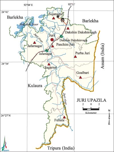
Juri Upazila
Juri Upazila (maulvibazar district) area 186.30 sq km, located in between 24°22' and 24°41' north latitudes and in between 91°01' and 92°13' east longitudes. It is bounded by barlekha upazila on the north, tripura state of India on the south, Tripura and assam state of India on the east and kulaura upazila on the west.
Population 148958; male 73240, female 75718; Muslim 97271, Hindu 48064, Buddhist 5, Christian 530 and others 3088. indigenous communities such as khasia and manipuri' belong to this upazila.
Water bodies Main river: Juri; Hakaluki Haor, Ragnachhara, Putichhara, Kawlichhara Kuiachhara canals and Chalta, Tural, Pingla and Garkuri beels are notable.
Administration Juri Upazila was formed on 26 August 1984.
| Upazila | ||||||||
| Municipality | Union | Mouza | Village | Population | Density (per sq km) | Literacy rate (%) | ||
| Urban | Rural | Urban | Rural | |||||
| - | 6 | 71 | 142 | 13291 | 135667 | 800 | 57.2 | 51.9 |
| Upazila Town | ||||||||
|
Area |
Mouza |
Population |
Density (per sq km |
Literacy rate (%) | ||||
| 6.45 | 1 | 13291 | 2061 | 57.2 | ||||
| Union | ||||
| Name of union and GO code | Area (acre) | Population | Literacy rate (%) | |
| Male | Female | |||
| Goalbari 29 | 8058 | 10895 | 11646 | 53.5 |
| Jafarnagar 47 | 9525 | 19275 | 20198 | 56.3 |
| Paschim Juri 55 | 7408 | 11493 | 11421 | 51.8 |
| Purba Juri 67 | 8062 | 9056 | 9509 | 62.3 |
| Fultala 23 | 7364 | 9726 | 9461 | 39.7 |
| Sagarnal 83 | 8411 | 12795 | 13483 | 47.9 |
Source Bangladesh Population Census 2011, Bangladesh Bureau of Statistics.

War of Liberation During the War of Liberation, the freedom fighters of this upazila carried out operations in different tea gardens against the Pak army and destroyed a number of culvert and bridges. On 2 and 3 December 1971 fierce battles were fought between the joint forces and the Pak army at Fultala, Sagarnal and Kapnapahar. Juri upazila was liberated on 4 December 1971.There is a mass killing site at Jagadhari pond behind the Juri High School.
For details: see জুড়ী উপজেলা, বাংলাদেশ মুক্তিযুদ্ধ জ্ঞানকোষ (Encyclopedia of Bangladesh War of Liberation), বাংলাদেশ এশিয়াটিক সোসাইটি, ঢাকা ২০২০, খণ্ড ৪।
Religious institutions Mosque 170, temple 40, church 1.
Literacy rate and educational institutions Average literacy 52.3, male 54.3% and female 50.5%. Noted educational institutions: College 2, secondary school 12, primary school 70, BRAC operated School 40, kindergarten 10, madrasa 20. Educational institutions: Tayebunnesa Khanam Academy Degree College (1994), Juri High School (1994), Nayabazar Ahmadia Fazil Madrasa (1958).
Cultural organisations Library 5.
Main sources of income Agriculture 39.48%, non-agricultural labourer 12.77%, commerce 11.85%, transport and communication 1.48%, service 7.31%, construction 0.94%, religious service 0.33%, rent and remittance 2.02% and others 18.80%.
Ownership of agricultural land Landowner 37.35%, landless 62.65%.
Main crops Paddy, jute, wheat, pulse and tea.
Main fruits Mango, jackfruit, banana, orange, pineapple.
Communication facilities Pucca road 57 km, semi-pucca road 8 km, mud road 155 km; waterway 5 km.
Noted manufactories Saw mill, rice mill, tea processing factory, aluminum factory, hardboard factory, cold storage, etc.
Cottage industries Pottery, cane works, Shitalpati.
Hats, bazars and fairs Hats and bazars are 15.
Main export Paddy and tea.
Access to electricity All the unions of the upazila are under rural electrification net-work. However 42.6% of the dwelling households have access to electricity.
Sources of drinking water Tube-well 64.5%, tap 2.0% and others 33.5%.
Sanitation 35.6% of dwelling households of the upazila use sanitary latrines and 51.0% of dwelling houses use non-sanitary latrines; 13.4% of households do not have latrine facilities.
Health centres Hospital 1, union health and family planning centre 6, community clinic 20. Besides, each tea garden has its own health centre for tea labourers.
NGO activities brac, asa. [Md. Abdul Mannan]
References Bangladesh Population Census 2001 and 2011, Bangladesh Bureau of Statistics.
