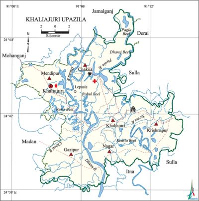
Khaliajuri Upazila
Khaliajuri Upazila (netrokona district) area 286.88.42 sq km, located in between 24°36' and 24°50' north latitudes and in between 90°00' and 90°16' east longitudes. It is bounded by mohanganj and jamalganj upazilas on the north, itna upazila on the south, sulla and derai upazilas on the east, madan upazila on the west.
Population Total 93170; male 48836, female 44334; Muslim 56427, Hindu 36546, Buddhist 35 and others 162.
Water bodies Main rivers: Dhanu, Piyain, Surma, Chinai; Ruksi, Rahul, Pagla, Keuria and Dharaj beels are notable.
Administration Khaliajuri Thana was formed in 1906 and it was turned into an upazila in 1983.
| Upazila | ||||||||
| Municipality | Union | Mouza | Village | Population | Density (per sq km) | Literacy rate (%) | ||
| Urban | Rural | Urban | Rural | |||||
|
- |
6 |
61 |
66 |
6205 |
76117 |
330 |
30.6 |
34.8 |
| Upazila Town | ||||||||
|
Area (sq km) |
Mouza |
Population |
Density (per sq km) |
Literacy rate (%) | ||||
|
18.21 |
1 |
6205 |
341 |
30.6 | ||||
| Union | ||||
| Name of union and GO code | Area (acre) | Population | Literacy rate (%) | |
| Male | Female | |||
|
Krishnapur 54 |
6395 |
7289 |
6642 |
31.73 |
|
Khaliajuri 40 |
10936 |
7364 |
6562 |
33.56 |
|
Chakua 13 |
18834 |
10700 |
9522 |
33.40 |
|
Gazipur |
- |
- |
- |
- |
|
Nagar 81 |
9418 |
5099 |
4838 |
46.59 |
|
Mendipur 67 |
14302 |
12574 |
11732 |
32.12 |
Source Bangladesh Population Census 2001, Bangladesh Bureau of Statistics.
Religious institutions Mosque 40, temple 17, tomb 5.
Literacy rate and educational institutions Average literacy 32.8%; male 36.1%, female 29.5%. Noted educational institutions: Saldigha GG High School (1954), Khaliajuri High School (1967), Kutubpur High School (1964).

Newspapers and periodicals Literary periodical 'Dhanu' (defunct).
Cultural organisations Club 12, library 1, women organisation 92, playground 5.
Main sources of income Agriculture 80.59%, non-agricultural labourer 3.79%, industry 0.19%, commerce 6.16%, transport and communication 0.13%, service 2.18%, construction 0.35%, religious service 0.20%, rent and remittance 0.09% and others 6.32%.
Ownership of agricultural land Landowner 58.55%, landless 41.45%; agricultural landowner: urban 51.41% and rural 59.19%.
Main crops Paddy.
Extinct or nearly extinct crops Sesame, linseed, mustard, kaun.
Main fruits Mango, jackfruit, coconut, banana, papaya.
Fisheries, dairies and poultries This upazila has a number of fisheries and poultries.
Communication facilities Pucca road 3 km, mud road 300 km.
Extinct or nearly extinct traditional transport Palanquin, bullock cart, horse carriage.
Cottage industries Goldsmith, blacksmith, potteries, embroidery, bamboo and wood work.
Hats, bazars and fairs Hats and bazars are 7, most noted of which are Lepsia, Khaliajuri, Krishnapur and Trimohoni bazars; Chaitra Samkranti Mela at Barantar village.
Access to electricity All the unions of the upazila are under rural electrification net-work. However 30.01% of the dwelling households have access to electricity.
Sources of drinking water Tube-well 90.12%, tap 0.58%, pond 4.29% and others 5.01%. The presence of intolerable level of arsenic has been detected in shallow tube-well water of the upazila.
Sanitation 23.19% (rural 20.86% and urban 49.05%) of dwelling households of the upazila use sanitary latrines and 64.29% (rural 66.57% and urban 39.07%) of dwelling households use non-sanitary latrines; 12.52% of households do not have latrine facilities.
Health centres Upazila health complex 1, palli satellite clinic 1, family welfare centre 1, dispensary 1, hospital 1.
Natural disasters The floods of 1988 and 1996 caused heavy damages to livestock and other properties of the upazila.'
NGO activities Operationally important NGOs are proshika, Concern Bangladesh, Khaliajuri Palli Unnayan Federation. [Jiban Kumar Chanda]
References Bangladesh Population Census 2001, Bangladesh Bureau of Statistics; Cultural survey report of Khaliajuri Upazila 2007.
