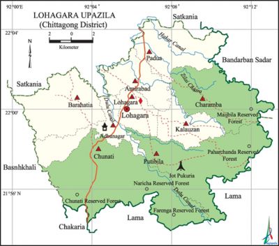
Lohagara Upazila (Chittagong District)
Lohagara Upazila (chittagong district) area 258.87 sq km, located in between 21°54' and 22°05' north latitudes and in between 92°00' and 92°13' east longitudes. It is bounded by satkania upazila on the north, chakaria and lama upazilas on the south, bandarban sadar and Lama upazilas on the east, banshkhali upazila on the west.
Population Total 279913; male 135717, female 144196; Muslim 251229, Hindu 22609, Buddhist 6038, Christian 22 and others 15.
Water bodies Tonkaboti, Dalu, Hadar and Hanqar canals; Jelaichhara and Dhalai beels are notable.
Administration Lohagara Thana was formed in 1981 and it was turned into an upazila in 1983.
| Upazila | ||||||||
| Municipality | Union | Mouza | Village | Population | Density (per sq km) | Literacy rate (%) | ||
| Urban | Rural | Urban | Rural | |||||
| - | 9 | 40 | 43 | 30815 | 249098 | 1081 | 60.2 | 48.6 |
| Upazila Town | ||||||||
|
Area (sq km) |
Mouza |
Population |
Density (per sq km) |
Literacy rate (%) | ||||
| 9.78 | 1 | 30815 | 3151 | 60.2 | ||||
| Union | ||||
| Name of union and GO code | Area (acre) | Population | Literacy rate (%) | |
| Male | Female | |||
| Adhunagar 3 | 4574 | 9696 | 11092 | 53.7 |
| Amirabad 10 | 4361 | 18018 | 19285 | 58.7 |
| Kalauzan 43 | 3996 | 13334 | 15013 | 45.2 |
| Charamba 25 | 8027 | 12496 | 12974 | 40.8 |
| Chunati 32 | 15128 | 16513 | 16902 | 43.0 |
| Padua 73 | 6640 | 19818 | 21024 | 49.1 |
| Putibila 80 | 10920 | 12444 | 13339 | 33.7 |
| Barahatatia 18 | 7548 | 15648 | 17307 | 52.3 |
| Lohagara 62 | 2776 | 17750 | 17260 | 59.5 |
Source Bangladesh Population Census 2011, Bangladesh Bureau of Statistics.

Archaeological heritage and relics Machhdia Buddhist Temple (Adhunagar, 18th century), Buddhist Temple and other royal establishments at Chendirpuni, Gupta Zamindar Bari at Padua, Adhunagar Budhist Temple, Magadeshwari Temple at Maghdighi.
War of Liberation In 1971, the Pak army conducted heavy plundering and set many houses of the upazila on fire. They brutally killed 15 villagers of Amirabad Banik Para. The local razakars captured 12 persons from the Hindu Para (Hindu populated area) of Chunti Deputy Bazar, took them to the Chandnaish Police Station and later killed all of them. Freedom fighters carried out operations at a few places of the upazila including the razakar camps at Amirabad and Battali during the WAR OF LIBERATION and had killed 17 rajakars at Jotpukuria. A mass garve has been discovered at Jotpukuria of Putibila union.
For details: see লোহাগাড়া উপজেলা, বাংলাদেশ মুক্তিযুদ্ধ জ্ঞানকোষ (Encyclopedia of Bangladesh War of Liberation), বাংলাদেশ এশিয়াটিক সোসাইটি, ঢাকা ২০২০, খণ্ড ৯।
Religious institutions Mosque 62, temple 9, tomb 4, church 2, pagoda 6. Noted religious institutions: Lohagara Mosque, Chunati Jami Mosque, Barahatatia Central Jami Mosque, tomb of Hazrat Shah Pir Auliya, tomb of Chunati Shah Shaheb Kebla, tomb of Bara Auliya, Mochhdia Buddhist Temple, Adhunagar Temple.
Literacy rate and educational institutions Average literacy 49.2%; male 49.9%, female 48.6%. Educational institutions: college 3, secondary school 25, primary school 97, madrasa 22. Noted educational institutions:' Bara Auliya Degree College (1983), Chunati Mahilla College (1989), North Amirabad MB High School (1932), North Amirabad Government Primary School (1935), Golambari High School (1937), Chunati Kalauzan Gorsundar High School (1945), Chunati Government Primary School (1919), Suk Chhari Government Primary School (1929), Kalauzan Government Primary School (1929), Sener Hat Government Primary School (1932), Hakimian Kamil Madrasa (1937).
Cultural organisations Library 11, club 32, playground 20,' cultural organisation 2. Tourist spots Chunati Reserve Forest, Padua Forest Area.
Main sources of income Agriculture 39.29%, non-agricultural labourer 5.40%, industry 0.82%, commerce 17.71%, transport and communication 3.43%, service 14.58%, construction 1.59%, religious service 0.49%, rent and remittance 5.19% and others 11.50%.
Ownership of agricultural land Landowner 63.88%, landless 36.12%; agricultural landowner: urban 64.13% and rural 61.74%.'
Main crops Paddy, potato, sugarcane, chilli, felong.
Extinct or nearly extinct crops Sesame, linseed, watermelon.
Main fruits Banana, papaya, guava, hog plum, plum.
Fisheries, dairies and poultries Fishery 2322 (ponds), dairy 5, poultry 139, hatchery (fish) 22.
Communication facilities Pucca road 83 km, semi-pucca road 114 km, mud road 917 km.
Noted manufactories Rice mill, ice factory, biscuit factory, textile mill,' plywood factory.
Cottage industries Goldsmith, blacksmith, potteries, pati, fishing net, bamboo work, wood work.
Hats, bazars and fairs Hats and bazars are 24, fairs 3, most noted of which are Darbesh Hat, Tewari Hat, Khan Hat, Hindur Hat, Sener Hat and Monu Fakir Hat.
Main exports Paddy, mosquito net, net, garments.
Access to electricity All the unions of the upazila are under rural electrification net-work. However 60.1% of the dwelling households have access to electricity.
Sources of drinking water Tube-well 89.4%, tap 3.1% and others 7.5%.
Sanitation 64.2% of dwelling households of the upazila use sanitary latrines and 30.8% of dwelling households use non-sanitary latrines; 5.0% of households do not have latrine facilities.
Health centres Upazila health centre 1, family planning centre 5, union health centre 4, clinic 5,
NGO activities Operationally important NGOs are brac, asa, Uddipan, Protikrit, Education and Social Development, Ashrai, Sapnosiri. [Md. Abul Manjur]
References Bangladesh Population Census 2001 and 2011, Bangladesh Bureau of Statistics; Cultural survey report of Lohagara Upazila 2007.
