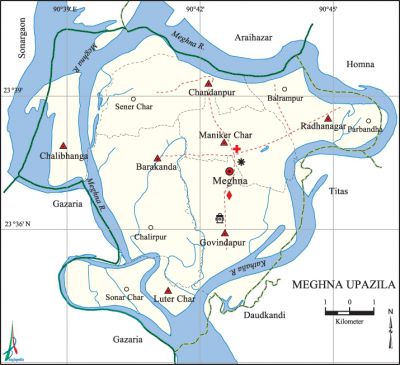
Meghna Upazila
Meghna Upazila (comilla district) area 98.47 sq km, located in between 23°34' and 23°41' north latitudes and in between 90°38' and 90°46' east longitudes. It is bounded by araihazar upazila (narayanganj) on the north, daudkandi upazila on the south, homna and titas upazilas on the east and sonargaon (Narayanganj) and gazaria upazilas on the west.
Population Total' 96970; male 47716, female 49254; Muslim 92032, Hindu 4925 and others 13.
Water bodies Main rivers: meghna and Kathalia.'
Administration Meghna Thana was turned into an upazila in 1999.
| Upazila | ||||||||
| Municipality | Union | Mouza | Village | Population | Density (per sq km) | Literacy rate (%) | ||
| Urban | Rural | Urban | Rural | |||||
|
- |
7 |
40 |
104 |
- |
96970 |
984 |
- |
33.84 |
| Union | ||||
| Name of union and GO code | Area (acre) | Population | Literacy rate (%) | |
| Male | Female | |||
|
Chandanpur 19 |
2756 |
5015 |
5302 |
29.93 |
|
Chalibhanga 21 |
2644 |
6076 |
6128 |
20.75 |
|
Govindapur 43 |
6964 |
9026 |
9185 |
33.33 |
|
Barakanda 12 |
5011 |
10233 |
10190 |
38.56 |
|
Maniker Char 71 |
2495 |
5597 |
6062 |
40.03 |
|
Radhanagar 95 |
2374 |
6391 |
6724 |
33.18 |
|
Luter Char 53 |
- |
5378 |
5663 |
37.34 |
Source Bangladesh Population Census 2001, Bangladesh Bureau of Statistics.

Religious institutions Mosque 221, temple 6, Math 1.
Literacy rate and educational institutions Average literacy 33.34%; male 38.04%, female 29.92%. Educational institutions: college 2, secondary school 7, primary school 51, community primary school 1, madrasa 2. Noted educational institutions: Maniker Char College (1970), Daulat Hossain Multilateral High School (1938), Maniker Char LL High School (1946), Sonar Char High School (1967), Muzzafor Ali High School (1967), Chandanpur MA High School (1971).
Cultural organisations Library 2.
Main sources of income Agriculture 53.71%, non-agricultural labourer 1.52%, industry 0.99%, commerce 14.88%, transport and communication 1.88%, service 6.39%, construction 0.93%, religious services 0.21%, rent and remittance 6.62% and others 13.28%.
Ownership of agricultural land Landowner 74.07%, landless 25.93%.
Main crops Paddy, jute, wheat, pulses.
Extinct or nearly extinct crops Kaun, sesame.
Main fruits Mango, jackfruit, coconut, kul, water melon, palm.
Communication facilities Pucca road 168 km, mud road 12 km.
Extinct or nearly extinct traditional transport Palanquin, bullock cart.
Cottage industries Jute goods, pottery, etc.
Access to electricity All the unions of the upazila are under rural electrification net-work. However 11.85% of the dwelling households have access to electricity.
Sources of drinking water Tube-well 94.61%, tap 0.51%, pond 0.99% and others 3.89%.
Sanitation 21.84% of dwelling households of the upazila use sanitary latrines and 70.45% of dwelling households use non-sanitary latrines; 7.71%' of households do not have latrine facilities.
Health centres Hospital 1, family planning centre 7, community health clinic 7, diagnostic centre 1.
NGO activities Operationally important NGOs are brac, asa, proshika, CARE. [Md. Habibur Rahman Bhuiya]
References Bangladesh Population Census 2001, Bangladesh Bureau of Statistics; Cultural survey report of Meghna Upazila 2007.
