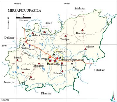
Mirzapur Upazila
Mirzapur Upazila (tangail district) area 373.89 sq km, located in between 24°01' and 24°13' north latitudes and in between 89°58' and 90°15' east longitudes. It is bounded by sakhipur and basail upazilas on the north, kaliakair and dhamrai upazilas on the south, Kaliakair upazila on the east, delduar and nagarpur upazilas on the west.
Population Total 366609; male 185445, female 181164; Muslim 317404, Hindu 48932, Buddhist 204, Christian 36 and others 33.
Water bodies Main rivers: bangshi, Futjani, turag.
Administration Mirzapur Thana, now an upazila, was formed in 1913.
| Upazila | ||||||||
| Municipality | Union | Mouza | Village | Population | Density (per sq km) | Literacy rate (%) | ||
| Urban | Rural | Urban | Rural | |||||
|
1 |
13 |
207 |
219 |
29535 |
337074 |
981 |
59.9 |
47.2 |
| Municipality | ||||||||
|
Area (sq km) |
Ward |
Mahalla |
Population |
Density (per sq km) |
Literacy rate (%) | |||
|
8.58 |
9 |
16 |
23537 |
2743 |
62.4 | |||
| Upazila Town | ||||||||
|
Area (sq km) |
Mouza |
Population |
Density (per sq km) |
Literacy rate (%) | ||||
|
6.92 |
3 |
5998 |
867 |
50.3 | ||||
| Union | ||||
| Name of union and GO code | Area (acre) | Population | Literacy rate (%) | |
| Male | Female | |||
|
Ajgana 13 |
13607 |
20373 |
19444 |
42.70 |
|
Anaitara 15 |
5643 |
11511 |
12350 |
49.12 |
|
Uarsi 94 |
7128 |
11815 |
12538 |
50.61 |
|
Gorai 55 |
7300 |
23062 |
20417 |
50.51 |
|
Jamurki 63 |
5211 |
16314 |
15349 |
54.21 |
|
Tarafpur 87 |
7061 |
11385 |
10797 |
40.79 |
|
Fatehpur 47 |
6289 |
11150 |
11303 |
51.33 |
|
Bahuria 23 |
7175 |
16684 |
16933 |
43.38 |
|
Banshtail 34 |
11985 |
14424 |
13571 |
32.37 |
|
Banail 31 |
5660 |
11508 |
11433 |
56.85 |
|
Bhatgram 39 |
4832 |
10306 |
9875 |
49.15 |
|
Mahera 71 |
4633 |
11854 |
11821 |
48.49 |
|
Mirzapur 79 |
1126 |
3494 |
3361 |
48.74 |
Source Bangladesh Population Census 2001, Bangladesh Bureau of Statistics.

Archaeological heritage and relics Three-domed ancient mosque at Pakulla (eighteenth century).
History of the War of Liberation A battle was fought between the freedom fighters and the Pak army on 3 April 1971 at Goran Satiachara in which 33 freedom fighters were killed and so were a number of Pak soldiers.
Marks of the War of Liberation Mass grave 1 (Goran Satiachara), mass killing site 1 (Pakulla).
Religious institutions Mosque 306, temple 105. Noted religious institutions: Pakulla Mosque, Pakulla Math, Sawali Kali Mandir.
Literacy rate and educational institutions Average literacy 48.3%; male 53.1%, female 43.4%. Educational institutions: medical college 1, college 6, cadet college 1, police training centre 1, nursing institute 2, secondary school 44, primary school 159, madrasa 14. Noted educational institutions: Kumudini Medical College (2001), Mirzapur Cadet College (1965), Mahera Police Training School (1970), Mahera Ananda High School (1990), Jamurki Nawab Sir Abdul Ghani Multilateral High School (1914), Mirzapur SK Pilot High School (1915), Maisamura BK High School (1920), Grasthamatia SC High School (1927), Barabi Nardana Bangladesh High School (1948), Bhatgram Dayamayi Chatushpathi.
Newspapers and periodicals Weekly: Bangshai (irregular).
Cultural organisations Club 60, cultural society 1, theatre stage 1, playground 50.
Main sources of income Agriculture 54.94%, non-agricultural labourer 3.02%, industry 1.06%, commerce 12.53%, transport and communication 2.02%, service 11.60%, construction 1.26%, religious service 0.19%, rent and remittance 4.01% and others 9.37%.
Ownership of agricultural land Landowner 66.05%, landless 33.95%; agricultural landowner: urban 50.90% and rural 67.24%.
Main crops Paddy, jute, mustard, potato, wheat, pulse, sugarcane, vegetables.
Extinct or nearly extinct crops Motor, khesari, sweet potato, sesame, black gram.
Main fruits Mango, jackfruit, banana, litchi, papaya.
Fisheries, dairies and poultries Fishery 250, dairy 78, poultry 350.
Communication facilities Pucca road 30 km, semi-pucca road 5 km, mud road 200 km; waterway 32 nautical miles.
Extinct or nearly extinct traditional transport Palanquin, dhuli, horse carriage, bullock cart.
Noted manufactories Cotton mill, spinning mill, jute mill, biscuit factory, battery factory, welding factory.
Cottage industries Goldsmith, blacksmith, brass work, potteries, weaving, wood work.
Main exports potato, jute, sugarcane molasses.
Access to electricity All the wards and unions of the upazila are under rural electrification net-work. However 42.59% of the dwelling households have access to electricity.
Sources of drinking water Tube-well 88.40%, tap 1.58%, pond 0.69% and others 9.33%.
Sanitation 34.36% (rural 32.25% and urban 61.03%) of dwelling households of the upazila use sanitary latrines and 50.87% (rural 52.16% and urban 34.45%) of dwelling households use non-sanitary latrines; 14.77% of households do not have latrine facilities.
Health centres Hospital 1, upazila health centre 1, family planning centre 12, satellite clinic 6, clinic 12.
Natural disasters Many people were victims of the famine of 1943. Besides, the flood of 1988 caused heavy damages to settlements, livestock and other properties of the upazila.
NGO activities Operationally important NGOs are brac, proshika. [Malay Shaha]
References Bangladesh Population Census 2001, Bangladesh Bureau of Statistics; Cultural survey report of Mirzapur Upazila 2007.
