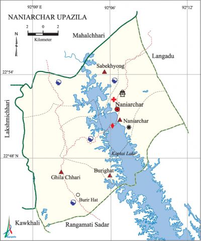
Naniarchar Upazila
Naniarchar Upazila (rangamati district) area 393.68 sq km, located in between 22°43' and 22°57' north latitudes and in between 92°02' and 92°11' east longitudes. It is bounded by mahalchhari (rangamati) upazila on the north, rangamati sadar and kawkhali upazilas on the south, langadu upazila on the east, lakshmichhari (khagrachhari) upazila on the west.
Population Total 39190; male 20685, female 18505; Muslim 5740, Hindu 965, Buddhist 353, Christian 32083 and others 49.
Water bodies Main river: kaptai lake occupies about one-fifths of the total area of this upazila.
Administration Naniarchar Thana was formed in 1979 and it was turned into an upazila in 1983.
| Upazila | ||||||||
| Municipality | Union | Mouza | Village | Population | Density (per sq km) | Literacy rate (%) | ||
| Urban | Rural | Urban | Rural | |||||
|
- |
4 |
20 |
146 |
6028 |
33162 |
100 |
52.8 |
35.6 |
| Upazila Town | ||||||||
|
Area (sq km) |
Mouza |
Population |
Density (per sq km) |
Literacy rate (%) | ||||
|
23.31 |
2 |
6028 |
259 |
52.78 | ||||
| Union | ||||
| Name of union and GO code | Area (acre) | Population | Literacy rate (%) | |
| Male | Female | |||
|
Ghila Chhari 38 |
20480 |
3974 |
3635 |
34.84 |
|
Naniarchar 57 |
26240 |
6106 |
5244 |
42.84 |
|
Burighat 19 |
21120 |
5833 |
5394 |
40.71 |
|
Sabekhyong 76 |
29440 |
4772 |
4232 |
32.98 |
Source Bangladesh Population Census 2001, Bangladesh Bureau of Statistics.

History of the War of Liberation Many people were killed or wounded in an encounter between the freedom fighters and the Pak army at village Kadamtali under Burighat union of the upazila. In 1971 Freedom Fighter Lance Naik Birsrestha munshi abdur rauf was killed in a frontal battle with the Pak army.
Marks of the War of Liberation Birsrestha Munshi Abdur Rauf Memorial Monument.
Religious institutions Mosque 15, temple 2, pagoda 25, buddhist vihara 30, church 1.
Literacy rate and educational institutions Average literacy 38.4%; male 45.8%, female 30.1%.
Cultural organisations Club 15, women organisation 6.
Tourist spots Ancient Buddhist Bihara at village Khullangpara.
Main sources of income Agriculture 80.74%, non-agricultural labourer 2.47%, commerce 5.30%,' service 3.66%, religious service' 0.19%, rent and remittance 0.19% and others 7.45%.
Ownership of agricultural land Landowner 74.23%, landless 25.77%; agricultural landowner: urban 60.79% and rural 76.61%.
Main crops Paddy, sugarcane, maize, pulse, cotton, tobacco, potato.
Extinct or nearly extinct crops Sesame, linseed.
Noted manufactories Garments.
Main fruits Mango, jackfruit, litchi, banana, water-melon, pineapple, papaya.
Fisheries, dairies and poultries Fishery 6, dairy 1, poultry 1.
Communication facilities Pucca road 35 km, semi-pucca road 15 km, mud road 45 km.
Cottage industries Goldsmith, blacksmith, bamboo work, cane work, wood work, weaving (done by waist loom).
Hats, bazars and fairs Hats and bazars are 5, fair 1, most noted of which are Burighat Bazar, Ghila Chhari Bazar, Bet Chhari Bazar, Naniarchar Hat and Boichakro Mela.
Main exports Wood, bamboo, jackfruit.
Access to electricity All the unions of the upazila are under rural electrification net-work. However 8.22% of the dwelling households have access to electricity.
Sources of drinking water Tube-well 26.68%, tap 0.87%, pond 4.81% and others 67.64%. The presence of arsenic has been detected in 3% shallow tube-well water of the upazila.
Sanitation 9.92% (rural 8.09% and urban 20.32%) of dwelling households of the upazila use sanitary latrines and 81.39% (rural 83.92% and urban 67.05%) of dwelling households use non-sanitary latrines; 8.69% of households do not have latrine facilities.
Natural resources In 1982 natural gas has been detected in Burighat area; however, it has not yet been possible to extract this gas.
Health centres Upazila health complex 1, union health centre 4, family planning centre 4. [Gautam Chandra Modak]
References Bangladesh Population Census 2001, Bangladesh Bureau of Statistics; Cultural survey report of Naniarchar Upazila 2007.
