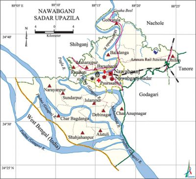
Nawabganj Sadar Upazila
Nawabganj Sadar Upazila (nawabganj district) area 451.80 sq km, located in between 24°25' and 24°43' north latitudes and in between 88°05' and 88°26' east longitudes. It is bounded by nachole and shibganj (Nawabganj) upazilas on the north, west bengal state of India on the south, tanore and godagari upazilas on the east, Shibganj upazila on the west.
Population Total 452650; male 227301, female 225349; Muslim 432416, Hindu 18831, Buddhist 813, Christian 24 and others 566. Indigenous communities such as oraon, santal, Mahali, Murari, Pahan belong to this upazila.
Water bodies Main rivers: padma, mahananda, Pagla; Goaha Beel is notable.
Administration Nawabganj Thana was formed in 1899 and it was turned into an upazila in1984.
| Upazila | ||||||||
| Municipality | Union | Mouza | Village | Population | Density (per sq km) | Literacy rate (%) | ||
| Urban | Rural | Urban | Rural | |||||
|
1 |
14 |
174 |
211 |
152223 |
300429 |
1002 |
53.8 |
29.8 |
| Municipality | ||||||||
|
Area (sq km) |
Ward |
Mahalla |
Population |
Density (per sq km) |
Literacy rate (%) | |||
|
34.35 |
15 |
70 |
152223 |
4432 |
53.8 | |||
| Union | ||||
| Name of union and GO code | Area (acre) | Population | Literacy rate (%) | |
| Male | Female | |||
|
Alatuli |
- |
- |
- |
- |
|
Islampur 39 |
2216 |
12892 |
11931 |
21.36 |
|
Gobratala 33 |
8761 |
11446 |
10917 |
35.37 |
|
Char Anupnagar 20 |
1330 |
5227 |
5163 |
31.38 |
|
Char Bagdanga 22 |
8284 |
8220 |
8240 |
18.84 |
|
Jhilim 44 |
16260 |
9971 |
9029 |
38.39 |
|
Debinagar 27 |
10377 |
12553 |
12038 |
24.63 |
|
Narayanpur 67 |
9351 |
8029 |
7480 |
24.26 |
|
Baragharia 19 |
1330 |
9787 |
10139 |
37.42 |
|
Balidanga 18 |
8975 |
15081 |
14943 |
40.62 |
|
Maharajpur 55 |
1526 |
11210 |
11654 |
34.36 |
|
Ranihati 83 |
1895 |
14245 |
14879 |
35.55 |
|
Shahjahanpur 89 |
2864 |
10266 |
9802 |
16.03 |
|
Sundarpur 94 |
7628 |
14082 |
13873 |
28.02 |
Source Bangladesh Population Census 2001, Bangladesh Bureau of Statistics.

Archaeological heritage and relics Chanpai Jami Mosque (reign of Alauddin Hussain Shah) at Gobratala, Majhpara Gombuz Mosque, ancient mosque at Maharajpur, Jora Math at Hujrapur, Ramchandrapur Neel Kuthi.
History of the War of Liberation On 14 December 1971 a direct encounter was held between the freedom fighters and the Pak army at Rehaichar of the Nawabganj town in which Birsrestha mahiuddin jahangir was killed.
Marks of the War of Liberation Memorial Monument 1 (Nawabganj Government College premises), martyrs' memorial 2 (main gate of Bangladesh Rifles and Nawabganj Municipality compound), Bir Srestha Mahiuddin Jahangir Bridge (1993).
Literacy rate and educational institutions Average literacy 38.1%; male 39.5%, female 36.7%. Educational institutions: college 3, secondary school 60, primary school 204, madrasa 44. Noted educational institutions: Nawabganj Government College (1955), Government Mohila College (1969), Harimohan Government High School (1895), Nawabganj High School (1935), Chandlai Government Primary School (1919), Nawabganj Alia Madrasa (1964).
Newspapers and periodicals Weekly: Gaur Sangbad, Sheemantar Kagaj, Chapai Sangbad, Mahananda; periodical: Protik.
Cultural organisations Library 5, club 94, shishu academy 1, theatre stage 2, cinema hall 4, playground 20, children's organisations 4, shilpakala academy 1.
Main sources of income Agriculture 44.97%, non-agricultural labourer 4.94%, industry 1.43%, commerce 18.40%, transport and communication 2.94%, service 7.11%, construction 6.30%, religious service' 0.25%, rent and remittance 1.73% and others 11.93%.
Ownership of agricultural land Landowner 40.38%, landless 59.62%; agricultural landowner: urban 35.28% and rural 43.10%.'
Main crops Paddy, black gram, wheat, sugarcane, betel leaf, onion, garlic, vegetables.
Extinct or nearly extinct crops Koda, china, shama, kaun.
Main fruits Mango, jackfruit, litchi, papaya.
Fisheries, dairies and poultries This upazila has a number of dairies, poultries and hatcheries.
Communication facilities Pucca road 155 km, semi-pucca road 15 km, mud road 384 km; railway 19 km.
Extinct or nearly extinct traditional transport Palanquin, horse carriage.
Noted manufactories Flourmill, automatic rice mill, ice factory, cement factory, cooker factory, welding factory.
Cottage industries Goldsmith, blacksmith, potteries, weaving, bamboo and wood work, nakshi kantha. Hats, bazars and fairs Hats and bazars are 5, fairs 3, most noted of which are Battala Hat, Notun Hat, Maharajpur Hat, Ramchandrapur Hat, Gobratala and Maharajpur Eid Mela, Sarjan Mela and Barghoria Durgapur Mela.
'Main exports Betel leaf, onion, garlic, flour, vegetables.
Access to electricity All the wards and unions of the upazila are under rural electrification net-work. However 25.52% of the dwelling households have access to electricity.
Sources of drinking water Tube-well 90.68%, tap 3.86%, pond 0.49% and others 4.97%. The presence of arsenic has been detected in' 4595 shallow tube-well water of the upazila.
Sanitation 21.31% (rural 10.66% and urban 41.20%) of dwelling households of the upazila use sanitary latrines and 48.97% (rural 50.09% and urban 46.49%) of dwelling households use non-sanitary latrines; 29.72% of households do not have latrine facilities.
Health centres Hospital 2, mother and child welfare centre 1, diabetic association 1, nursing training centre 1, satellite clinic 6, civil surgeon office 1, clinic 2.
NGO activities Operationally important NGOs are brac, CARE, asa, CCDB, proshika, IDE (DASCO), Samaj Unnayan Karmasangstha, Prayash, Kolyani Mohila Sangstha, Swanirvar Artho-Samajik Unnyan Sangstha. [Abdul Manik Pulak]
References Bangladesh Population Census 2001, Bangladesh Bureau of Statistics; Cultural survey report of Nawabganj Sadar Upazila 2007.
