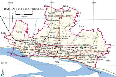
Rajshahi City Corporation

Rajshahi City Corporation area 95.56 sq km, located in between 24°20' and 24°24' north latitudes and in between 88°32' and 88°40' east longitudes. It is bounded by paba upazila on all sides.
Population Total 388811; male 208525, female 180286.
Water bodies Main River: padma.
Administration Rajshahi Municipality was formed in 1876 and it was turned into City Corporation in 1991.
| City Corporation | ||||||||
| City Corporation | Thana | Word | Mahalla | Population | Density (per sq km) | Literacy rate (%) | ||
| 1 | 4 | 33+4 (part) | 170 | 388811 | 4068 | 67.08 | ||
| Thana | ||||||||
| Thana and GO code | Area (sq km) | Ward | Mahalla | Population | Density (per sq km) | Literacy rate (%) | ||
| Boalia 22 | 38.11 | 16+3(Part) | 82 | 191711 | 695 | 71.22 | ||
| Matihar 40 | 20.32 | 5 | 20 | 51724 | 2545 | 63.55 | ||
| Rajpara 85 | 24.90 | 9+1 (Part) | 46 | 121076 | 4862 | 69.70 | ||
| Shah Mokdhum 90 | 12.23 | 3 | 22 | 24300 | 1986 | 63.86 | ||
Source Bangladesh Population Census 2001, Bangladesh Bureau of Statistics.
| Rajshahi City Corporation at a Glance | ||
| Municipality was formed | 1876 | |
| Upgraded to Municipal Corporation | 1987 | |
| Upgraded to City Corporation | 1991 | |
| First Mayor | Abdul Hazi | |
| Current Mayor | AHM Khairuzzaman Liton | |
| Number of holding | 1,15,562 | |
| Population | 388811 | |
| Density of Population | 4068 (per sq km) | |
| Wards | 33+4 (part) | |
| Ward commissioners | 30 | |
| Reserved seats for woman commissioners | 10 | |
| Police Station | 4 | |
| Roads | 186.64 km | |
| Drains | 142.18 km | |
| Park | 2 | |
| Community Center | 7 | |
| Gymnasium | 2 | |
| Graveyard and Cemetery | 4 | |
| Bus Terminals | 1 | |
| Traffic signal | 20 | |
Source Bangladesh Population Census 2001, Bangladesh Bureau of Statistics; Field Reports.
[Tapan Palit]
References Bangladesh Population Census 2001, Bangladesh Bureau of Statistics; Cultural survey report of 2007; Field reports of Rajshahi City Corporation.
