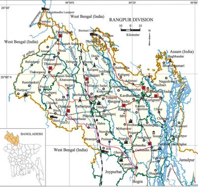
Rangpur Division
Rangpur Division area 16320.26 sq km, located in between 25°20' and 26°37' north latitudes and in between 88°50' and 89°53' east longitudes. It is bounded by west bengal state of India on the north, joypurhat, bogra and jamalpur districts on the south, Assam state of India on the east, West Bengal state of India on the west.
Population Total 13847150; male 51.18%, female 48.82%; Muslim 85.70%, Hindu 13.54%, Buddhist 0.34%, Christian 0.03% and others 0.39%.
Water bodies Main rivers: brahmaputra, jamuna, punarbhaba, karatoya, atrai, tista, mahananda. The biggest irrigation project of the country, Tista Barrage Project (length 615 m) is located at Doani of Hatibandha upazila.
Administration Rangpur Division was formed on 25 January 2010. Rangpur division was declared comprising of 8 districts and 58 upazilas of rajshahi Division.
| Division | ||||||||||
| Area (sq km) |
City corporation | District | Upazila | Paurasabha | Union | Ward | Population | Density (per sq km) |
Literacy rate (%) | |
| Urban | Rural | |||||||||
|
16320.26 |
8 |
58 |
21 |
536 |
204 |
1868314 |
11978836 |
848 |
47.95 | |
| District | |||||||||||
|
Name of District |
Area |
Upazila |
Municipality |
Ward |
Mohalla |
Union |
Mouza |
Village |
Population |
Density |
Literacy rate (%) |
|
Kurigram |
2296.10 |
9 |
2 |
18 |
123 |
73 |
647 |
1903 |
1792073 |
720 |
33.45 |
|
Gaibandha |
2179.27 |
7 |
2 |
18 |
56 |
82 |
1101 |
1243 |
2138181 |
981 |
35.70 |
|
Thakurgaon |
1809.52 |
5 |
2 |
18 |
34 |
51 |
643 |
641 |
1214376 |
671 |
41.80 |
|
Dinajpur |
3437.98 |
13 |
6 |
57 |
208 |
101 |
2020 |
2143 |
2642850 |
769 |
45.70 |
|
Nilphamari |
1580.85 |
6 |
3 |
33 |
68 |
61 |
371 |
370 |
1571690 |
994 |
98.80 |
|
Panchagarh |
1404.63 |
5 |
1 |
9 |
32 |
43 |
463 |
843 |
836196 |
595 |
43.90 |
|
Rangpur |
2370.45 |
8 |
3 |
33 |
203 |
83 |
1215 |
1435 |
2542441 |
1101 |
41.91 |
|
Lalmonirhat |
1241.46 |
5 |
2 |
18 |
86 |
42 |
382 |
876 |
1109343 |
894 |
42.30 |
Source Bangladesh Population Census 2001, Bangladesh Bureau of Statistics.

Religious institutions Mosque 17979, temple 2869, church 60, Buddhist vihara 35, pagoda 24.
Literacy rate and educational institutions Average literacy 47.95%; male 46.15%, female 34.50%. Educational institutions: university 2, open university 1, college 382, veterinary college 1, technical college12, textile institute 1, BAD college 1, vocational training institute 1, vocational textile institute 1, youth training centre 2, primary teachers training institute (PTI) 1, agricultural training institute 1, veterinary resource training institute 1, BPAD collage 1, law college 1, homeopath college 1, secondary school 1836, primary school 5609, community school 131, kindergarten 25, brac school 29, madrasa 1649. Noted educational institutions: Hajee Mohammad Danesh Science and Technology University (2002), Begum Rokeya University' (2008), Rangpur Medical College (1966), Carmichael College (1916), Government Rokeya Mohila College (1964), Teachers Training College, Rangpur Cadet College (1977), Rangpur Zila School (1832), Dinajpur Zila School (1854), Dinajpur Government Girls' High School (1869), Rangpur Government Girls' School (1876), Nilphamari Government High School (1882), Gaibandha Government Boys' High School (1885), Kurigram Government High School (1895), Sayeedpur Pilot Girls' High School (1904), Thakurgaon Zila School (1904), Thakurgaon Government Boys' High School (1904), Lalmonirhat Government High School (1921), Kurigram Girls' High School (1928).
Main sources of income Agriculture 68.50%, non-agricultural labourer 3.88%, industry 0.69%, commerce 11.20%, transport and communication 3.23%, service 3.96%, construction 2.14%, religious service 0.70%, rent and remittance 0.19% and others 5.51%.
Health centres Hospital 11, upazila health complex 37, health and family welfare centre 198, union health centre 158, clinic 90, satellite clinic 75. [Rajib Mondal]
References Bangladesh Population Census 2001, Bangladesh Bureau of Statistics; Cultural survey report of zilas and upazilas of Rajshahi Division 2007.
