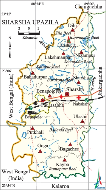
Sharsha Upazila
Sharsha Upazila (jessore district) area 336.28 sq km, located in between 22°55' and 23°12' north latitudes and in between 88°51' and 89°01' east longitudes. It is bounded by west bengal state of India and chaugachha upazila on the north, kalaroa upazila on the south, jhikargachha upazila on the east, West Bengal state of India on the west.
Population Total 341328; male 170033, female 171295; Muslim 332515, Hindu 8443, Buddhist 2, Christian 273 and others 86.
Water bodies Main river: betna; Zila Beel, Sonanadia Beel, Barakona Beel, Banmandar Beel, Kalianir Beel, Balunda Beel and Rantapara' Beel are notable.
Administration Sharsha Thana was formed in 1910 and it was turned into an upazila on 3 July 1983.
| Upazila | ||||||||
| Municipality | Union | Mouza | Village | Population | Density (per sq km) | Literacy rate (%) | ||
| Urban | Rural | Urban | Rural | |||||
| 1 | 11 | 131 | 168 | 41608 | 299720 | 1015 | 59.28 (2001) | 48.7 |
| Municipality | ||||||||
| Area (sq km) |
Ward | Mahalla | Population | Density (per sq km) |
Literacy rate (%) | |||
| - | 9 | 11 | 36524 | - | 56.9 | |||
| Upazila Town | ||||||||
|
Area (sq km) |
Mouza |
Population |
Density (per sq km) |
Literacy rate (%) | ||||
| 14.22 (2001) | 1 | 5084 | 1371 (2001) | 62.6 | ||||
| Union | ||||
| Name of union and GO code | Area (acre) | Population | Literacy rate (%) | |
| Male | Female | |||
| Ulashi 94 | 8622 | 16782 | 16825 | 46.5 |
| Kayba 51 | 7799 | 15320 | 15530 | 47.2 |
| Goga 43 | 7544 | 13013 | 12948 | 44.5 |
| Dihi 34 | 8537 | 11785 | 12372 | 50.7 |
| Nizampur 69 | 6288 | 10488 | 10696 | 47.6 |
| Putkhali 77 | 7291 | 14002 | 13809 | 46.5 |
| Bagachra 08 | 7133 | 16955 | 17295 | 52.4 |
| Bahadurpur 17 | 8171 | 12160 | 12096 | 49.7 |
| Benapole 25 | 5348 | 9002 | 9055 | 49.1 |
| Lakshmanpur 60 | 6460 | 9835 | 10031 | 44.8 |
| Sharsha 86 | 7786 | 22214 | 22591 | 54.3 |
Source Bangladesh Population Census 2001 and 2011, Bangladesh Bureau of Statistics.

Archaeological heritage and relics Patbari Hindu Asram.
War of Liberation During the war of liberation 12 freedom fighters were killed in an encounter with the Pak army at Kagajpukur near the Benapole Border. Besides, the Pak army sacked three nearby villages. There are 2 memorial monuments in the upazila. The tomb of Bir Srestha nur mohammad sheikh is located at village Kashipur in Dihi Union.
For details: see শার্শা উপজেলা, বাংলাদেশ মুক্তিযুদ্ধ জ্ঞানকোষ (Encyclopedia of Bangladesh War of Liberation), বাংলাদেশ এশিয়াটিক সোসাইটি, ঢাকা ২০২০, খণ্ড ৯।
Religious institutions Mosque 175, temple 8, church 2.
Literacy rate and educational institutions Average literacy 49.8%; male 51.6%, female 48.0%. Noted educational institutions: Navaran Degree College (1972), Burung Bagan Secondary School (1942), Navaran High School (1952).
Newspapers and periodicals Sharsha Barta (defunct); literary periodical:' Orbachin.
Cultural organisations Library 1, club 25, cinema hall 3, playground 48, jatra party 4, women's organisation 1.
Main sources of income Agriculture 66.32%, non-agricultural labourer 3.99%, industry 0.94%, commerce 12.40%, transport and communication 3.60%, service 4.43%, construction 1.51%, religious service 0.14%, rent and remittance 0.66% and others 6.01%.
Ownership of agricultural land Landowner 53.44%, landless 46.56%; agricultural landowner: urban 40.06% and rural 53.51%.'
Main crops Paddy, jute, potato, wheat, mustard,' musur, sesame, vegetables.
Extinct or nearly extinct crops Maskalai, linseed.
Main fruits Mango, jackfruit, plum, coconut, hog plum, date.
Fisheries, dairies and poultries Fishery 372, dairy 139, poultry 85.
Communication facilities Pucca road 180.6 km, semi-pucca road 85.9 km, mud road 856.6 km; railway 13 km.
Extinct or nearly extinct traditional transport Palanquin, horse carriage.
Noted manufactories Rice mill, flour mill, ball pen factory, steel mill, textile mill, biscuit factory, ice factory, comb and button factory.
Cottage industries Goldsmith, blacksmith, potteries, embroidery.
Hats, bazars and fairs Hats and bazars are 30, fairs 2, most noted of which are Sharsha Hat, Navaran Hat, Benapole Hat, Bagachra Hat, Ulashi Hat, Lakshmanpur Hat, Nizampur Hat, Tengra Hat, Kayba Hat, Kashipur Hat, Goga Hat and Bahadurpur Hat.
Main exports Date molasses, sesame, vegetables.
Access to electricity All the unions of the upazila are under rural electrification net-work. However 57.6% of the dwelling households have access to electricity.
Sources of drinking water Tube-well 96.2%, tap 1.1% and others 2.7%.
Sanitation 60.2% of dwelling households of the upazila use sanitary latrines and 33.4% of dwelling households use non-sanitary latrines; 6.4% of households do not have latrine facilities.
Health centres Upazila health complex 1, satellite clinic 1, health and family planning centre 11.
NGO activities Operationally important NGOs are brac, asa. [Md. Abdul Khaleque]
References Bangladesh Population Census 2001 and 2011, Bangladesh Bureau of Statistics; Cultural survey report of Sharsha Upazila 2007.
