St Martin's Island
St Martin’s Island a small island in the northeast of the bay of bengal, about 9 km south of the Cox’s Bazar-Teknaf peninsular tip and forming the southernmost part of Bangladesh. It is about 8 km west of the northwest coast of Myanmar at the mouth of the river naf. The island lies between 92°18' and 92°21'E longitudes and 20°34' and 20°39'N latitudes. The local people call it Narikel Jinjira. It is almost flat and is 3.6m above the mean sea level. The 9.66 km wide channel between the mainland and the island is much shallower than the open sea southwest of the island. There are reefs from 10-15 km to the west-northwest.

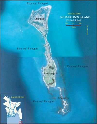
The island is 7.315 km long and is aligned NNW and SSE. Geographically, it is divided into three parts. The northern part is called Narikel Jinjira or Uttarpara and is 2,134m long and 1,402m wide. The southern part is known as Dakshinpara, which is 1,929m long, with a narrow tail of 1,890m towards the southeast, and a maximum width of 975m. A narrow central belt or Maddhyapara connects the two parts. The length and the width of this belt are about 1,524m and 518m respectively and the narrowest collar is known as Golachipa. In addition to the main island there are a number of tiny islets ranging from 100 to 500 sq m which are locally known as Chheradia or Siradia which means separated island.
There is a shallow lagoon in the middle of Uttarpara and it is connected to the sea during high tide by a narrow channel on the western coast. The topsoil of Uttarpara consists of alluvial sands mixed with shells of molluscs. There are two small dead lagoons and a stretch of marshy land in Dakshinpara. Fish landing sites, bazars and schools are present only in Uttarpara.
Launches and country boats ply between the island and teknaf regularly. The population is about 3,700 and most of them are fishermen belonging to 535 families. One hundred eighty-two species of wildlife are recorded from the island. Of these, 4 species are amphibians, 28 reptiles, 130 birds and 20 mammals. tourism to the northern part of the island exists during four months (November to February). The most densely populated part is Jinjira. There is scarcity of sweet water on the island. Only a few ponds and a number of tubewells supply sweet water for drinking as well as for cultivation. Though the island falls in the monsoon zone, the climate is much influenced by the sea. The main vegetation is coconut, betel nut and bamboo. Coconut trees are abundant and more concentrated in the Jinjira area. The soil of the island is not so fertile. The main agricultural products are onion, watermelon and some rice.
The geological structure of the island is simple and is represented by an anticlinal uplift. A little of the axis of the anticline is traceable along the west coast of Dakshinpara. The exposed portion of the axis runs NNW to SSE, approximately parallel to the island. There is a fault along the northwestern shoreline with a trend nearly parallel to the axis. St Martin's limestone is composed of molluscan coquina horizons (shelly limestone) and coral clusters (coralline limestones). Being very porous and permeable, the shelly limestone provides an excellent aquifer wherever they occur beneath the alluvium. Recent marine sands and the shelly limestone are the chief source of fresh water.

Several living small coral colonies are found in small sheltered pools very near the low tide level around the island. They also occur in the surrounding shallow sea, mostly growing on the beach rocks and calcareous sandstone concretions. The dead coral colonies also occur in pool-like depressions within the high and low tide levels. Some of them are located at an elevation of nearly 3.50m above the low tide level. The oldest fossil coral belongs to Late Pleistocene, giving an age of 33,238 years (C14 dating). The clearest indication of the Holocene upliftment of the island is the appearance of an emerged 3.0m coquina limestone cliff on the coast of Dakshinpara ranging in age from 450 years at the base to 292 years at the top (C14 dating). The mean uplifting rate of the island, calculated from the above data, is 19.0 mm/year. The location of the cliff is 1.5m above the present high tide level and on the eastern upthrown faulted block.
The emerged dead corals characterised by Porites sp, Acropora sp, Cyphostrea sp, and Platygyrn sp provide evidence of lower level emergence, ie, they have been raised above the level at which they are at present forming/living. The radiocarbon dates from emerged dead corals are recorded below the ultra low level liquid scintillator's detection limit (ie 0 BP). This suggests that the dead corals have emerged fairly recently, indeed are still in the process of emerging. This means that the environment of St Martin's Island is now not favourable for the growth and development of the only coral island of the country that started forming at least since the last maximum glacial age (ca 40,000 years ago). [Sifatul Quader Chowdhury]
