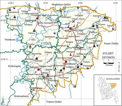
Sylhet Division
Sylhet Division area 12635.24 sq km, located in between 23°58' and 25°12' north latitudes and in between 90°56' and 92°30' east longitudes. It is bounded by Meghalaya state of India on the north, tripura state of India on the south, assam state of India on the east, netrokona and kishoreganj districts on the west.
Population Total 9550722; male 4754567, female 4796155; Muslim 8167788, Hindu 1348180, Buddhist 1188, Christian 21931 and others 11635.
Water bodies Main rivers: surma, kushiyara, Khoai, manu.
Administration Sylhet Division was formed on 1 August 1995. Sylhet City Corporation was formed comprising 27 wards in 2002.'
| Division | ||||||||||
| Area (sq km) |
City corporation | District | Upazila | Paurasabha | Union | Ward | Population | Density (per sq km) |
Literacy rate (%) | |
| Urban | Rural | |||||||||
| 12635.24 | 1 | 4 | 38 | 19 | 332 | 171 | 1435452 | 8115270 | 784 | 45.0 |
| District | |||||||||||
|
Name of District |
Area |
Upazila |
Municipality |
Ward |
Mahalla |
Union |
Mouza |
Village |
Population |
Density |
Literacy rate (%) |
| Maulvibazar 58 | 2799.38 | 7 | 5 | 45 | 151 | 67 | 917 | 2015 | 1919062 | 686 | 51.1 |
| Habiganj 36 | 2574.7 | 8 | 5 | 54 | 188 | 75 | 1127 | 2120 | 2023603 | 786 | 40.5 |
| Sylhet 91 | 3217.28 | 12 | 5 | 36 | 111 | 94 | 1450 | 2915 | 3232834 | 1005 | 51.2 |
| Sunamganj 90 | 3526.12 | 11 | 4 | 36 | 139 | 83 | 1502 | 2738 | 2375223 | 674 | 35.0 |
Source Bangladesh Population Census 2001 and 2011, Bangladesh Bureau of Statistics.

Religious institutions Mosque 7524, temple 1070, church 65, sacred place 2, pagoda 9, tomb 50.
Literacy rate and educational institutions Average literacy 45.0%; male 47.0%, female 43.1%. Educational institutions: university 6, medical college 4, polytechnic institute 5, teachers training college 5, college 129, law college 2, sanskrit college 1, vocational training institute 2, secondary school 780, primary school 5726, community school 88, music school 8, satellite school 208, madrasa 522. Noted educational institutions: shahjalal university of science and technology, Leading University, Sylhet MAG Osmani Medical College, MC College, Maulvibazar Government College (1956), Sreemangal Government College, Habiganj Government Bindaban College, Sunamganj Government College (1944), Sylhet Government Pilot High School, Agragami Government Girls' High School, Maulvibazar Government High School, Kali Prasad High School (1895), Kashinath Alauddin High School (1917), Abul Fazal Chowdhury High School, BTRI High School and College, Habiganj Government High School,' Sunamganj Government Jubilee High School (1887).
Main sources of income Agriculture 51.34%, non-agricultural labourer 8.52%, industry 1.56%, commerce 11.82%, transport and communication 2.13%, construction 1.41%, religious service 0.43%, service 5.67%, rent and remittance 5.16% and others 11.96%.
Health centres Hospital and clinic 62, upazila health complex 36, union health and family planning centre 86, infectious diseases hospital 3, mother and child welfare centre 6, mission hospital 4, family welfare centre 42, satellite clinic 38, veterinary hospital 12. [Sajahan Miah]
References Bangladesh Population Census 2001 and 2011, Bangladesh Bureau of Statistics; field report of districts and upazilas of Sylhet Division 2007.
