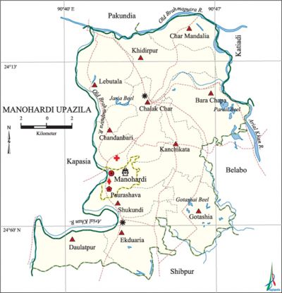
Monohardi Upazila
Monohardi Upazila (narsingdi district) area 193.87 sq km, located in between 24°04' and 24°15' north latitudes and in between 90°38' and 90°49' east longitudes. It is bounded by pakundia and katiadi upazilas on the north, shibpur upazila on the south, belabo and Katiadi upazilas on the east, kapasia upazila on the west.
Population Total 275112; male 131316, female 143796; Muslim 262302, Hindu 12732, Buddhist 17, Christian 6 and others 55.
Water bodies Main rivers: old brahmaputra, arial khan; Gotashia Beel, Jaria Beel and Parail Beel are notable.
Administration Monohardi Thana, now an upazila, was formed in 1904.
| Upazila | ||||||||
| Municipality | Union | Mouza | Village | Population | Density (per sq km) | Literacy rate (%) | ||
| Urban | Rural | Urban | Rural | |||||
| 1 | 11 | 124 | 165 | 21422 | 253690 | 1419 | 53.3 (2001) | 48.9 |
| Municipality | ||||||||
| Area (sq km) |
Ward | Mahalla | Population | Density (per sq km) |
Literacy rate (%) | |||
| - | 9 | 12 | 17635 | - | 63.9 | |||
| Upazila Town | ||||||||
|
Area (sq km) |
Mouza |
Population |
Density (per sq km) |
Literacy rate (%) | ||||
| 6.83 (2001) | 3 | 3787 | 1770 (2001) | 50.5 | ||||
| Union | ||||
| Name of union and GO code | Area (acre) | Population | Literacy rate (%) | |
| Male | Female | |||
| Ekduaria 54 | 4523 | 13770 | 14971 | 51.8 |
| Kanchikata 67 | 4804 | 11389 | 12660 | 46.9 |
| Khidirpur 74 | 5078 | 13640 | 14998 | 48.4 |
| Gotashia 61 | 5121 | 11866 | 13280 | 47.6 |
| Chandanbari 33 | 2446 | 6675 | 7660 | 58.1 |
| Char Mandalia 40 | 3731 | 12696 | 13548 | 40.4 |
| Chalak Char 27 | 2446 | 9295 | 10126 | 48.6 |
| Daulatpur 47 | 3552 | 9679 | 10573 | 53.6 |
| Bara Chapa 21 | 5425 | 13327 | 14205 | 47.2 |
| Lebutala 81 | 5132 | 11395 | 12747 | 49.9 |
| Shukundi 94 | 4279 | 8975 | 10002 | 51.0 |
Source Bangladesh Population Census 2001 and 2011, Bangladesh Bureau of Statistics.

Archaeological heritage and relics Single domed mosque at Mia Bari (1890), mosque of Abdul Hai Maulvi at Shukundi (1900).
Historical events On 29 December 1968, during the mass upsurge, the police opened fire on the agitated general public who were picketing and organizing processions at Hatirdia Bazar (during hartal) in which five persons were killed and many were wounded.
War of Liberation During the war of liberation in 1971 the freedom fighters launched a surprise attack on the Pak army stationed at the Monohardi High School Camp in which 5 Pakistani soldiers were killed. The freedom fighters had kept the camp under their control for some time. In the middle of August an encounter between the freedom fighters and the Pak army was held at village Doshdona under Shukundi union in which 4 Pak soldiers were killed. in retaliation next day, the Pak army sacked the whole village.
For details: see মনোহরদী উপজেলা, বাংলাদেশ মুক্তিযুদ্ধ জ্ঞানকোষ (Encyclopedia of Bangladesh War of Liberation), বাংলাদেশ এশিয়াটিক সোসাইটি, ঢাকা ২০২০, খণ্ড ৭।
Religious institutions Mosque 645, temple 26, tomb 2. Noted religious institutions: Bilagi Mia-Bari Mosque, Abdul Hai Maulvi Mosque at Shukundi, Narandi Ashok Molla Mosque, Asadnagar Mazar, Monohardi Pagal Nath Ashrama.
Literacy rate and educational institutions Average literacy 49.9%; male 49.7%, female 50.2%. Noted educational institutions: Hatirdia Rajiuddin College (1972), Khidirpur College (1987), Khidirpur High School (former George Mary Academy, 1912), Chalak Char High School (1933), Hatirdia Sadat Ali Model High School (1941), Monohardi High School (1948), LK Union High School (1950), Shekergaon Senior Madrasa, Dharabanda Fazil Madrasa (1926), Dasdona Islamia Fazil Madrasa (1930).
Newspapers and periodicals Defunct: daily Grameen Darpan (1984), weekly: Mashal (1987).
Cultural organisations Club 68, auditorium 1, cinema hall 2, playground 40.
Main sources of income Agriculture 64.78%, non-agricultural labourer 2.4%, industry 0.73%, commerce 11.81%, transport and communication 2.72%, service 7.04%, construction 0.9%, religious service 0.19%, rent and remittance 2.8% and others 6.63%.
Ownership of agricultural land Landowner 71.36%, landless 28.64%; agricultural landowner: urban 58.26% and rural 72.04%.
Main crops Paddy, jute, wheat, sugarcane, betel leaf, garlic, vegetables.
Extinct or nearly extinct crops Sesame, kaun, linseed, ground-nut, arahar.
Main fruits Mango, jackfruit, litchi, banana, papaya.
Fisheries, dairies and poultries Fishery 1 dairy 32, poultry 300, hatchery 1. cattle breeding centre 4.
Communication facilities Pucca road 311 km, semi-pucca road 4.47 km, mud road 254 km.
Extinct or nearly extinct traditional transport Palanquin, horse carriage, bullock cart.
Cottage industries Blacksmith, weaving, potteries, wood work.
Hats, bazars and fairs Hats and bazars are 27, fairs 5, most noted of which are Hatirdia Hat, Monohardi Hat, Chalak Char Hat, Sagardi Hat and Monohardi Khalpar Mela.
Main exports Jute, banana, betel leaf, garlic, vegetables.
Access to electricity All the wards and unions of the upazila are under rural electrification net-work. However 56.7% of the dwelling households have access to electricity.
Sources of drinking water Tube-well 96.8%, tap 0.5% and others 2.7%.
Sanitation 55.1% of dwelling households of the upazila use sanitary latrines and 31.0% of dwelling households use non-sanitary latrines; 13.9% of households do not have latrine facilities.
Health centres Upazila health complex 1, satellite clinic and family planning centre 7, Bradley Burt Charitable Hospital at Monohardi (1921).
NGO activities Operationally important NGOs are brac, asa. [Md. Iftekhar Uddin Bhuiyan]
References Bangladesh Population Census 2001 and 2011, Bangladesh Bureau of Statistics; Cultural survey report of Monohardi Upazila 2007.
