Katrabo
Katrabo a Pargana and a city of medieval Bengal. It was the fortified residence and the capital of isa khan, established sometime before 1585. The Mughal Subahdar shahbaz khan destroyed this city during the war of the Mughals against the bara-bhuiyans. Subsequently, Afgan Chief masum khan kabuli rebuilt part of the city and Katrabo was under his control till his death in 1598. musa khan, son of Isa Khan, stationed his general Daud Khan at Katrabo against the advance of Islam Khan;. On 12 March 1611, the Mughal General Mirza Nathan defeated Daud Khan and destroyed the fort of Katrabo.

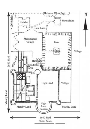
The remains of Katrabo can still be seen in Masumabad village (of Rupganj upazila in Narayanganj district) on the eastern bank of river Shitalaksya, near the Bahadur Khan bil. Part of 'Diwan Badi' (the residence of the Diwans), and the sweet-water tank inside its compound, called Mitha Puskarini, the tank called 'Diwan Dighi' (Tank or Pond located on the northeast corner of Diwan Badi) and a ruined tomb on the northern bank of the tank are the surviving remains.
The Diwan Badi (about 434m x 335m) is surrounded by a 0.67m thick brick wall on its south, east and west. At its corners, remains of octagonal turrets can still be seen. The pillared gateway of the enclosure, now in ruins, is situated on the eastern wall. As one enters through the gateway, one cannot but notice an oblong piece of highland, which was possibly the site of the residential quarters. On the southern side of the gateway, adjacent to the wall, there lies another highland, which was possibly a bastion tower. Outside the southern and western boundary wall lies a marshland, about 68m wide. No wall appears to exist on the north of Diwan Badi. However, traces of some ruined pillars mark its northern limit. One of the pillars, which still stand, is 2.33m and 3.33m high. Inside it, a kiln burnt earthen pipe stands vertically. Inside the Diwan Badi compound, on the southern side, lies a paved floor, some 53.34m x 50m.
The Mitha Puskarini (pond), bounded on its four sides with retaining brick walls, is nearly square and about 7m deep. It was used as the source of drinking water of the residents. According to local tradition, a three-domed mosque used to stand on the northern bank of the tank. Traces of brick wall exists on the western bank, which is currently overlain with trees and bushes.
Remains of brick walls have been found beyond the northern boundary of Diwan Badi, up to the area known as Kazi Badi. This area was possibly the residential quarters of high-ranking officers who served the Diwan. On its east, and beyond the northeastern boundary of Diwan Badi, there exists a large tank with a picturesque island in the middle. To the local residents, the tank is known as Diwan Dighi (around 439m x 220m). The island is square in shape, and till 1972, it was connected to the western bank with a causeway.
On the western bank of Diwan Dighi lies a mound (19m x 16m) littered with brickbats. Near it lies a flight of steps of masonry known as Rajghat, which descends into the tank. It is possible that the mound was the site of a public bath.
Inside the walled graveyard, which lies on the northern bank of Diwan Dighi, stands a ruined tomb with a gateway in the middle of its southern side. It is not known who lies buried in it. [Shahnaj Husne Jahan]
