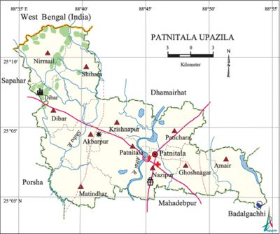
Patnitala Upazila
Patnitala Upazila (naogaon district) area 382.38 sq km, located in between 24°59' and 25°12' north latitudes and in between 88°35' and 88°55' east longitudes. It is bounded by dhamoirhat upazila and west bengal state of India on the north, mahadebpur upazila on the south, badalgachhi upazila on the east, sapahar and porsha upazilas on the west.
Population Total 231900; male 116724, female 115176; Muslim 182190, Hindu 35821, Buddhist 76, Christian 4777 and others 9036. Indigenous communities such as santal, oraon, Mahali and munda belong to this upazila.
Water bodies Main rivers: atrai, shiba.
Administration Patnitala Thana was formed in 1907 and it was turned into an upazila in 1983.
| Upazila | ||||||||
| Municipality | Union | Mouza | Village | Population | Density (per sq km) | Literacy rate (%) | ||
| Urban | Rural | Urban | Rural | |||||
| 1 | 11 | 286 | 298 | 21670 | 210230 | 606 | 69.6 | 50.8 |
| Municipality | ||||||||
|
Area (sq km) |
Ward |
Mahalla |
Population |
Density (per sq km) |
Literacy rate (%) | |||
| 11.82 | 9 | 15 | 21670 | 1833 | 69.6 | |||
| Union | ||||
| Name of union and GO code | Area (acre) | Population | Literacy rate (%) | |
| Male | Female | |||
| Akbarpur 12 | 8431 | 10848 | 10628 | 52.7 |
| Amair 17 | 8416 | 10135 | 10398 | 43.6 |
| Krishnapur 43 | 10238 | 11368 | 11365 | 46.5 |
| Ghoshnagar 34 | 7501 | 10932 | 10942 | 52.1 |
| Dibar 25 | 7785 | 8320 | 8276 | 53.2 |
| Nazipur 60 | 4957 | 6280 | 5982 | 53.8 |
| Nirmail 69 | 9094 | 6554 | 6446 | 47.7 |
| Patnitala 86 | 8660 | 10730 | 10756 | 50.5 |
| Patichara 77 | 7844 | 9961 | 9590 | 57.5 |
| Matindhar 51 | 8717 | 10254 | 10185 | 54.2 |
| Shihara 94 | 9155 | 10104 | 10176 | 47.6 |
Source Bangladesh Population Census 2011, Bangladesh Bureau of Statistics.

Archaeological heritage and relics Dibar Dighi and Vhimer Panyhi (1075), Victory Pillar of Raja Divyak, Amair Dighi, 'Kangan Dighi and Jogir Ghopa are notable.
War of Liberation Freedom fighters had encounters with Pak army at Mahadevpur, Shishugram, Porsha, Sapahar, Patnitala and some other places of the upazila. People still have vivid memory of the fight at Durgapur.
For details: see পত্মীতলা উপজেলা, বাংলাদেশ মুক্তিযুদ্ধ জ্ঞানকোষ (Encyclopedia of Bangladesh War of Liberation), বাংলাদেশ এশিয়াটিক সোসাইটি, ঢাকা ২০২০, খণ্ড ৫।
Religious institutions Mosque 336, temple 147, church 9, sacred place 1.
Literacy rate and educational institutions Average literacy 52.5%; male 54.5%, female 50.5%. Educational institutions: college 4, primary school 122, madrasa 28. Noted educational institutions: Nazipur Government College (1973), Nazipur Mohila College (1995), Katabari High School (1924), Nazipur Pilot High School (1930), Sarlabala (Gandhi) Girls' School (1920), Nazipur Siddiqia Fazil Madrasa (1969).
Cultural organisations Library 1, club 24, theatre group 2, cinema hall 4, women's organisation 1, playground 6.
Main sources of income Agriculture 80.24%, non-agricultural labourer 2.07%, industry 0.70%, commerce 7.75%, transport and communication 2.05%, service 3.64%, construction 0.41%, religious service 0.14%, rent and remittance 0.06% and others 2.94%.
Main crops Paddy, wheat, potato, sugarcane, onion, vegetables.
Extinct or nearly extinct crops Aus paddy, barley, tobacco.
Main fruits Mango, jackfruit, banana, litchi, watermelon.
Fisheries, dairies and poultries Fishery 5, dairy 4, poultry 30, hatchery 2.
Communication facilities Pucca road 165 km, semi-pucca road 18 km, mud road 321 km.
Extinct or nearly extinct traditional transport Palanquin, dhuli, horse carriage, bullock cart.
Noted manufactories Flour mill, rice mill, ice factory, biscuit factory.
Cottage industries Goldsmith, blacksmith, potteries, bamboo work, wood work.
Hats, bazars and fairs Hats and bazars are 29, fairs 12, most noted of which are Madhail Hat, Shibpur Hat, Nazipur Hat, Chaitra Samkranti Mela at Trimohani, Baruni Snan Mela, Kashipur Mela, Padmapukur Mela, Jatnipatni Mela.
Main exports Molasses, paddy, rice, watermelon.
Access to electricity All the wards and unions of the upazila are under electrification net-work. However 35.3% of the dwelling households have access to electricity.
Natural resources Zinc mine (Ambati), lime stone (Chawknirkhin) and China mati (a fine species of porcelain) have been detected in the upazila
Sources of drinking water Tube-well 83.7%, tap 3.6% and others 12.7%.
Sanitation 27.2% of dwelling households of the upazila use sanitary latrines and 32.4% of dwelling households use non-sanitary latrines; 40.4% of households do not have latrine facilities.
Health centres Upazila health complex 1, family planning centre 5, satellite clinic 6, hospital 2, community clinic 6.
NGO activities Operationally important NGOs are caritas, CARE, proshika, brac, asa, thengamara mahila sabuj sangha. [Shamsul Arefin Tuhin]
References Bangladesh Population Census 2001 and 2011, Bangladesh Bureau of Statistics; Cultural survey report of Patnitala Upazila 2007.
