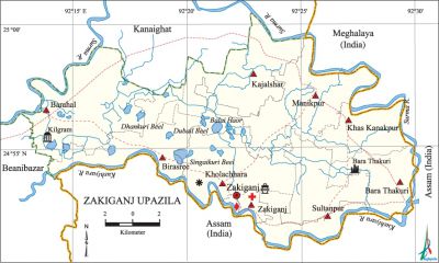
Zakiganj Upazila
Zakiganj Upazila (sylhet district) area 287.33 sq km, located in between 24°51' and 25°00' north latitudes and in between 92°13' and 92°30' east longitudes. It is bounded by kanaighat upazila and Meghalaya state of India on the north, assam state of India on the south and east, beanibazar upazila on the west.
Population Total 198399; male 99822, female 98577; Muslim 177842, Hindu 20513, Christian 10 and others 34.
Water bodies Main rivers: surma, kushiyara; Balai Haor; Dhankuri Beel, Dubail Beel, Singaikuri Beel are notable.
Administration Zakiganj Thana was formed in 1947 and it was turned into an upazila in 1983.
| Upazila | ||||||||
| Municipality | Union | Mouza | Village | Population | Density (per sq km) | Literacy rate (%) | ||
| Urban | Rural | Urban | Rural | |||||
|
1 |
9 |
119 |
276 |
16307 |
182092 |
690 |
48.75 |
44.91 |
| Municipality | |||||
| Area (sq km) | Ward | Mahalla | Population | Density (per sq km) | Literacy rate (%) |
|
6.39 |
9 |
17 |
10762 |
1684 |
53.41 |
| Upazila Town | |||||
|
Area (sq km) |
Mouza |
Population |
Density (per sq km) |
Literacy rate (%) | |
|
9.56 |
3 |
5545 |
582 |
39.39 | |
| Union | ||||
| Name of union and GO code | Area (acre) | Population | Literacy rate (%) | |
| Male | Female | |||
|
Kajalshar 47 |
9708 |
11115 |
10932 |
41.97 |
|
Khas Kanakpur 38 |
4616 |
8274 |
8433 |
45.67 |
|
Kholachhara 57 |
7658 |
9574 |
9273 |
37.48 |
|
Zakiganj 85 |
5349 |
7102 |
6704 |
45.86 |
|
Bara Thakuri 19 |
5111 |
9861 |
9873 |
41.22 |
|
Barahal 15 |
439 |
13994 |
14038 |
42.94 |
|
Birasree 28 |
8268 |
10255 |
9959 |
51.34 |
|
Manikpur 66 |
9884 |
12958 |
12537 |
46.27 |
|
Sultanpur 76 |
5481 |
11157 |
11598 |
49.69 |
Source Bangladesh Population Census 2001, Bangladesh Bureau of Statistics.

Archaeological heritage and relics Nawabi Mosque at Khilgram, Sajid Bazar Mosque, Gayibi Dighi at Bara Thakuri (a stone inscription of 400 years old, now preserved in the Bangladesh national museum, has been discovered from this dighi).
History of the War of Liberation The Pak army entered into Zakiganj in April 1971 for the first time. During the war of liberation the Pak army conducted mass killing and extensive plundering in the upazila; they also set many houses on fire.
Marks of the War of Liberation Mass grave 2 (Atgram Bazar and Kaliganj Bazar)
Religious institutions Mosque 463, temple 73, tomb 9.
Literacy rate and educational institutions Average literacy 45.22%; male 49.97%, female 40.46%. Educational institutions: college 4, secondary school 23, primary school 127, community school 14, kindergarten 4, madrasa 47. Noted educational institutions: Gurusadoy High School (1857), Barahal Ahia High School ((1935), Ichamati Bohumukhi High School (1957), Phultali Alia Madrasa (1920).
Newspapers and periodicals Quaterly: Banshari; defunct: Shishir.
Cultural organizations Library 3, club 8, press club 1, literary society 1, playground 10.
Main sources of income Agriculture 46.06%, non-agricultural labourer 9.06%, industry 0.74%, commerce 12.84%, transport and communication 1.64%, service 5.80%, construction 1.84%, religious service 1.19%, rent and remittance 6.93% and others 13.90%.
Ownership of agricultural land Landowner 51.31%, landless 48.69%; agricultural landowner: urban 44.41% and rural 51.94%.
Main crops Paddy, soybean, vegetables.
Extinct or nearly extinct crops Sesame, mustard, sweet potato.
Main fruits Mango, jackfruit, banana, papaya, betel nut.
Fisheries, dairies and poultries This upazila has a number of fisheries, dairies, poultries and hatcheries.
Extinct or nearly extinct traditional transport Palanquin, horse carriage, bullock cart.
Noted manufactories Rice mill, welding factory.
Cottage industries Goldsmith, weaving, wood work, tailoring.
Hats, bazars and fairs Hats and bazars are 3, most noted of which are Zakiganj Bazar, Kaliganj Bazar and Shahagli Bazar.
Main exports Betel nut, fish.
Access to electricity All the wards and unions of the upazila are under rural electrification net-work. However 17.54% of the dwelling households have access to electricity.
Sources of drinking water Tube-well 36.83%, tap 1.61%, pond 59.81% and others 1.74%. The presence of intolerable level of arsenic has been detected 18.19% in shallow tube-well water of the upazila.
Sanitation 27.44% (rural 25.35% and urban 50.44%) of dwelling households of the upazila use sanitary latrines and 68.68% (rural 70.93% and urban 43.93%) of dwelling households use non-sanitary latrines; 3.88% of households do not have latrine facilities.
Health centres Upazila health centre 1, union health and family welfare centre 10, private hospital 4.
NGO activities Operationally important NGOs is brac. [Md. Abdul Hakim]
References Bangladesh Population Census 2001, Bangladesh Bureau of Statistics; Field report of Zakiganj Upazila 2010.
