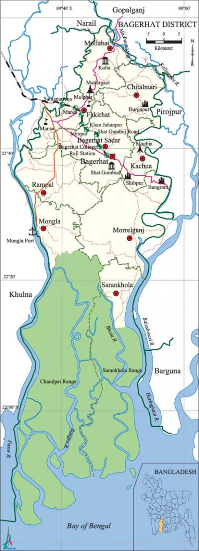
Bagerhat District
Bagerhat District (khulna division) area 3959.11 sq km, located in between 21°49' and 22°59' north latitudes and in between 89°32' and 89°98' east longitudes. It is bounded by gopalganj and narail districts on the north, bay of bengal on the south, Gopalganj, pirojpur and barguna districts on the east, khulna district on the west.
Population Total 1476090; male 740138, female 735952; Muslim 1198593, Hindu 270874, Buddhist 6115, Christian 43 and others 465.
Water bodies Main rivers: pasur, madhumati, Baleshwari, Kaliganga, Haringhata, Bangra, Bhola.
Administration Bagerhat' district was formed in 1984.
| District | |||||||||
| Area (sq km) | Upazila | Municipality | Union | Mouza | Village | Population | Density (per sq km) | Literacy rate (%) | |
| Urban | Rural | ||||||||
| 3959.11 | 9 | 3 | 75 | 703 | 1048 | 195331 | 1280759 | 373 | 59.0 |
| Others Information of District | ||||||||
| Name of upazila | Area (sq km) | Municipality | Union | Mouza | Village | Population | Density (per sq km) | Literacy rate (%) |
| Kachua | 131.63 | - | 7 | 80 | 102 | 97011 | 737 | 56.8 |
| Chitalmari | 191.99 | - | 7 | 55 | 124 | 138810 | 723 | 56.2 |
| Fakirhat | 160.68 | - | 8 | 67 | 87 | 137789 | 858 | 62.0 |
| Bagerhat Sadar | 272.73 | 1 | 10 | 164 | 189 | 266389 | 977 | 63.6 |
| Mongla | 1461.20 | 1 | 6 | 28 | 83 | 136588 | 93 | 57.2 |
| Morrelganj | 460.90 | 1 | 16 | 120 | 181 | 294576 | 639 | 60.7 |
| Mollahat | 187.88 | - | 7 | 59 | 103 | 130878 | 697 | 50.0 |
| Rampal | 335.45 | - | 10 | 118 | 134 | 154965 | 462 | 58.0 |
| Sarankhola | 756.60 | - | 4 | 12 | 45 | 119084 | 157 | 58.9 |
Source Bangladesh Population Census 2011,Bangladesh Bureau of Statistics.

War of Liberation During the war of liberation in 1971 Bagerhat district was under sector 9. On 21 April the Pak army killed about 200 persons at Khalishakhali and Babuganj Bazar. 35 freedom fighters were killed in an encounter between the freedom fighters and the razakars at Morrelganj. The razakars also killed more than one hundred people in Terabaka canal of Sharankhola upazila. On 3 May the Pak army killed 42 persons at Shakharikathi Hat in Badhal union of Kachua upazila. On May 21 the razakars killed many people and set many houses on fire in Rampal upazila. The Pak army, in collaboration with the razakars, captured 9 persons from village Mansha of Bahirdia union of Fakirhat upazila on 25 August and 70 persons from Basha Bazar of Moghia union of Kachua upazila on 15 October and killed all of them at a place near Bhasarhat Bridge. During the War of Liberation, about 200 Pakistani soldiers including one Captain were killed in a battle between the freedom fighters and the Pak army at Chakulia (Charkulia) of Mollahat upazila. There are mass graves at 9 places (Chitalmari, Sakharikathi, Morelganj, Ranjitpur, Teligati, Dakra, Kandapara, Mansha Bazar, Maghia) and mass killing sites at 4 places of the district; 8 memorial monuments have been built.
Literacy rate and educational institutions Average literacy 59.0%; male 60.0%, female 58.0%. Educational institutions: college 44, technical college 2, vocational institutions 1, secondary school 241, technical school 2, primary school 873, kindergarten 10, community school 3, madrasa 222. Noted educational institutions: Rampal Degree College (1968), Khalilur Rahman Degree College (1968), Sarankhola Degree College (1978), Shaheed Smriti Degree College (1993), Kachua Degree College, Kachua Mahila Degree College, Homeopathic College, PC College (1918), Mongla College (1981), Government Mahila College, Khan Jahan Ali College, Physical Education College, Textile Institute, Mongla Bandar School and College (1987), Prafulla Chandra Ray Higher Secondary School (1918), Medical Assistant Training School, Blind-Deaf Institute, Mulghar Government High School (1857), Bagerhat Multilateral High School (1878), Bahirdia High School (1892), Naldha High School (1895), AC Laha Pilot High School (1924), Gilatala Multilateral High School (1929), Daibagnyahati Bisheshor Multilateral Secondary School (1915), Moshni Secondary School (1915), Goalhat Rasiklal Multilateral Secondary School (1916), Sachidaha Chunkhola MB Secondary School (1916), Chingrakhali Secondary School (1920), Khan Jahania Secondary School (1923), Kachubunia Rahmatia Secondary School (1927), Sugandhi Secondary Girl's School (1930), Failahat Kamaluddin Secondary School (1937), Perikhali Union Secondary School (1939), Dakra Multilateral High School (1940), SM High School (1945), Saint Paul's High School (1954), RKDS Girl's School (1968), Charlatia Government Primary School (1904), Bara Baria Hatkhola Government Primary School (1912), Angra Government Primary School (1918), Madartali Government Model Primary School (1928), Madhabkathi Ahmadia Fazil Degree Madrasa (1915).
Main sources of income Agriculture 54%, non-agricultural labourer 6.7%, industry 0.87%, commerce 17.28%, transport and communication 3.3%, service 8.05%, construction 1.32%, religious service 0.28%, rent and remittance 0.4% and others 7.8%.
Newspapers and periodicals Daily: Dakshin Kantha, Uttayal, Dakhin Bangla, Dut; weekly: Khan Jahan, Bagerhat Darpan, Bagerhat Barta.
Folk culture Charagan, dazzles, proverbs, Meyeli geet (folk songs sung by women on different festivals), Gazir geet, Aushtok songs sung on Chaitra Samkranti are notable.
Tourist spots shatgumbad mosque, Saint Paul's Church, tomb of Khan Jahan Ali, Durgapur Shiva Math, Rajbari of Banagram, Mongla Bandar, Karamjal of sundarbans and Hiron Point, Sundarban Museum. [HM Khaled Kamal]
See also The upazilas under this district.
References Bangladesh Population Census 2001 and 2011, Bangladesh Bureau of Statistics; Cultural survey report of Bagerhat District 2007; Cultural survey report of different upazilas of Bagerhat District 2007.
