Burhanuddin Upazila
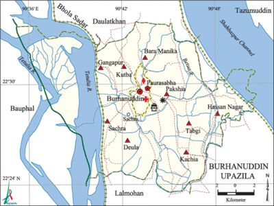
Burhanuddin Upazila (bhola district) area 284.67 sq km, located in between 22°21' and 22°34' north latitudes and in between 90°35' and 90°51' east longitudes. It is bounded by bhola sadar and daulatkhan upazilas on the north, lalmohan on the south, tazumuddin upazila on the east, bauphal upazila on the west.
Population Total 244137; male 125828, female 118309; Muslim 230900, Hindu 13174, Buddhist 14 and others 49.
Water bodies Main rivers: tentulia, Betua, Gangapur; Deula beel and Meghna-Shabazpur channel are notable.
Administration Burhanuddin Thana was formed in 1928 and it was turned into an upazila on 15 April 1983.
| Upazila | ||||||||
| Municipality | Union | Mouza | Village | Population | Density (per sq km) | Literacy rate (%) | ||
| Urban | Rural | Urban | Rural | |||||
|
1 |
9 |
57 |
58 |
35657 |
208480 |
858 |
50.9 |
34.7 |
| Municipality | ||||||||
|
Area |
Ward |
Mahalla |
Population |
Density |
Literacy rate (%) | |||
|
3.27 |
9 |
13 |
9604 |
2937 |
57.95 | |||
| Upazila Town | ||||||||
|
Area (sq km) |
Mouza |
Population |
Density |
Literacy rate (%) | ||||
|
25.66 |
3 |
26053 |
1015 |
48.18 | ||||
| Union | ||||
| Name of union and GO code | Area (acre) | Population | Literacy rate (%) | |
| Male | Female | |||
|
Kachia 47 |
7209 |
15703 |
15448 |
40.00 |
|
Kutba 57 |
5884 |
11550 |
11242 |
43.24 |
|
Gangapur 28 |
12996 |
13956 |
10561 |
30.01 |
|
Tabgi 95 |
6338 |
13647 |
13238 |
37.13 |
|
Deula 19 |
6195 |
10638 |
11305 |
26.42 |
|
Pakshia 66 |
6433 |
16328 |
14973 |
36.43 |
|
Bara Manika 16 |
7172 |
17389 |
16824 |
39.43 |
|
Sachra 76 |
5254 |
10568 |
10566 |
23.14 |
|
Hassan Nagar 38 |
5693 |
10977 |
9620 |
45.94 |
Source Bangladesh Population Census 2001, Bangladesh Bureau of Statistics.

Archaeological heritage and relics Mosque of Burhanuddin Chowdhury Bari, Talukdar Bari at Deula, Dighi of Mangal, Revenue office of Saji, Maniram Math.
History of the War of Liberation During the war of liberation in 1971 encounters between the freedom fighters (under Siddiqur Rahman) and the Pak army were held in villages Sachra and Deula. On 22 October the Pak army set many houses of the villages Tetulia, Betua and Deula on fire. Siddiqur Rahman with his compatriots attacked the Pak army at Deula Dighir Par in which about 50 Pak soldiers including their collaborator, Officer in Charge (OC) of the Thana, were killed. On 29 October the freedom fighters attacked Burhanuddin Police Station, and later on the Pak army entered into the villages and killed many people indiscriminately.
Marks of the War of Liberation Memorial monument 1 (in front of the upazila complex).
Religious institutions Mosque 457, temple 25.
Literacy rate and educational institutions Average literacy 37.2%; male 40%, female 34.2%. Educational institutions: college 2, secondary school 31, primary school 146, community primary school 1, kindergarten 4, NGO school 70, madrasa 110. Noted educational institutions: Abdul Jabber College (1972), Burhanuddin Mohila Degree College (1995), Burhanuddin High School (1917), Mirzakalu High School (1920), Kutba Secondary School (1988), Burhanuddin Alia Madrasa (1921).
Newspapers and periodicals Monthly: Palli Chitra; wall magazine; Deyalika (irregular)|
Cultural organisations Library 1, club 205, theatre group 3, cinema hall 3, playground 57, literary academy 1.
Main sources of income Agriculture 66.37%, non-agricultural labourer 4.09%, commerce 11.29%, transport and communication 2.65%, industry 0.35%, service 6.14%, construction 2.05%, religious service 0.37%, rent and remittance 0.98% and others 5.71%.
Ownership of agricultural land Landowner 59.89%, landless 40.11%; agricultural landowner: urban 58.96% and rural 60.06%.
Main crops Paddy, jute, potato, ground nut, pulses, sugarcane, chilli, betel leaf, vegetables.
Extinct or nearly extinct crops Sesame, linseed, mustard seed.
Main fruits Mango, jackfruit, watermelon, papaya, banana, betel nut, coconut, futi.
Fisheries, dairies and poultries Fishery 46, dairy 1, poultry 38, hatchery 47.
Communication facilities Roads: pucca 185.87 km, semi-pucca 15.30 km, mud road 260.2 km.
Extinct or nearly extinct traditional transport Palanquin, bullock cart.
Noted Manufactories Flour mill, saw mill, oil mill.
Cottage industries Goldsmith, blacksmith, weaving, potteries, bamboo work, wood work.
Hats, bazars and fairs Hats and bazars are 30, fairs 3, most noted of which are Burhanuddin Hat, Mirzakalu Hat, Raniganj Hat, Khayer Hat, Charak Mela and Chaitra Songkranti Mela.
Main exports Paddy, jute, betel leaf, betel nut, chilli, fish.
Access to electricity All the wards and unions of the upazila are under rural electrification net-work. However 8.66% (rural 5.99% and urban 23.34%) dwellings have access to electricity.
Natural resources Natural gas (Shabazpur).
Sources of drinking water Tube-well 70.63%, tap 0.11%, pond 2.82% and others 26.44%.
Sanitation 27.75% (rural 23.03% and urban 53.75%) of dwelling households of the upazila use sanitary latrines and 63.24% (rural 67.70% and urban 38.69%) of dwelling households use non-sanitary latrines; 9.01% of households do not have latrine facilities.
Health centres Upazila health complex 1, family planning centre 8, veterinary hospital 1.
NGO activities brac, proshika, asa. [Sayed Mustaba Ahmad Khan]
References Bangladesh Population Census 2001, Bangladesh Bureau of Statistics; Cultural survey report of Burhanuddin Upazila 2007.
