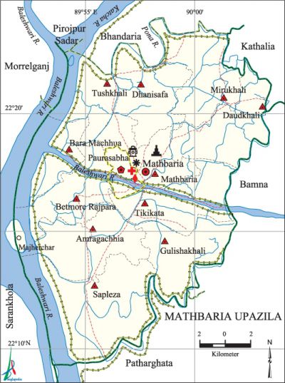
Mathbaria Upazila
Mathbaria Upazila (pirojpur district) area 344.23 sq km, located in between 22°09' and 22°24' north latitudes and in between 89°52' and 90°03' east longitudes. It is bounded by pirojpur sadar and bhandaria upazilas on the north, patharghata upazila on the south, bamna and kanthalia upazilas on the east, sarankhola and morrelganj upazilas on the west.
Population Total 262841; male 128845, female 133996; Muslim 236344, Hindu 26307, Buddhist 137, Christian 26 and others 27.
Water bodies Main rivers: Baleshwari, katcha, Pona.
Administration Mathbaria Thana, now an upazila, was formed in 1981.
| Upazila | ||||||||
| Municipality | Union | Mouza | Village | Population | Density (per sq km) | Literacy rate (%) | ||
| Urban | Rural | Urban | Rural | |||||
| 1 | 11 | 67 | 93 | 28851 | 233990 | 764 | 69.7 (2001) | 60.5 |
| Municipality | ||||||||
|
Area (sq km) |
Ward |
Mahalla |
Population |
Density (per sq km) |
Literacy rate (%) | |||
| 6.55 (2001) | 9 | 16 | 18375 | 2352 (2001) | 77.9 | |||
| Upazila Town | ||||||||
|
Area (sq km) |
Mouza |
Population |
Density (per sq km) |
Literacy rate (%) | ||||
| 15.92 (2001) | 3 | 10476 | 653 (2001) | 61.2 | ||||
| Union | ||||
| Name of union and GO code | Area (acre) | Population | Literacy rate (%) | |
| Male | Female | |||
| Amragachhia 15 | 8658 | 10013 | 11077 | 63.4 |
| Gulishakhali 51 | 7692 | 10521 | 10575 | 61.5 |
| Tikikata 86 | 8737 | 12284 | 13301 | 62.2 |
| Tushkhali 94 | 4727 | 8918 | 8969 | 53.6 |
| Daudkhali 34 | 7984 | 10272 | 10711 | 60.4 |
| Dhanisafa 43 | 8135 | 14280 | 13926 | 62.4 |
| Bara Machhua 17 | 4172 | 5794 | 6014 | 52.5 |
| Betmore Rajpara 25 | 6663 | 9597 | 10276 | 56.3 |
| Mathbaria 60 | 7841 | 10788 | 11279 | 62.2 |
| Mirukhali 69 | 8552 | 11266 | 12136 | 61.6 |
| Sapleza 77 | 11902 | 15988 | 16481 | 62.3 |
Source Bangladesh Population Census 2011, Bangladesh Bureau of Statistics.

Archaeological heritage and relics Sonakhali Zamindar Bari, Kuthibari at Sapleza.
Historical events During the period from 1830 to 1870 peasant movements were held against the Ijaradars in protest of imposing enhanced rents at Tushkhali.
War of Liberation In the month of May 1971 the razakars killed 12 freedom fighters at Jhatipunia. Freedom fighters did not have any encounter with Pak army in the upazila but the y organized resistance against entry of Pakistani soldiers in the area and also, carried out operations in the neighboring upazilas. A mass killing site has been discovered in the upazila.
For details: see মঠবাড়িয়া উপজেলা, বাংলাদেশ মুক্তিযুদ্ধ জ্ঞানকোষ (Encyclopedia of Bangladesh War of Liberation), বাংলাদেশ এশিয়াটিক সোসাইটি, ঢাকা ২০২০, খণ্ড ৭।
Religious institutions Mosque 720, temple 20, sacred place 1. Noted religious institutions: Bandar Jami Mosque, Safa Jami Mosque, Mathbaria Hari Mandir.
Literacy rate and educational institutions Average literacy 61.7%; %; male 61.7%, female 61.7%. Educational institutions: college 2, secondary school 35, primary school 158, madrasa 182. Noted educational institutions: Mathbaria Government Degree College, Mohiuddin Mohila College, KM Latif Institution (1928), Gulishakhali GK Union High School, Bara Machhua United High School, Noli Bhim Chandra Secondary School (1928).
Newspapers and periodicals Fortnightly: Mathbaria Samachar.
Cultural organisations Library 5, club 19, cinema hall 1, theatre group 1.
Main sources of income Agriculture 59.89%, non-agricultural labourer 4.49%, commerce 12.81%, transport and communication 1.86%, service 7.10%, construction 1.36%, religious service 0.24%, rent and remittance 2.13% and others 10.12%.
Ownership of agricultural land Landowner 65.16%, landless 34.84%; agricultural landowner: urban 54.04% and rural 66.32%.'
Main crops Paddy, wheat, sugarcane, pulse, vegetables.
Extinct or nearly extinct crops Betel leaf, jute, sesame, mustard.
Main fruits Mango, coconut, jackfruit, banana, betel nut, hog-plum.
Communication facilities Pucca road 162 km, semi-pucca road 201 km, mud road 620 km; waterway 62 km.
Extinct or nearly extinct traditional transport Palanquin.
Noted manufactories Ice factory, saw mill, rice mill.
Cottage industries Blacksmith, weaving, potteries, bamboo work, bidi factory, welding factory.
Hats, bazars and fairs Hats and bazars are 31, fairs 3, most noted of which are Mathbaria Hat, Tushkhali Hat, Bara Machhua Hat and Pahela Baishakh Mela (Port at Mathbaria).
Main exports Betel nut, coconut.
Access to electricity All the wards and unions of the upazila are under rural electrification net-work. However 34.7% of the dwelling households have access to electricity.
Sources of drinking water Tube-well 37.3%, tap 4.5% and others 58.2%.
Sanitation 58.2% of dwelling households of the upazila use sanitary latrines and 40.1% of dwelling households use non-sanitary latrines; 1.7% of households do not have latrine facilities.
Health centres Hospital 1, rural health centre 49, satellite clinic 2, family planning centre 7.
NGO activities Operationally important NGOs are brac, proshika, asa, Jubuk, Songram, Sold, Hido. [Md. Mizanur Rahman]
References Bangladesh Population Census 2001 and 2011, Bangladesh Bureau of Statistics; Cultural survey report of Mathbaria Upazila 2007.
