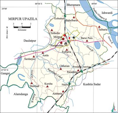
Mirpur Upazila
Mirpur Upazila (kushtia district) area 317.35 sq km, located in between 23°45' and 24°00' north latitudes and in between 88°50' and 89°06' east longitudes. It is bounded by bheramara and ishwardi upazilas on the north, alamdanga and kushtia sadar upazilas on the south, Kushtia Sadar upazila on the east, daulatpur (Kushtia), gangni and Alamdanga upazilas on the west.
Population Total 285089; male 146636, female 138453; Muslim 278757, Hindu 6252 and others 80. Indigenous communities such as Kol, Buno belong to this upazila.
Water bodies Main rivers: padma, kumar, Gorai; Sagorkhali Canal is notable.
Administration Mirpur Thana was formed in 1885 and it was turned into an upazila on 1 August 1983.
| Upazila | ||||||||
| Municipality | Union | Mouza | Village | Population | Density (per sq km) | Literacy rate (%) | ||
| Urban | Rural | Urban | Rural | |||||
|
1 |
12 |
122 |
187 |
27406 |
257683 |
898 |
48.5 |
35.9 |
| Municipality | ||||||||
|
Area (sq km) |
Ward |
Mahalla |
Population |
Density (per sq km) |
Literacy rate (%) | |||
|
8.81 |
9 |
15 |
18835 |
2138 |
46.2 | |||
| Upazila Town | ||||||||
|
Area (sq km) |
Mouza |
Population |
Density (per sq km) |
Literacy rate (%) | ||||
|
3.54 |
2 |
8571 |
2421 |
53.5 | ||||
| Union | ||||
| Name of union and GO code | Area (acre) | Population | Literacy rate (%) | |
| Male | Female | |||
|
Ambaria 13
|
3573
|
7864
|
7755
|
38.44
|
|
Amla 14
|
6735
|
12819
|
11898
|
41.81
|
|
Kursha 58
|
5886
|
9411
|
9081
|
30.66
|
|
Chithulia 43
|
7542
|
13970
|
13136
|
35.14
|
|
Chhatian 36
|
6282
|
11703
|
11117
|
35.22
|
|
Talbaria 94
|
4771
|
9672
|
8881
|
37.03
|
|
Poradaha 80
|
6962
|
17218
|
16192
|
40.17
|
|
Fulbaria 73
|
5331
|
6203
|
5771
|
35.73
|
|
Bahalbaria 21
|
4464
|
11506
|
10788
|
38.63
|
|
Barui Para 29
|
6784
|
12411
|
11943
|
42.914
|
|
Malihad 65
|
7500
|
11049
|
10495
|
24.07
|
|
Sardarpur 87
|
7394
|
12917
|
12454
|
33.58 |
Source Bangladesh Population Census 2001, Bangladesh Bureau of Statistics.

Religious institutions Mosque 280, temple 18, tomb 1. Noted religious institutions: Al Musharraf Jami Mosque, Bahubaria Old Jami Mosque, Khadimpur Bazar Mosque, Temple of the Dhingha Babu at Babupara of Poradaha, Sadarpur Mandir, Mirpur Pauro Mandir, tomb of Abdur Rahman.
Literacy rate and educational institutions Average literacy 37.1%; male 39.2%, female 34.9%. Educational institutions: college 12, secondary school 33, primary school 124, satellite school 3, madrasa 9, maktab 30. Noted educational institutions: Mirpur Mahmuda Chowdhury Degree College' (1986), Mirpur Degree College (1999), Amla Sadarpur Secondary School (1899), Mirpur Pilot High School (1913), Poradaha High School (1927), Mirpur Government Pilot Girls' High School (1983).
Newspapers and periodicals Monthly: Auronoday; periodical: Protidhoni.
Cultural organisations Library 6, women's organisation 7, cinema hall 1.
Main sources of income Agriculture 66.54%, non-agricultural labourer 2.90%, industry 1.08%, commerce 13.23%, transport and communication 3.35%, service 4.75%, construction 1.29%, religious service 0.17%, rent and remittance 0.36% and others 6.33%.
Ownership of agricultural land Landowner 53.76%, landless 46.24%; agricultural landowner: urban 38.62% and rural 55.34%.
Main crops Paddy, wheat, jute, sugarcane, potato, tobacco, mustard, betel leaf, sunflower.
Extinct or nearly extinct crops Sesame, linseed.
Main fruits Mango, blackberry, banana, jackfruit.
Fisheries, dairies and poultries Fishery 35, dairy 9, poultry 5, hatchery 4.
Communication facilities Pucca road 106.79 km, semi-pucca road 112.2 km, mud road 442.54 km; railway 35 km; waterway 1.07 nautical miles.
Extinct or nearly extinct traditional transport Palanquin, horse carriage, bullock cart.
Noted manufactories Rice mill, cotton mill, sugar mill, bidi factory, welding factory.
Cottage industries Goldsmith, blacksmith, weaving, bamboo work, cane work, wood work.
Hats, bazars and fairs Hats and bazars are 12, fairs 3, most noted of which are Mirpur Cattle Market, Khadimpur Hat, Poradaha Cloth Market, Baishakhi Mela at Hajarhati Village.
Main exports Tobacco, jute, betel leaf.
Access to electricity All the wards and unions of the upazila are under rural electrification net-work. However 29.55% of the dwelling households have access to electricity.
Sources of drinking water Tube-well 94.04%, tap 0.48%, pond 0.21% and others 5.27%.
Sanitation 34.12% (rural 32.20% and urban 52.50%) of dwelling households of the upazila use sanitary latrines and 36.41% (rural 36.61% and urban 34.43%) of dwelling households use non-sanitary latrines; 29.47% of households do not have latrine facilities.
Health centres Upazila health complex 1, clinic 13, family planning and welfare centre 10.
Natural disasters Many people were victims of the floods and cyclones of 1823, 1837, 1864, 1867, 1871, 1887, 1900, 1930, 1938, 1948, 1954, 1961, and 1971; these natural disasters also caused heavy damages to settlements and crops of the upazila. Besides, many people were also victims of the famine of 1943.
NGO activities Operationally important NGOs are brac, asa, BRDB, Swanirvar Bangladesh, Shetu, Jagarani. [Arif Nishir]
References Bangladesh Population Census 2001, Bangladesh Bureau of Statistics; Cultural survey report of Mirpur Upazila 2007.
