Patgram Upazila
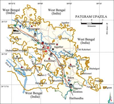
Patgram Upazila (lalmonirhat district) area 246.85 sq km, located in between 26°17' and 26°33' north latitudes and in between 89°03' and 89°21' east longitudes. It is bounded by west bengal state of India on the north, east and west, hatibandha upazila and West Bengal state of India on the south. This upazila has 27 enclaves of which Dahagram and Angarpota are the most noted enclaves of the country. The Tin Bigha Corridor connects these two enclaves with the main land.
Population Total 218615; male 110712, female 107903; Muslim 208130, Hindu 10480, Buddhist 1, Christian 2 and others 2.
Water bodies Main rivers: tista, Singimari.
Administration Patgram Thana was formed in 1801 and it was turned into an upazila on 18 March 1984.
| Upazila | ||||||||
| Municipality | Union | Mouza | Village | Population | Density (per sq km) | Literacy rate (%) | ||
| Urban | Rural | Urban | Rural | |||||
| 1 | 8 | 45 | 46 | 30565 | 188050 | 886 | 49.7 | 45.5 |
| Municipality | ||||||||
|
Area (sq km) |
Ward |
Mahalla |
Population |
Density (per sq km) |
Literacy rate (%) | |||
| 12.49 | 9 | 23 | 30565 | 2447 | 49.7 | |||
| Union | ||||
| Name of union and GO code | Area (acre) | Population | Literacy rate (%) | |
| Male | Female | |||
| Kuchlibari 54 | 5519 | 8861 | 8728 | 39.2 |
| Jagatber 27 | 9096 | 14228 | 14073 | 44.1 |
| Jongra 40 | 8122 | 13285 | 12998 | 49.2 |
| Dahagram 19 | 4617 | 5075 | 4965 | 35.5 |
| Patgram 67 | 9007 | 14377 | 13889 | 48.1 |
| Baura 13 | 7123 | 14208 | 14231 | 46.8 |
| Burimari 15 | 6376 | 12728 | 11991 | 44.6 |
| Sreerampur 81 | 8053 | 12459 | 11954 | 48.1 |
Source Bangladesh Population Census 2011, Bangladesh Bureau of Statistics.

Archaeological heritage and relics Dhabalsati Mosque, Jamgram Jami Mosque, Pateshwari Temple at Patgram, Mota' Sannyasi Statue.
War of Liberation Burimari under Patgram upazila was the headquarters of Sector 6 during the war of liberation. The upazila was ‘liberated area’ during the War of Liberation and the freedom fighters of the upazila took part in operations and encounters in the neighboring upazilas and districts. An auditorium named after martyr Afzal has been built in Patgram.
For details: see পাটগ্রাম উপজেলা, বাংলাদেশ মুক্তিযুদ্ধ জ্ঞানকোষ (Encyclopedia of Bangladesh War of Liberation), বাংলাদেশ এশিয়াটিক সোসাইটি, ঢাকা ২০২০, খণ্ড ৫।
Religious institutions Mosque 352, temple 25, church 2. Noted religious institutions: Jamgram Jami Mosque, Rasul Pir Tomb, Pateshwari Temple.
Literacy rate and educational institutions Average literacy 46.1%; male 48.4%, female 43.8%. Educational institutions: college 3, secondary school 27, primary school 88, madrasa 42. Noted educational institutions: Jasimuddin Government Kazi Abdul Gani Degree College (1968), Patgram Mohila Degree College (1997), Patgram Model Degree College (1998), Patgram Taraknath High School (1945), Baura Public High School (1945), Burimari Hasar Uddin High School (1955),' Jongra National High School (1967), Patgram Huzur Uddin Government Girls' High School (1968), Mirzacourt HM High School (1972), Patgram NP Senior Madrasa (1962).
Cultural organisations Library 37, club 126, cinema hall 2, stadium 1, playground 6.
Tourist spots Tin Bigha Corridor and Burimari Land Port.
Main sources of income Agriculture 74.22%, non-agricultural labourer 4.45%, industry 0.29%, commerce 9.12%, transport and communication 2.34%, service 2.62%, construction 0.55%, religious service 0.26%, rent and remittance 0.15% and others 6%.
Main crops Paddy, tobacco, wheat, potato, jute, ground nut.
Extinct or nearly extinct crops Kaun, sweet potato, mustard.
Main fruits Mango, jackfruit, black berry, betel nut.
Communication facilities Roads: pucca 99 km, semi-pucca 9 km, mud road 562 km; railway 38 km.
Extinct or nearly extinct traditional transport Palanquin, bullock cart.
Noted manufactories Flour mill, ice factory, toffee factory, welding factory.
Cottage industries Goldsmith, blacksmith, wood work.
Hats, bazars and fairs Hats and bazars are 16, fairs 8, most noted of which are Baura Hat, Patgram Hat, Beltali Hat, Rasulganj Hat, Munsir Hat, Pateshwari Mela, Barunir Mela and Durgapujar Mela.
Main exports Paddy, jute, tobacco, potato, betel nut.
Access to electricity All the wards and unions of the upazila are under rural electrification net-work. However 19.2% of the dwelling households have access to electricity.
Natural resources High quality sand and stone-chip have been discovered in this upazila.
Sources of drinking water Tube-well 0.2%, tap 94.6% and others 5.2%.
Sanitation 38.2% of dwelling households of the upazila use sanitary latrines and 44.5% of dwelling households use non-sanitary latrines; 17.3% of households do not have latrine facilities.
Health centres Upazila health complex 1, union health centre 3, clinic 1.
NGO activities Operationally important NGOs are brac, proshika, [[Rangpur Dinajpur Rural Service|rangpur dinajpur rural service], Swanirvar Bangla, Jagarani. [Benu Begum Bijli]
References Bangladesh Population Census 2001 and 2011, Bangladesh Bureau of Statistics; Cultural survey report of Patgram Upazila 2007.
