Rainfall
Rainfall water that is condensed from the aqueous vapour in the atmosphere and falls in drops from the sky to the earth is called rain; and the total amount of rain that falls in a particular area within a certain time is called rainfall. The rainfall in Bangladesh varies, depending upon season and location. Winter (November through February) is very dry and accounts for only less than 4% of the annual rainfall. Rainfall in this season varies from 20 mm in the west and south to 40 mm in the northeast, which is caused by the westerly disturbances that enter the country from the northwestern part of India.

Rainfall in the pre-monsoon hot season (March-May) accounts for 10-25% of the total annual rainfall. The rain in this period is caused by convective storms (thunderstorms) or nor'westers (locally called Kalbaishakhi). Average rainfall of this season varies from 200 mm in the west-central part of the country to 800 mm in the northeast. Enhanced rainfall in the northeast is caused by the additional effect of the orographic uplifting provided by the Meghalaya plateau.
The rainy season (June through October) accounts for 70 to 85% of the annual rainfall, which varies from 70% in the eastern part of the country to about 80% in the southwest, and 85% in the northwest. The amount of rainfall during this season varies from 1000 mm in the west-central part of the country to over 2000 mm in the south and northeast. Rainfall in this season is caused by weak tropical depressions that are brought from the bay of bengal into Bangladesh by the wet monsoon winds. Again, higher rainfall in the northeast is caused by the additional uplifting effect of the Meghalaya plateau. After the withdrawal of the wet monsoon, which usually occurs in mid-October, rainfall diminishes at a rapid pace.
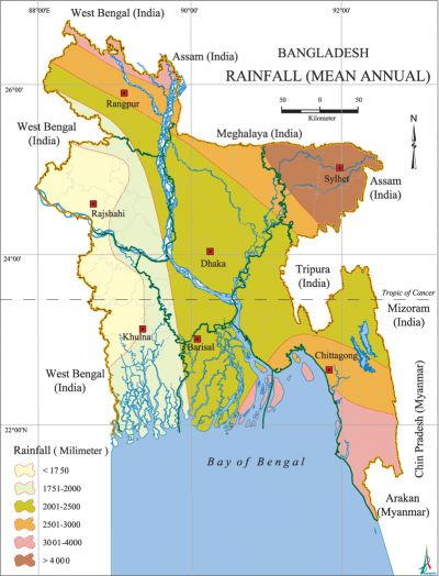
The average annual rainfall in Bangladesh varies from 1500 mm in the west-central part to over 3000 mm in the northeast and southeast. In Surma Valley and neighbouring hills, the rainfall is very high. At Sylhet the rainfall average is 4180 mm, near the foot of the abrupt Meghalaya Plateau at Sunamganj it is 5330 mm, and at Lalakhal 6400 mm, the highest in Bangladesh. Cherapunji, barely 16 km across the border in a straight line to the north of Chhatak upazila, records an astonishing average of 10,820 mm annually. [Rafique Ahmed]
