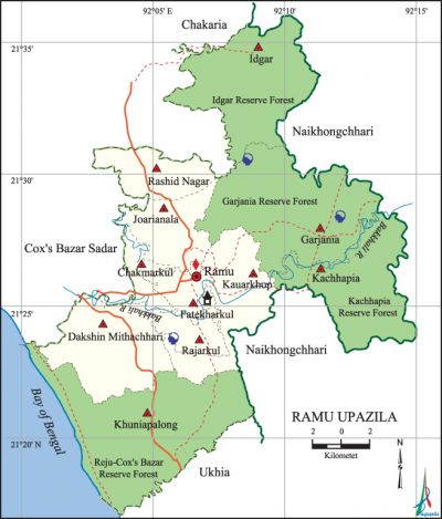
Ramu Upazila
Ramu Upazila (cox’s Bazar district) area 391.71 sq km, located in between 21°17' and 21°36' north latitudes and in between 92°00' and 92°15' east longitudes. It is bounded by chakaria and cox’s bazar sadar upazilas on the north, naikhongchhari and ukhia upazilas on the south, Naikhongchhari upazila on the east, Cox's Bazar Sadar and the bay of bengal on the west.
Population Total 266640; male 135000, female 131640; Muslim 248766, Hindu 8745, Buddhist 8916, Christian 44 and others 169.
Water bodies Main river: Bakkhali.
Administration Ramu Thana was formed in 1908 and it was turned into an upazila in 1983.
| Upazila | ||||||||
| Municipality | Union | Mouza | Village | Population | Density (per sq km) | Literacy rate (%) | ||
| Urban | Rural | Urban | Rural | |||||
| - | 11 | 39 | 102 | 42072 | 224568 | 681 | 47.2 | 34.5 |
| Upazila Town | ||||||||
|
Area (sq km) |
Mouza |
Population |
Density (per sq km) |
Literacy rate (%) | ||||
| 22.03 | 3 | 42072 | 1910 | 47.2 | ||||
| Union | ||||
| Name of union and GO code | Area (acre) | Population | Literacy rate (%) | |
| Male | Female | |||
| Idgar 28 | 12865 | 9105 | 9210 | 34.7 |
| Kachhapia 47 | 10770 | 14310 | 14026 | 32.9 |
| Kauarkhop 66 | 6144 | 12024 | 11980 | 33.7 |
| Khuniapalong 57 | 19018 | 18497 | 17818 | 28.1 |
| Garjania 19 | 15929 | 11232 | 11419 | 33.0 |
| Chakmarkul 13 | 1802 | 8686 | 7752 | 46.1 |
| Joarianala 38 | 8411 | 13621 | 13702 | 33.6 |
| Dakshin Mithachhari 85 | 10088 | 13166 | 12832 | 36.0 |
| Fatekharkul 15 | 2435 | 15608 | 14961 | 52.8 |
| Rashid Nagar 70 | 4245 | 8369 | 8169 | 35.8 |
| Rajarkul 76 | 5087 | 10382 | 9771 | 37.0 |
Source Bangladesh Population Census 2011, Bangladesh Bureau of Statistics.

Archaeological heritage and relics Hindu Temple and Buddhist Keyang at Ramkot, Buddhist Keyang at Lamarpara.
War of Liberation About 50 freedom fighters of the upazila took part in a direct encounter with the Pakistani soldiers at Idgarh on 25 November 1971. 16 Pakistani soldiers were killed and among the freedom fighters, one was martyred and 5 were injured.
For details: see রামু উপজেলা, বাংলাদেশ মুক্তিযুদ্ধ জ্ঞানকোষ (Encyclopedia of Bangladesh War of Liberation), বাংলাদেশ এশিয়াটিক সোসাইটি, ঢাকা ২০২০, খণ্ড ৯।
Religious institutions Mosque 282, temple 16, keyang and pagoda 20. Noted religious institutions: Ramu Jami Mosque, Eidgah Bazar Mosque, Ramkot Hindu Temple, Shree Shree Ramdevi Purna Mandir, Ramkot Buddhist Keyang, Lamarpara Buddhist Keyang.
Literacy rate and educational institutions Average literacy 36.6%; male 37.8%, female 35.3%. Educational institutions: college 1, secondary school 38, primary school 82, kindergarten 6, madrasa 19. Noted educational institutions: Ramu Khijari Model High School (1914).
Cultural organisations Library 2, club 14, cultural organisation 2, playground 13, women organisation 7.
Tourist spots Ramkot (Hindu and Buddhist sacred place), Rubber Garden, Thoienga Chowdhury Keyang at Lamarpara.
Main sources of income Agriculture 47.01%, non-agricultural labourer 12.52%, industry 0.82%, commerce 13.06%, transport and communication 2.99%, service 5.10%, construction 1.10%, religious service 0.25%, rent and remittance 0.75% and others 16.40%.
Ownership of agricultural land Landowner 33.41%, landless 66.59%; agricultural landowner: urban 32.67% and rural 37.46%.'
Main crops Paddy, potato, pulse, onion, garlic, ginger, betel leaf, rubber, vegetables.
Extinct or nearly extinct crops Sugarcane, sesame, linseed, mustard, cotton, jute.
Main fruits Mango, jackfruit, pineapple, banana, papaya, coconut, betel nut.
Fisheries, dairies and poultries Fishery 15, dairy 2, poultry 8, hatchery 10.
Communication facilities Pucca road 15.36 km, semi-pucca road 69.9 km, mud road 367.92 km.
Extinct or nearly extinct traditional transport Palanquin, horse carriage, bullock cart.
Noted manufactories Rice mill, flour mill, saw mill, ice factory, welding factory.
Cottage industries Goldsmith, blacksmith, potteries, weaving, bell metal work, brass work, bamboo work, cane work, wood work, tailoring.
Hats, bazars and fairs Hats and bazars are 32, fairs 2, most noted of which are Ramu Bazar, Kauarkhop Bazar, Panirchhara Bazar, Garjania Bazar, Eidgar Bazar, Joaria Nala Bazar, Fakir Hat Bazar and Ramkot Mela.
Main exports Betel leaf, betel nut, coconut, banana, papaya, jackfruit, pineapple, shrimp, rubber.
Access to electricity All the unions of the upazila are under rural electrification net-work. However 23.7% of the dwelling households have access to electricity.
Sources of drinking water Tube-well 97.6%, tap 1.7% and others 0.7%.
Sanitation 51.4% of dwelling households of the upazila use sanitary latrines and 31.4% of dwelling households use non-sanitary latrines; 17.2% of households do not have latrine facilities.
Health centres Upazila health complex 2, family planning centre 9, clinic 2.
Natural disasters Many people were victims of the cyclone of 1991. Besides, it also caused heavy damages to settlements, livestock and crops of the upazila.
NGO activities Operationally important NGOs are brac, proshika, asa, CARE, caritas. [Muhammad Tawhid Hossain Chowdhury]
References Bangladesh Population Census 2001 and 2011, Bangladesh Bureau of Statistics; Cultural survey report of Ramu Upazila 2007.
