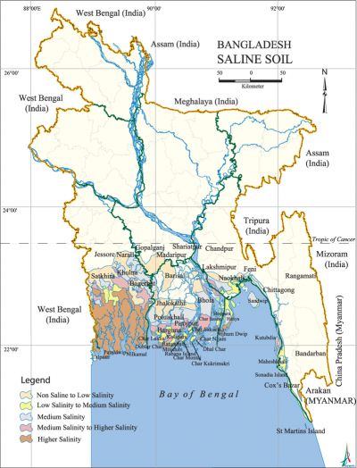
Saline Soil
Saline Soil contains an excess of soluble salts, especially sodium chloride. In other words, soils that develop under the influence of the electrolyte of sodium salts, with a nearly neutral reaction. Dominant salts are sodium chloride and sodium sulphate, but seldom sodium nitrate, magnesium sulphate, or magnesium chloride. They are non-sodic soils containing soluble salts in such quantities that they interfere with the growth of most crop plants. The amount of the soluble salts in a soil is expressed in terms of percentage or parts per million, or other convenient units like EC in mS/cm or mmhos/cm. The pH of the saturated saline soil is usually less than 8.3. These soils are geographically associated with arid, semi-arid, sub-humid and humid areas as well.

The estimates indicate that Bangladesh has about 1.06 million ha of land affected by salinity in 2009. The total area includes deltaic floodplains and offshore islands. This comes to about one fifth of the total areas of Bangladesh and lies around the northern apex of the bay of bengal. The saline soils are mainly found in Khulna, Barisal, Patuakhali, Noakhali, Chittagong, Laxmipur, Feni, Satkhira, Pirajpur, Barguna, Bagerhat, Bhola, Cox's Bazar, Jessore, Magura, Narail, Faridpur, Gopalganj, Jhalkati districts of the coastal and offshore lands.
Due to a number of environmental factors the coastal soils are slightly to moderately saline on the surface, and highly saline in sub-surface layers and substrata. The process of accumulation of salts in the soil is called salinisation. There are a number of factors responsible for the salinisation of an area, particularly a coastal area, depending on its situation. The land relief and degree of flooding have mainly affected the formation of coastal saline soils of Bangladesh. The other factors are: i) the nature of the soil, ii) precipitation, iii) tidal action, iv) the effect of the river system and their discharges, v) depth of the groundwater table and salt deposits, and vi) the slope of the ground and the proximity to drainage channels.
Floodplain deposits commonly have clay minerals in variable mixtures of kaolinite and illite while Ganges tidal and riverine and young Meghna estuarine sediments have a large amount of montmorillonite in addition. It is shown from the difference between precipitation and evaporations during the wet and dry seasons that the net negative evaporation during the dry season causes the salinisation of the surface layer of the coastal soil. The coastal area is affected by cyclonic storms often accompanied by seawater inundation. The tidal range varies from zero at the Cape of Cameron to about 6 m at the north point of Bay of Bengal. Such inundation impregnates the soils with soluble salts. The principal rivers flowing through the coastal belt are the ganges; its distributaries like the gorai-madhumati and Baleshwar are vital for keeping the state of salinity to tolerable limits in different regions. Studies reveal that a maximum of 5,000 cusec of steady fresh water in the Gorai are required to hold the salinity of Khulna zone below 1,000 B5mhos/cm level. It is probable that any reduction in the meghna's present flow of 250,000 cft/sec will cause significant saline intrusion problems.
The coastal soils are slightly to moderately saline but salinity during the dry season increases. The highly silty estuarine floodplains have high salinity values for both the topsoil and substratum. The sundarbans soils are mainly moderately saline to saline in the east and highly saline (20-56 B5mhos/cm) in the west. Soil salinity is lowest in the northeast and gradually increases towards the west. It shows an upward trend in February and reaches a maximum level in April-May. After June it declines sharply whereas the water salinity shows an even steeper fall. [Md Khurshid Alam]
