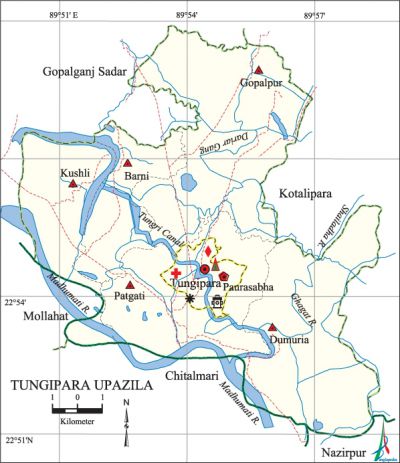
Tungipara Upazila
Tungipara Upazila (gopalganj district) area 128.53 sq km, located in between 22°50' and 23°01' north latitudes and in between 89°48' and 89°57' east longitudes. It is bounded by gopalganj sadar and kotalipara upazilas on the north, chitalmari and nazirpur upazilas on the south, Kotalipara' upazila on the east, Gopalganj Sadar and mollahat upazilas on the west.
Population Total 100893; male 50517, female 50376; Muslim 71370, Hindu 29427, Christian 86, Buddhist 1 and others 9.
Water bodies Main river: madhumati, Ghagat, Dariar Gang and Shailadaha. Tungri Canal is notable.'
Administration Tungipara Thana was formed in 1974 and it was turned into an upazila in 1995. Tungipara Municipality was formed in 1997.
| Upazila | ||||||||
| Municipality | Union | Mouza | Village | Population | Density (per sq km) | Literacy rate (%) | ||
| Urban | Rural | Urban | Rural | |||||
| 1 | 5 | 33 | 67 | 38020 | 62873 | 785 | 55.1 (2001) | 55.3 |
| Municipality | |||||
|
Area (sq km) |
Ward |
Mahalla |
Population |
Density |
Literacy rate (%) |
| 2.57 | 9 | 13 | 8596 | 3345 | 63.0 |
| Upazila Town | |||||
|
Area (sq km) |
Mouza |
Population |
Density |
Literacy rate (%) | |
| 30.39 (2001) | 9 | 29424 | 1009 (2001) | 57.5 | |
| Union | ||||
| Name of union and GO code | Area (acre) | Population | Literacy rate (%) | |
| Male | Female | |||
| Kushli 66 | 4018 | 7378 | 7555 | 47.3 |
| Gopalpur 38 | 9164 | 7630 | 7250 | 59.3 |
| Dumuria 28 | 7454 | 10417 | 10281 | 58.9 |
| Patgati 76 | 7256 | 13962 | 14170 | 58.7 |
| Barni 19 | 3233 | 6760 | 6894 | 51.7 |
Source Bangladesh Population Census 2001 and 2011, Bangladesh Bureau of Statistics.

War of Liberation On 19 May 1971, the Pak army raided the residence of Bangabandhu sheikh mujibur rahman at Tungipara. On the same day the Pak army killed Sheikh Mithu, Arshad Ali, Torab Ali, Dhala Miah Sardar and Liku. The Pakistani soldiers also set on fire many houses of Tungipara. During the war of liberation the local razakars established a camp in the residence of Bangabandhu. On 11 July the freedom fighters (Hemayet Bahini) launched an attack on the camp; the razakars were defeated and were driven away. Freedom fighters had an encounter with Pak army at Patgati of the upazila. Freedom fighters had also carried out an operation on a steamer carrying collaborators of the Pak army from Khulna to Dhaka and had arrested them.
For details: See টুঙ্গিপাড়া উপজেলা, বাংলাদেশ মুক্তিযুদ্ধ জ্ঞানকোষ (Encyclopedia of Bangladesh War of Liberation), বাংলাদেশ এশিয়াটিক সোসাইটি, ঢাকা ২০২০, খণ্ড ৪।
Religious institutions Mosque 136,' temple 243, tomb 1.
Literacy rate and educational institutions Average literacy 56.6%; male 57.2%, female 56.0%. Educational institutions: college 2, secondary school 18,' primary school 65, kindergarten 4, madrasa 5, maktab 124. Noted educational institutions: Sheikh Mujibur Rahman Degree College (1986), Dr. Emdadul Haq Memorial College, Nilfa Baira High School (1917), Gimadanga Tungipara Govt. High School (1966), Gopalpur Pancha Palli High School, Bangabandhu Memorial Girls High School, Banchbaria Jhanjhania High school, Ghaohar Danga Khademul islam Madrasa.
Cultural organisations Library 3, club 21, cinema hall 1, cultural organisation 2, playground 13, women organisation 29, krira Organisation 5, youth organization 12.
Main sources of income Agriculture 70.08%, non-agricultural labourer 2.19%, commerce 11.36%, transport and communication 0.99%, service 8.82%, construction 0.58%, religious service 0.41%, rent and remittance 0.35% and others 5.22%.
Ownership of agricultural land Landowner 69.99%, landless 30.01%; agricultural landowner: urban 58.26% and rural 76.73%.'
Main crops Paddy, jute, wheat, mustard, sweet potato, pulse, ground nut, sunflower, betel leaf, sugarcane, rubber, vegetables.
Extinct or nearly extinct crops Sesame, linseed.
Main fruits Mango, jackfruit, banana, papaya, coconut, palm, guava, lemon, litchi.
Fisheries, dairies and poultries Chingri ghers 1596, dairy 17, poultry 68, hatchery 2.
Communication facilities Pucca road 145 km, semi-pucca road 28 km, mud road 130 km; waterway 10 km.
Extinct or nearly extinct traditional transport Palanquin.
Noted manufactories Bakery factory, ice factory, brick field.
Cottage industries Goldsmith, blacksmith, potteries, weaving, nakshi kantha, nakshi pankha, bamboo work, cane work, different kind of net, mat work (with date leaf).
Hats, bazars and fairs Patgati Hat, Tungipara Hat, Nilfa Hat, Banchbaria Hat, Kushli Hat, Tharial Hat, Basuria Hat, Gimadanga Hat, Singipara Hat, Dumuria Hat, Labutala Hat, Barni Hat and Ghohardanga Mela, Joaria Mela, Dumuria Mela and Gopalpur Mela ara notable.
Main exports Jute, palm molasses, wheat, sweet potato, vegetables.
Access to electricity All the wards and unions of the upazila are under rural electrification net-work. However 61.1% of the dwelling households have access to electricity.
Natural resources Pit coal has been detected in the Barnir Baor area of the upazila.
Sources of drinking water Tube-well 78.6%, tap 15.4% and others 6.0%. The presence of arsenic has been detected in 81% of the shallow tube well water of the upazila.
Sanitation 92.1% of dwelling households of the upazila use sanitary latrines and 6.4% of dwelling households use non-sanitary latrines; 1.5% of households do not have latrine facilities.
Main tourists spot Bangabandhu Mausoleum Complex at Tungipara.
Health centres Hospital 1, Upazila health complex 1, family planning centre 5, satellite clinic 2.
Natural disasters Many people were victims of the cyclone of 1991. Besides, it also caused heavy damages to settlements, livestock and crops of the upazila.
NGO activities Operationally important NGOs are brac, proshika, asa, CARE, caritas, World Vision, CCDB. [Poritosh Haldar]
References Bangladesh Population Census 2001 and 2011, Bangladesh Bureau of Statistics; Cultural survey report of Tungipara Upazila 2007.
