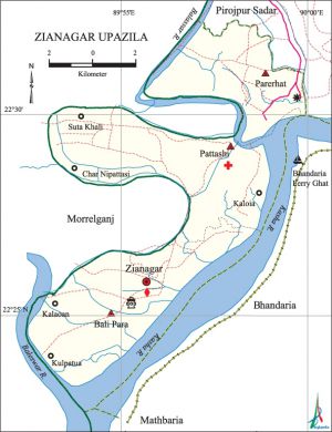
Zianagar Upazila
Zianagar Upazila (pirojpur district) area 91.78 sq km, located in between 22°31' and 22°40' north latitudes and in between 90°01' and 90°07' east longitudes. It is bounded by pirojpur sadar upazila on the north, mathbaria and bhandaria upazila on south, Pirojpur Sadar and Bhandaria upazilas on the east, morrelganj upazila and Baleswar River on the west.
Population Total 71905; male 36119, female 35786; Muslim 65128, Hindu 6756, Buddhist 3, Christian 14 and others 4.
Water bodies Main rivers: Kasha and Baleswar.
Administration Indurkani thana was formed in 1976 comprising Parerhat, Bali Para and Pattashi unions of Pirojpur Sadar upazila. On 21 April 2002 Indurkani thana was renamed as Zianagar upazila after the name of President ziaur rahman.
| Upazila | ||||||||
| Municipality | Union | Mouza | Village | Population | Density (per sq km) | Literacy rate (%) | ||
| Urban | Rural | Urban | Rural | |||||
|
- |
3 |
29 |
29 |
- |
71905 |
559 |
- |
60.99 |
| Union | ||||
| Name of union and GO code | Area (acre) | Population | Literacy rate (%) | |
| Male | Female | |||
|
Pattashi 51 |
8771 |
13409 |
13426 |
62.46 |
|
Parerhat 43 |
5214 |
9151 |
8798 |
65.34 |
|
Bali Para 15 |
8808 |
13559 |
13562 |
55.17 |
Source Bangladesh Population Census 2001, Bangladesh Bureau of Statistics.

Religious institutions Mosque 141, temple 16.
Literacy rate and educational institutions Average literacy 60.99%, male 61.25%, female 60.73%. Noted educational institutions: Zianagar Degree College (2001), Bhabanipur Secondary School, HF Technical and BM College (1996), Parerhat Rajlaksmi Secondary School (1921), Setara Smriti Secondary School (1998), Girls' Secondary School (1996), Meheruddin Pilot Secondary School (1949), Dakshin Indurkani SMA Secondary School (1967), Togra Darul Islam Alim Madrasa (1955), BGM Mohila Dakhil Madrasa (1980).
Cultural organisations Library 13, club 1.
Main sources of income Agriculture 33.53%, non-agricultural labourer 4.30%, commerce 16.22%, industry 0.99%, transport and communication 3.43%, service 17.61%,' construction 1.32%, religious service 0.44%, rent and remittance 8.48% and others 13.68%.
Ownership of agricultural land Landowner 56.81%, landless 43.19%.
Main crops Paddy, sweet potato, chilli, pulses, ground nut, vegetables.
Main fruits Mango, guava, banana, coconut, betel nut.
Communication facilities Pucca road 30 km, semi pucca road 17 km, mud road 270 km; water ways 8 nautical miles. Culvert 94, bridge 72.
Extinct or nearly extinct traditional transport Goina boat, palanquin, bullock cart, horse carriage.
Noted Manufactories Flour mill 5, rice mill 10, brick field 4.
Cottage industries Bamboo and cane works.
Hats, bazara and fairs Hats and bazars are 16, fair 1, most noted of which are Lahuri Hat, Natun Hat, Kalibari Hat, Parerhat Hat, Indurkani Hat, Pattshi Hat, Ramchandrapur Hat, Khejurtala Hat, Ghoser Hat, Bali Para Hat and Chandipur Hat.
Access to electricity All the unions of the upazila are under rural electrification net-work. However 33.43% of the dwelling households have access to electricity.
Sources of drinking water Tube-well 76.34%, tap 0.87%, pond 19.02% and others 3.77%.
Sanitation 52.92% of dwelling households of the upazila use sanitary latrines and 34.67%' of dwelling households use non-sanitary latrines; 12.41% of households do not have latrine facilities.
Health centres Upazila health centre 1, clinic 4, health and family welfare centre 1. [Md. Moudud Ahmed]
References Bangladesh Population Census 2001, Bangladesh Bureau of Statistics; Cultural survey report of Zianagar Upazila 2007.
