Offshore Island: Difference between revisions
No edit summary |
No edit summary |
||
| Line 1: | Line 1: | ||
'''Offshore Island''' An island ([[Char|char]]) located near a coast or an offshore area. A large number of such islands have developed in-between the channels across the funnel-shaped and shallow northern [[Bay of Bengal|bay of bengal]]. The combined Padma-Jamuna-Meghna river system through the [[Meghna River|meghna]] estuaries brings enormous load of [[sediment]] to the offshore territory, thereby forming a series of islands. The distribution pattern of the islands is such that a majority of them have developed in the central part of the coast, running east of Tentulia river to the [[Feni River|feni]] river estuary. The region is most dynamic and intense erosion and sedimentation take place here regularly. As a result, the coastline is irregular and broken. | '''Offshore Island''' An island ([[Char|char]]) located near a coast or an offshore area. A large number of such islands have developed in-between the channels across the funnel-shaped and shallow northern [[Bay of Bengal|bay of bengal]]. The combined Padma-Jamuna-Meghna river system through the [[Meghna River|meghna]] estuaries brings enormous load of [[sediment]] to the offshore territory, thereby forming a series of islands. The distribution pattern of the islands is such that a majority of them have developed in the central part of the coast, running east of Tentulia river to the [[Feni River|feni]] river estuary. The region is most dynamic and intense erosion and sedimentation take place here regularly. As a result, the coastline is irregular and broken. | ||
[[Image:OffshoreIsland.jpg|thumb| | [[Image:OffshoreIsland.jpg|thumb|600px|right|Offshore Island]] | ||
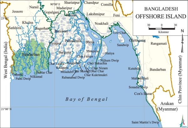
The major offshore islands are Hatiya, Bhola and Manpura. All these islands are densely populated. In the western region, the coastline is transverse to the structure of the continental margin. This front is stable and covered by the dense mangrove forest known as the [[Sundarbans, The|sundarbans]]. The very active tidal channel networks of this region have divided the region into several small islands, including the Sundarbans. The islands under the Sundarbans are treated as protected areas and cover the districts of Satkhira, Khulna and Bagerhat. Between Haringhata and Tentulia rivers there are quite a large number of densely populated offshore islands under the district of Barguna and Patuakhali. Some of these islands are Patharghata, Amtali, Kalapara, Rangabali and Bauphal. The coast of eastern region has a small number of islands. The most important of them are Sandwip, Urir Char, Kutubdia, Maheshkhali and [[St Martin's Island|st martin's island]]. Unlike Sandwip and Urir Char, Kutubdia, Maheshkhali and St Martin's islands are of tectonic origin. | The major offshore islands are Hatiya, Bhola and Manpura. All these islands are densely populated. In the western region, the coastline is transverse to the structure of the continental margin. This front is stable and covered by the dense mangrove forest known as the [[Sundarbans, The|sundarbans]]. The very active tidal channel networks of this region have divided the region into several small islands, including the Sundarbans. The islands under the Sundarbans are treated as protected areas and cover the districts of Satkhira, Khulna and Bagerhat. Between Haringhata and Tentulia rivers there are quite a large number of densely populated offshore islands under the district of Barguna and Patuakhali. Some of these islands are Patharghata, Amtali, Kalapara, Rangabali and Bauphal. The coast of eastern region has a small number of islands. The most important of them are Sandwip, Urir Char, Kutubdia, Maheshkhali and [[St Martin's Island|st martin's island]]. Unlike Sandwip and Urir Char, Kutubdia, Maheshkhali and St Martin's islands are of tectonic origin. | ||
Latest revision as of 02:38, 7 August 2021
Offshore Island An island (char) located near a coast or an offshore area. A large number of such islands have developed in-between the channels across the funnel-shaped and shallow northern bay of bengal. The combined Padma-Jamuna-Meghna river system through the meghna estuaries brings enormous load of sediment to the offshore territory, thereby forming a series of islands. The distribution pattern of the islands is such that a majority of them have developed in the central part of the coast, running east of Tentulia river to the feni river estuary. The region is most dynamic and intense erosion and sedimentation take place here regularly. As a result, the coastline is irregular and broken.

The major offshore islands are Hatiya, Bhola and Manpura. All these islands are densely populated. In the western region, the coastline is transverse to the structure of the continental margin. This front is stable and covered by the dense mangrove forest known as the sundarbans. The very active tidal channel networks of this region have divided the region into several small islands, including the Sundarbans. The islands under the Sundarbans are treated as protected areas and cover the districts of Satkhira, Khulna and Bagerhat. Between Haringhata and Tentulia rivers there are quite a large number of densely populated offshore islands under the district of Barguna and Patuakhali. Some of these islands are Patharghata, Amtali, Kalapara, Rangabali and Bauphal. The coast of eastern region has a small number of islands. The most important of them are Sandwip, Urir Char, Kutubdia, Maheshkhali and st martin's island. Unlike Sandwip and Urir Char, Kutubdia, Maheshkhali and St Martin's islands are of tectonic origin.
Some of the major offshore islands of Bangladesh are: Sonadia, Maheshkhali, Charmatarbari, Kutubdia, Sandwip, Urir Char, Hatiya, Nijumdwip, Manpura, Bhola, Charfasson, Dhalchar, Charkukrimukri, Char Mantaz, Char Lakshmi, Patuakhali, Rangabali, Moudubi, Kalapara, Patharghata, Char Laidia, Dublarchar, Nilkamal (Hiran Point), Putney Dwip, North Talpatti, south talpatti, St Martin's Island and Barguna. [Mohd Shamsul Alam]
