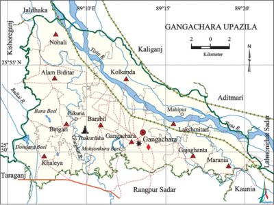
Gangachara Upazila
Gangachara Upazila (rangpur district) area 269.67 sq km, located in between 25°48' and 25°57' north latitudes and in between 89°05' and 89°21' east longitudes. It is bounded by kaliganj (lalmonirhat) and jaldhaka upazilas on the north, rangpur sadar and kaunia upazilas on the south, aditmari and lalmonirhat sadar upazilas on the east, kishoreganj (nilphamari) and taraganj upazilas on the west. The town is famous for tobacco business.
Population Total 297869; male 150300, female 147569; Muslim 263500, Hindu 34305, Christian 17 and others 47.
Water bodies Main rivers: tista and ghaghat; Bara Beel, Bullai Beel, Mohsonkura Beel and Dondara Beel are notable.
Administration Gangachara Thana, now an upazila, was formed in 1917.'
| Upazila | ||||||||
| Municipality | Union | Mouza | Village | Population | Density (per sq km) | Literacy rate (%) | ||
| Urban | Rural | Urban | Rural | |||||
| - | 10 | 93 | 128 | 12345 | 285524 | 1105 | 57.0 | 42.6 |
| Upazila Town | ||||||||
|
Area |
Mouza |
Population |
Density |
Literacy rate (%) | ||||
| 5.64 | 1 | 12345 | 2189 | 57.0 | ||||
| Union | ||||
| Name of union and GO code | Area (acre) | Population | Literacy rate (%) | |
| Male | Female | |||
| Alam Biditar 16 | 7175 | 17086 | 17019 | 38.5 |
| Kolkanda 63 | 8558 | 14182 | 13626 | 39.7 |
| Khaleya 52 | 5936 | 13198 | 13248 | 44.6 |
| Gangachara 31 | 6160 | 19881 | 19403 | 56.6 |
| Gajaghanta 42 | 4761 | 16527 | 16748 | 49.0 |
| Nohali 77 | 7667 | 12433 | 11803 | 37.1 |
| Barabil 19 | 8543 | 20016 | 20059 | 42.1 |
| Betgari 21 | 6029 | 12598 | 12039 | 38.0 |
| Marania 84 | 5106 | 13511 | 13201 | 31.9 |
| Lakshmitari 73 | 6703 | 10868 | 10423 | 47.5 |
Source Bangladesh Population Census 2011, Bangladesh Bureau of Statistics.
Archaeological heritage and relics Coleconda Mosque, Mandail Mosque at Barabil, Mosque at Mahipur Zamindar Bari, tomb of Sharif Pir Saheb at Pakuria, Hari Mandir at Chandanhat and Thakurdaha Mandir.

War of Liberation In the middle of August 1971, a Pakistani soldier entered Gangachara and chased a young girl and her father. The victims, finding no way to safety, jumped into the river and died. In the month of October, two Pakistani soldiers and five razakars were killed in an encounter with the guerrillas of Mujib Bahini. The Pak army later launched an attack on the innocent people and killed 17 pious Muslims inside the Taltala Mosque. 212 razakars of Gangachara police station surrendered on 13 December. A memorial monument was built at Mahipur.
For details: see গঙ্গাচড়া উপজেলা, বাংলাদেশ মুক্তিযুদ্ধ জ্ঞানকোষ (Encyclopedia of Bangladesh War of Liberation), বাংলাদেশ এশিয়াটিক সোসাইটি, ঢাকা ২০২০, খণ্ড ৯।
Religious institutions Mosque 305, temple 48.
Literacy rate and educational institutions Average literacy 43.2%; male 46.3%, female 40.0%. Educational institutions: college 8, secondary school 31, primary school 182, madrasa 23. Noted educational institutions: Gajaghanta High School and College (1906), Pakuria Sharif Bilateral High School (1919).
Cultural organisations Club 56, cinema hall 2, theatre group 2.
Main sources of income Agriculture 76.04%, non-agricultural labourer 4.78%, industry 0.28%, commerce 9.36%, transport and communication 2.17%, service 3.43%, construction 0.36%, religious service 0.14%, rent and remittance 0.15% and others 3.29%.
Ownership of agricultural land Landowner 58.44%, landless 41.56%; agricultural landowner: urban 55.75% and rural 58.59%.
Main crops Paddy, jute, tobacco, wheat, potato, ginger, maize, corn, brinjal, onion, patal, chilli, mushroom, vegetables.
Extinct or nearly extinct crops Sesame, linseed, kaun, sweet potato.
Main fruits Mango, black berry, jackfruit, banana, papaya.
Fisheries, dairies and poultries Fishery 27, dairy 10, poultry 120.'
Communication facilities Pucca road 110km, mud road 434 km.
Extinct or nearly extinct traditional transport Palanquin, bullock cart.
Noted manufactories Rice mill, saw mill, bidi factory, welding factory.
Cottage industries Goldsmith, blacksmith, potteries.
Hats, bazars and fairs Hats and bazars are 22, most noted of which are Gajaghanta, Mahipur, Gangachara, Maulvibazar, Betgari, Manthana, Bakshiganj, Khaprikhal, Chowdhury Hats and Pagla Pirer Bazar,' Pakuria Sharif Mela, Mahipur Maharram Mela, Dhamur Chaitra Sankranti Mela and Mongla Toba Chaitra Sankranti Mela.
Main exports Tobacco, potato, chilli, vegetables.
Access to electricity All the unions of the upazila are under rural electrification net-work. However 29.4% of the dwellings have access to electricity.
Sources of drinking water Tube-well 97.4%, tap 0.1% and others 2.5%.
Sanitation 41.7% of dwelling households of the upazila use sanitary latrines and 33.1% of dwelling households use non-sanitary latrines; 25.2% of households do not have latrine facilities.
Health centres Upazila health complex 1, family planning centre 10, satellite clinic 2, union health centre 2, permanent vaccination centre 240.
Natural disasters Gangachara area is highly prone to river erosions. In 1787, one fourth of the jamindari of Mahipur went under river bed due to the change of the course of the river Tista. As a result many people became landless. In 1964, the vast areas of' Marania, Gajaghanta and Mahipur unions went under river bed due to the erosion by the Tista. Besides, heavy damages to settlements and properties were caused due to the flood and river erosions of 1964, 1968, 1971 and 1974.
NGO activities thengamara mahila sabuj sangha, brac, asa, ESDO. [Md. Abdus Sattar]
References Bangladesh Population Census 2001 and 2011, Bangladesh Bureau of Statistics; Cultural survey report of Gangachara Upazila 2007.
