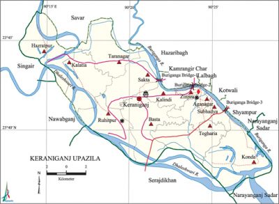
Keraniganj Upazila
Keraniganj Upazila (dhaka district) area 166.87 sq km, located in between 23°37' and 23°47' north latitudes and in between 90°13' and 90°29' east longitudes. It is bounded by savar and singair upazilas on the north, narayanganj sadar upazila on the south, hazaribagh, kamrangirchar, lalbagh, kotwali and shyampur thanas and Savar and Narayanganj sadar upazilas on the east, nawabganj, Singair and serajdikhan upazilas on the west. The upazila town is located on the south western side of Dhaka City and on the other side of the buriganga.
Population Total 794360; male 421809, female 372551; Muslim 737485, Hindu 56757, Buddhist 11, Christian 94 and others 13.
Water bodies Main rivers: Buriganga, dhaleshwari, ichamati.
Administration Keraniganj Thana was formed in 1817 and it was turned into an upazila in 1983.
| Upazila | ||||||||
| Municipality | Union | Mouza | Village | Population | Density (per sq km) | Literacy rate (%) | ||
| Urban | Rural | Urban | Rural | |||||
| - | 12 | 121 | 423 | 1196 | 793164 | 4760 | 51.8 (2001) | 58.5 |
| Upazila Town | ||||||||
|
Area (sq km) |
Mouza |
Population |
Density (per sq km) |
Literacy rate (%) | ||||
| 0.58 | - | 1196 | 2063 | 51.8 (2001) | ||||
| Union | ||||
| Name of union and GO code | Area (acre) | Population | Literacy rate (%) | |
| Male | Female | |||
| Aganagar 11 | 369 | 44927 | 28085 | 63.8 |
| Kalatia 25 | 4297 | 19261 | 20746 | 60.8 |
| Kalindi 34 | 1677 | 24467 | 22316 | 63.3 |
| Konda 43 | 6270 | 34821 | 32383 | 53.6 |
| Zinjira 94 | 433 | 58635 | 51347 | 61.1 |
| Taranagar 77 | 4295 | 21441 | 20762 | 58.6 |
| Tegharia 86 | 4330 | 16766 | 15650 | 53.9 |
| Basta 13 | 4915 | 16886 | 17295 | 57.3 |
| Ruhitpur 51 | 3730 | 15645 | 15918 | 54.8 |
| Subhadya 69 | 2563 | 122612 | 103253 | 58.3 |
| Sakta 60 | 4051 | 30028 | 28047 | 60.9 |
| Hazratpur 17 | 4161 | 16320 | 16749 | 45.7 |
Source Bangladesh Population Census 2001 and 2011, Bangladesh Bureau of Statistics.
Archaeological heritage and relics Jinjira Palace (Mughal Subadar Ibrahim Khan II built this palace as his recreation resort. After the fall of Sirajuddwla, Ghaseti Begum, Amina Begum, wife of Sirajuddowla and his daughter were kept confined in this palace), house of Zamindar Prashanta Karmakar (Upazila Office Building).

War of Liberation During the war of liberation, the Pak army set most of the houses of Konakhola, Basta, Brahmankritta, Goalkhali, Oalitia and Khagail Kholamora villages on fire. The Pak army was driven away by counterattacks of the freedom fighters, including a notable encounter at Sonakanda of the upazila.
For details: see কেরানীগঞ্জ উপজেলা, বাংলাদেশ মুক্তিযুদ্ধ জ্ঞানকোষ (Encyclopedia of Bangladesh War of Liberation), বাংলাদেশ এশিয়াটিক সোসাইটি, ঢাকা ২০২০, খণ্ড ২।
Religious institutions Mosque 585, temple 96, tomb 1.
Literacy rate and educational institutions Average literacy 58.5%; male 60.8%, female 56.0%. Educational institutions: college 8, technical college 1, secondary school 38, primary school 112, madrasa 14.
Cultural organisations Club 60, community centre 25,' cinema hall 5, auditorium 2.
Main sources of income Agriculture 11.31%, non-agricultural labourer 3.73%, industry 3.62%, commerce 29.14%, transport and communication 7.37%, service 16.94%, construction 3.66%, religious service 0.19%, rent and remittance 4.65% and others 19.39%.
Ownership of agricultural land Landowner 35.46%, landless 64.54%.
Main crops Jute, wheat, potato, onion, oil seed.
Extinct or nearly extinct crops Aus paddy, khesari, motar pulses.
Main fruits Mango, Jackfruit, banana, papaya, coconut.
Fisheries, dairies and poultries Dairy 424, poultry 179.
Communication facilities Pucca road 254 km, semi-pucca road 91 km, mud road 778 km; waterway 120 km. Culvert 3, bridge 228.
Extinct or nearly extinct traditional transport Palanquin, horse carriage, bullock cart.
Noted manufactories Textile industries, cold-storage, jute mill, brick-field.
Cottage industries Goldsmith, blacksmith, potteries, embroidery, wood work.
Hats, bazars and fairs Hats and bazars are 18, fairs 2, most noted of which are Kalatia Bazar, Ati Bazar, Ruhitpur Bazar, Jinjira Bazar, Kaliganj Bazars, Jindapir Mazar Mela and Adu Pagla Mela.
Main exports Jute, oil seed.
Access to electricity All the unions of the upazila are under rural electrification net-work. However 96.9% of the dwelling households have access to electricity.
Sources of drinking water Tube-well 66.1%, tap 31.2% and others 2.7%.
Sanitation 92.2% of dwelling households of the upazila use sanitary latrines and 7.2% of dwelling households use non-sanitary latrines; 0.6% of households do not have latrine facilities.
Health centres Upazila health complex 1, Union health and family welfare centre 15, family planning centre 5,' satellite clinic 3, health centre 1.
NGO activities Operationally important NGOs are asa, brac, proshika, Protasa, thengamara mahila sabuj sangha. [Md Abu Hasan Farooque]
References' Bangladesh Population Census 2001 and 2011, Bangladesh Bureau of Statistics; Field report of Keraniganj Upazila 2010.
