Muktagachha Upazila
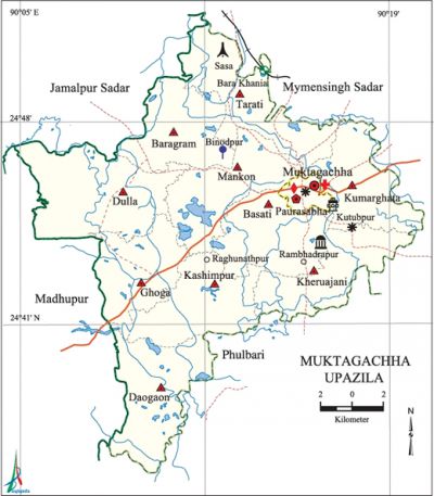
Muktagachha Upazila (mymensingh district) area 314.70 sq km, located in between 24°36' and 24°52' north latitudes and in between 90°04' and 90°20' east longitudes. It is bounded by mymensingh sadar and jamalpur sadar upazilas on the north, fulbaria upazila on the south, Mymensingh Sadar and Fulbaria upazilas on the east, madhupur and Jamalpur Sadar upazilas on the west.
Population Total 415473; male 206647, female 208826; Muslim 395926, Hindu 18766, Buddhist 4, Christian 713 and others 64. Indigenous community such as garo belongs to this upazila.
Administration Muktagachha Thana was formed in 1961 and it was turned into an upazila in 1983. Muktagachha Municipality was formed in 1875.
| Upazila | ||||||||
| Municipality | Union | Mouza | Village | Population | Density (per sq km) | Literacy rate (%) | ||
| Urban | Rural | Urban | Rural | |||||
| 1 | 10 | 252 | 282 | 49915 | 365558 | 1320 | 60.2 | 41.2 |
| Municipality | ||||||||
|
Area (sq km) |
Ward |
Mahalla |
Population |
Density (per sq km) |
Literacy rate (%) | |||
| 12.57 | 9 | 21 | 49915 | 3971 | 60.2 | |||
| Union | ||||
| Name of union and GO code | Area (acre) | Population | Literacy rate (%) | |
| Male | Female | |||
| Kashimpur 51 | 7413 | 19267 | 19083 | 41.06 |
| Kumarghata 69 | 5947 | 17489 | 17414 | 46.7 |
| Kheruajani 60 | 7103 | 17479 | 18898 | 37.2 |
| Ghoga 43 | 7003 | 13969 | 14151 | 36.9 |
| Tarati 94 | 7860 | 21080 | 20434 | 43.8 |
| Daogaon 25 | 7579 | 19032 | 19798 | 30.7 |
| Dulla 34 | 10328 | 17847 | 18207 | 39.2 |
| Baragram 16 | 7290 | 16989 | 17012 | 44.4 |
| Basati 17 | 6620 | 18929 | 19169 | 47.5 |
| Mankon 77 | 7460 | 19439 | 19872 | 42.5 |
Source Bangladesh Population Census 2011, Bangladesh Bureau of Statistics.

Archaeological heritage and relics Bhuiyanbari' Mosque, Gopal and Shiva Mandir at the Atani Zamindar Bari (built in the last part of 18th century), Anandamoyee Kali and Shiva Mandir, Lakshmikhola Shiva Mandir, tomb of Kutub Shah at Kutubpur, tomb of Joyen Shah at Rasulpur, tomb of Kali Shah Dewan.
War of Liberation The freedom fighters resisted the Pak army at Jalchhatra on their way to Muktagachha on 23 April 1971. The freedom fighters, under Commander Refazuddin, launched attacks on the Pak army at Bat-tali, Bhiti-bari and Muktagachha Police Station. The Pak army conducted brutal mass killing, torture and plundering at villages Binodbari, Mankon, Bouerchar Shasha, etc. of the upazila. Muktagachha upazila was liberated on 10 December. There are mass killing sites at 4 places (premises of Zamindar Bakul Babu of the upazila sadar, Moylakhana (dumping area), Mankon and Binodbari) and mass grave at 5 places (Moylakhana of the upazila sadar, Mazipara of Ishwar Gram, Sreepur in Mankon Union, Mazihati, Shasha of Tarati Union) of the upazila; 2 memorial monuments (one at Mazihati and the other at Bangbangla adjacent Baizana Bridge) had been built.
For details: see মুক্তাগাছা উপজেলা, বাংলাদেশ মুক্তিযুদ্ধ জ্ঞানকোষ (Encyclopedia of Bangladesh War of Liberation), বাংলাদেশ এশিয়াটিক সোসাইটি, ঢাকা ২০২০, খণ্ড ৭।
Religious institutions Mosque 521, temple 22, church 5, tomb 5.
Literacy rate and educational institutions Average literacy 43.5%; male 45.0%, female 42.0%. Educational institutions: college 10, secondary school 42, primary school 144, regional scout training centre 1, regional cooperative institute 1, madrasa 52. Noted educational institutions: Ramkishore High School (1300), Nagendra Narayan Primary School (1907), Kheruajani High School (1899), MN Pilot Girls' High School (1907).
Newspapers and periodicals Weekly: Aloran Barta; fortnightly: Sabar Katha; periodical: Sonali Sis; defunct: Promodi, Surid, Nirmallah, Desher Khabar, Muktakantha, Ajker Muktagachha.
Cultural organisations Library 1, cinema hall 6.
Main sources of income Agriculture 59.26%, non-agricultural labourer 4.61%, industry 1.13%, commerce 11.29%, transport and communication 6.32%, service 4.96%, construction 1.35%, religious service 0.22%,' rent and remittance 0.28% and' others 10.58%.
Ownership of agricultural land Landowner 55.46%, landless 44.54%; agricultural landowner: urban 57.09% and rural 40.40%.
Main crops Paddy, jute, betel leaf, wheat, sugarcane, mustard.
Extinct or nearly extinct crops Local varieties of banana, pulse.
Main fruits Banana, blackberry, watermelon, mango, jackfruit, coconut.
Fisheries, dairies and poultries Fishery 103, dairy 27, poultry 61.
Communication facilities Pucca road 219 km, semi-pucca road 2 km, mud road 910 km.
Extinct or nearly extinct traditional transport Palanquin, horse carriage, buffalo cart.
Noted manufactories Oil mill 12, saw mill 16, rice mill 221, biscuit factory 15, bidi factory 2, printing press 3, food godown.
Cottage industries Blacksmith 72, weaving 126, milk products 25 wood work 40, bamboo work 20, cane work 10.
Hats, bazars and fairs Hats and bazars are 18, fairs 5, most noted of which are Dorichari Ani Bazar, Raghunathpur (Rouarchar) Hat, Chechua Hat, Gabtali Hat, Dropour Hat, Kutubpur Shivaratri Mela, Ramchandrapur Mela, Lakshmikhola Mela, Sapanna Prahar Mela.
Main exports Rice, jute, betel leaf, bidi.
Access to electricity All the wards and unions of the upazila are under rural electrification net-work. However 45.4% of the dwelling households have access to electricity.
Sources of drinking water Tube-well 92.4%, tap 1.9% and others 5.7%.
Sanitation 46.1% of dwelling households of the upazila use sanitary latrines and 45.6% of dwelling households use non-sanitary latrines; 8.3% of households do not have latrine facilities.
Health centres Upazila health complex 1, satellite clinic 4, hospital 1,' community clinic 27, family planning centre 6, veterinary hospital 1.
NGO activities Operationally important NGOs are brac, caritas, proshika, asa, Pratasha. [Mesbah Uddin Tuhin]
References Bangladesh Population Census 2001 and 2011, Bangladesh Bureau of Statistics; Cultural survey report of Muktagachha Upazila 2007.
