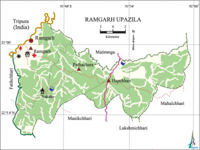
Ramgarh Upazila
Ramgarh Upazila (khagrachhari district) area 287.89 sq km, located in between 22°49' and 23°02' north latitudes and in between 91°44' and 91°59' east longitudes. It is bounded by tripura state of India and matiranga upazila on the north, manikchhari and lakshmichhari upazilas on the south, mahalchhari upazila on the east and fatikchhari upazila on the west.
Population Total 71677; male 36644, female 35033; Muslim 41316, Hindu 11317, Buddhist 18630, Christian 164 and others 250. Indigenous communities such as tripura, marma and chakma belong to this upazila.
Administration Ramgarh Thana was formed in 1905 and it was turned into an upazila in 1983.
| Upazila | ||||||||
| Municipality | Union | Mouza | Village | Population | Density (per sq km) | Literacy rate (%) | ||
| Urban | Rural | Urban | Rural | |||||
| 1 | 3 | 12 | 136 | 37033 | 34644 | 249 | 55.8 (2001) | 36.5 |
| Municipality | ||||||||
| Area (sq km) |
Ward | Mahalla | Population | Density (per sq km) |
Literacy rate (%) | |||
| - | 9 | 29 | 24854 | - | 59.6 | |||
| Upazila Town | ||||||||
|
Area (sq km) |
Mouza |
Population |
Density (per sq km) |
Literacy rate (%) | ||||
| 64.75 (2001) | 2 | 12179 | 447 (2001) | 36.8 | ||||
| Union | ||||
| Name of union and GO code | Area (acre) | Population | Literacy rate (%) | |
| Male | Female | |||
| Pathachhara 57 | 20480 | 6457 | 6472 | 33.0 |
| Ramgarh 76 | 17280 | 6507 | 6454 | 36.0 |
| Hapchhari38 | 21760 | 10815 | 10118 | 39.1 |
Source Bangladesh Population Census 2001 and 2011, Bangladesh Bureau of Statistics.

Archaeological heritage and relics Mahamuni Buddhist Monastery (Nakaba), SDO Bungalow.
Historical events The border security forces of Bangladesh now named as the Bangladesh Border Guard was first formed as Ramgarh Local Battalion on 21 June 1795.
War of Liberation The first training camp of the freedom fighters including young people, students and local persons engaged in various professions of the upazila was established at Ramgarh on 8 April 1971. The freedom fighters had an encounter with the Pak army at Mahamuni Para in August 1971 in which 17 Pak soldiers were killed. On 22 December 1986 the shanti bahini launched a surprise attack and killed 22 innocent persons. A memorial monument ('Sarthak a Janmo') has been built in the upazila.
For details: see রামগড় উপজেলা, বাংলাদেশ মুক্তিযুদ্ধ জ্ঞানকোষ (Encyclopedia of Bangladesh War of Liberation), বাংলাদেশ এশিয়াটিক সোসাইটি, ঢাকা ২০২০, খণ্ড ৯।
Religious institutions Mosque 74, temple 11, buddhist vihara and keyang 32, church 2, sacred place 1, ashrama 3. Noted religious institutions: Ramgarh Central Jami Mosque, Mahamuni Buddhist Monastery, Ramgarh Dakshineswari Kalibari.
Literacy rate and educational institutions Average literacy 44.9%; male 49.9%, female 39.8%. Educational institutions: college 2, secondary school 12, primary school 60, community school 5, kindergarten 6, satellite school 5, madrasa 7, orphanage 1. Noted educational institutions: Ramgarh Government Degree College (1980), Ramgarh Government High School (1952), Ramgarh Girls' High School (1964), Chowdhury Para Junior High School (1988), Shaheed Captain Kader Bidya Niketon (1994), Ramgarh Government Model Primary School (1937), Ramgarh Government Girls' Primary School (1964), Ramgarh Ganiatul Ulum Senior Madrasa.
Newspapers and periodicals Weekly: Binnaz.
Cultural organisations Library 2, club 5, press club 1, cinema hall 2, auditorium 2, stadium 1, playground 7.
Tourists spots Ramgarh Lake and Hanging Bridge, Soil Conservation and Research Centre, Rifles Monument, Ramgarh Horticulture Centre.
Main sources of income Agriculture 47.61%, non-agricultural labourer 11.04%, commerce 12.80%, transport and communication 2.62%, service 7.65%, construction 2.39%, religious service 0.26%, rent and remittance 1.11% and others 14.52%.
Ownership of agricultural land Landowner 37.76%, landless 62.24%; agricultural landowner: urban 29.55% and rural 45.96%.'
Main crops Paddy, sweet potato, ginger, turmeric, sugarcane, bamboo, vegetables.
Extinct or nearly extinct crops Local verities of paddy, Sesame, kaun, mustard.
Main fruits Mango, jackfruit, litchi, banana, pine apple, lemon, shaddock.
Fisheries, dairies and poultries Fishery 9, dairy 5, poultry 20, hatchery (fish) 1.
Communication facilities Pucca road 53 km, semi-pucca road 68 km, mud road 257 km.
Extinct or nearly extinct traditional transport Bullock cart, buffalo cart.
Noted manufactories Rice mill, saw mill, wine factory, plywood factory, ice factory.
Cottage industries Goldsmith, blacksmith, weaving, tailoring, wood work.
Hats, bazars and fairs Hats and bazars are 9, fairs 6, most noted of which are Ramgarh Bazar, Sonaipool Bazar, Nakaba Bazar, Chainda Mela and Mahamuni Mela.
Main exports Jackfruit, lemon, sweet potato, banana, paddy, wood, bamboo.
Access to electricity All the unions of the upazila are under rural electrification net-work. However 28.8% of the dwelling households have access to electricity.
Natural resources Natural Gas (Semutang Gas Field), wood, bamboo.
Sources of drinking water Tube-well 69.8%, tap 0.7% and others 29.5%. Sanitation 46.3% of dwelling households of the upazila use sanitary latrines and 41.3% of dwelling households use non-sanitary latrines; 12.4% of households do not have latrine facilities.
Health centres Hospital 2, health and family welfare centre 3, Islamic mission health centre 1, clinic 1, diagnostic centre 3, veterinary 1.
Natural disasters About 20 persons were victims of the flash flood on 26 June 2003. Besides, it also caused heavy damages to settlements, roads and plants of the upazila.
NGO activities Operationally important NGOs are brac, IDF, proshika, asa. [Md. Nizam Uddin Lavlu]
References Bangladesh Population Census 2001 and 2011 and 2011, Bangladesh Bureau of Statistics; Cultural survey report of Ramgarh Upazila 2007.
