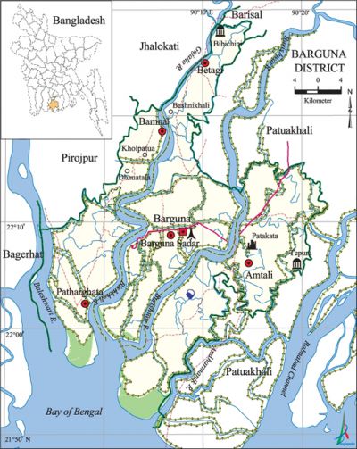
Barguna District
Barguna District (barisal division) area 1831.31 sq km, located in between 21°48' and 22°29' north latitudes and in between 89°52' and 90°22' east longitudes. It is bounded by jhalokati, barisal, pirojpur and patuakhali districts on the north, Patuakhali district and bay of bengal on the south, Patuakhali district on the east, Pirojpur and bagerhat districts on the west.
Population Total 848554; male 430422, female 418232; Muslim 777370, Hindu 69446, Buddhist 302, Christian 1304 and others 132.
Water bodies bishkhali, Baleshwari, Burishwar, Payra, Andharmanik and Gajalia rivers are notable.
Administration Barguna Thana was established in the last part of the eighteenth century and it was upgraded into a Sub Division in 1969; it was turned into a district in 1984.
| District | |||||||||
| Area (sq km) | Upazila | Municipality | Union | Mouza | Village | Population | Density (per sq km) | Literacy rate (%) | |
| Urban | Rural | ||||||||
| 1831 | 5 | 4 | 38 | 257 | 560 | 87582 | 760972 | 463 | 55.3 |
| Others Information of District | ||||||||
| Name of upazila | Area (sq km) | Municipality | Union | Mouza | Village | Population | Density (per sq km) | Literacy rate (%) |
| Amtali | 720.76 | 1 | 10 | 66 | 181 | 259757 | 360 | 45.9 |
| Patharghata | 387.36 | 1 | 7 | 42 | 66 | 162025 | 418 | 63.2 |
| Barguna Sadar | 454.39 | 1 | 10 | 51 | 191 | 237613 | 523 | 55.2 |
| Bamna | 101.05 | - | 4 | 39 | 49 | 69803 | 691 | 64.2 |
| Betagi | 167.75 | 1 | 7 | 59 | 73 | 119356 | 711 | 59.7 |
Source Bangladesh Population Census 2001,Bangladesh Bureau of Statistics.

War of Liberation During the war of liberation, the Pak army killed more than one hundred prisoners of the Barguna district Jail and buried them in a mass grave on the west side of the Jail compound on 29 and 30 November 1971. Besides, the Pak army killed many people of the Barguna Town area; they also killed a number of freedom fighters while on retreat. Heavy damages to properties were caused when the Pak army set the eastern extremity of Betagi Bazar of Betagi upazila on fire. A number of Pak soldiers and rajakars were killed in a frontal encounter between the freedom fighters and the Pak army at Badnikhali Bazar of Bura Mazumdar union; besides, the motor launch MV Munir carrying the Pak army, was seriously damaged.
Marks of War of Liberation Mass grave 2, (at a place adjacent to the District Jail, adjacent to the Patharghata Launch Ghat); foundation pillar of Sector 9 of the War of Liberation (Bamna), memorial pillar 3 (Amtali).
Literacy rate and educational institutions Average literacy 55.3%; male 57.7%, female 52.8%. Educational institutions: law college 1, college 25, MED college 1, non-government BED college 3, non-government vocational school 4, technical school and college 1, government PTI 1, government youth development centre 1, secondary school 162, primary school 727, madrasa 132.
Main sources of income Agriculture 62.67%, non-agricultural labourer 4.48%, industry 0.7%, commerce 13.38%, transport and communication 2.03%, service 6.72%, construction 1.46%, religious service 0.21%, rent and remittance 0.22% and others 8.13%.
Newspapers and periodicals Daily: Dainik Dipanchal, Dainik Saikat Sangbad, fortnightly: Barguna; weekly: Barguna Kantha, Barguna Barta, Bhatiali, Payra Par, Weekly Barguna, Betagir Katha; defunct: Dainik Ajker Kantha; Bargunar Kantha.
Folkculture Jarigan, Sarigan, kavigan, kirtan, hoila, folktale and folk drama are notable.
Tourist spots Bibichini Shahi Mosque (betagi), Buddhist temple (Taltali) and Buddhist Academy. [Md Monir Hossain Kamal]
See also The upazilas under this district.
References Bangladesh Population Census 2001, Bangladesh Bureau of Statistics; Cultural survey report of Barguna District 2007; Cultural survey report of different Upazilas of Barguna District 2007.
