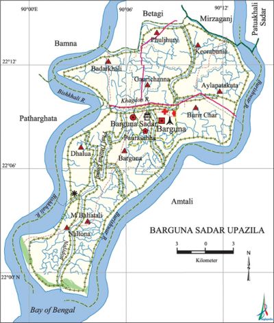
Barguna Sadar Upazila
Barguna Sadar Upazila (barguna district) area 454.39 sq km, located in between 21°58' and 22°15' north latitudes and in between 89°59' and 90°14' east longitudes. It is bounded by betagi, mirzaganj and patuakhali sadar upazila upazilas on the north, bay of bengal and amtali upazila on the south, Amtali upazila on the east, patharghata and bamna upazilas on the west.
Population Total 237613; male 120830, female 116783; Muslim 220057, Hindu 17376, Buddhist 26, Christian 137 and others 17.
Water bodies burishwar, bishkhali , Khagdon and Nalidon rivers and Patkata, Barguna, Junia, Lalbongola and Phuldhalua canals are notable.
Administration Barguna Thana was formed in 1904 and it was turned into an upazila in 1984. '
| Upazila | ||||||||
| Municipality | Union | Mouza | Village | Population | Density (per sq km) | Literacy rate (%) | ||
| Urban | Rural | Urban | Rural | |||||
|
1 |
10 |
51 |
191 |
26954 |
210659 |
523 |
71.9 |
52.9 |
| Municipality | ||||||||
|
Area |
Ward |
Mahalla |
Population |
Density |
Literacy rate | |||
|
15.58 |
9 |
18 |
26954 |
1730 |
71.9 | |||
| Union | ||||
| Name of union and GO code | Area (acre) | Population | Literacy rate (%) | |
| Male | Female | |||
|
Aylapatakata 17 |
7086 |
9497 |
9309 |
47.06 |
|
M Baliatali 85 |
15495 |
13289 |
13237 |
50.00 |
|
Keorabunia 76 |
5855 |
8418 |
8394 |
50.80 |
|
Gaurichanna 66 |
6611 |
11438 |
11172 |
62.36 |
|
Dhalua 47 |
7421 |
11698 |
11985 |
51.24 |
|
Naltona 95 |
8435 |
9211 |
8969 |
47.64 |
|
Phuljhury 57 |
5244 |
6768 |
7000 |
60.07 |
|
Badarkhali 19 |
7616 |
13278 |
12562 |
53.86 |
|
Barguna 28 |
5594 |
9389 |
9355 |
55.06 |
|
Burir Char 38 |
8661 |
13093 |
12597 |
52.33 |
Source Bangladesh Population Census 2001, Bangladesh Bureau of Statistics.

History of the War of Liberation On 29 and 30 November 1971 the Pak army killed more than one hundred prisoners of the Barguna Jail and buried them in a mass grave on the west side of the Jail compound. During the war of liberation the Pak army killed many people of the Barguna town area; they also killed a number of freedom fighters while on retreat. Barguna was liberated on 3 December.
Marks of War of Liberation Mass grave 1 (near the district Jail).
Religious institutions Mosque 610, temple 6.
Literacy rate and educational institutions Average literacy 55.2%; male 57.6%, female 52.7%. Educational institutions: college 7, MED college 1, BED college 1, PTI 1, vocational school 4, technical school and college 1, youth development centre 1, secondary school 52, primary school 233, madrasa 51. Most noted educational institution: Chhota Gaurichanna Secondary School (1926).
Newspapers and periodicals Daily: Dainik Dipanchal, Dainik Saikat; fortnightly: Barguna; Weekly: Barguna, Bargunar Kantha; Defunct: Dainik Ajker Kantha, Bargunar Kantha.
Cultural organisations Library 2, cinema hall 2.Main sources of income Agriculture 55.82%, non-agricultural labourer 6.21%, industry 0.6%, commerce 15.62%, transport and communication 2.61%, service 8.06%, construction 1.93%, religious service 0.27%, rent and remittance 0.29% and others 8.59%.
Main crops Paddy, ground-nut, khesari, mug, vegetables.
Extinct or nearly extinct crops Sweet potato, tobacco, futi, water-melon, sesame, mustard.
Main fruits Jackfruit, banana, papaya, palm, pineapple.
Fisheries, dairies and poultries Fishery 16, dairy 5, poultry 26, hatchery 4.
Communication facilities Roads: mud road 180 km; waterway 38 nautical miles.
Extinct or nearly extinct traditional transport Palanquin.
Noted manufactories Rice mill, oil mill, saw mill, ice factory, bidi factory, welding factory.
Cottage industries Goldsmith, blacksmith, embroidery, weaving, wood work.
Hats, bazars and fairs Barguna Baishakhi Mela; Gaurichanna, Babuganj and Chandkhali bazars are notable.
Main exports Palm molasses, hilsa fish, dry shrimp.
Access to electricity All the wards and unions of the upazila are under rural electrification net-work. However 15.24% of the dwelling households have access to electricity.
Sources of drinking water Tube-well 92.68%, tap 1.27%, pond 5.82% and others 0.24%.
Sanitation 44.15% (rural 38.69% and urban 90.8%) of dwelling households of the upazila use sanitary latrines and 50.97% (rural 56.32% and urban 5.18%) of dwelling households use non-sanitary latrines; 4.89% of households do not have latrine facilities.
Health centres Hospital 1, upazila health centre 1, health and family welfare centre 10, clinic 1, satellite clinic 1, maternity and child clinic 1, community clinic 27.'
NGO activities Operationally important NGOs are brac, CARE, asa. [Safi Uddin Ahmed]
References Bangladesh Population Census 2001, Bangladesh Bureau of Statistics; Cultural survey report of Barguna Sadar Upazila 2007.
