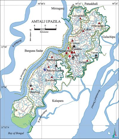
Amtali Upazila
Amtali Upazila (barguna district) area 398.88 sq km, located in between 21°51' and 22°18' north latitudes and in between 90°00' and 90°23' east longitudes. It is bounded by patuakhali sadar upazila on the north, bay of bengal on the south, galachipa and kalapara upazilas on the east, barguna sadar and mirzaganj upazilas (patuakhali) on the west.
Population Total 182798; male 88461, female 94337; Muslim 172367, Hindu 10409, Christian 11, Buddhist 10 and others 12. Indigenous community such as rakhain community belongs to Barabagi and Panchakoralia unions to this upazila.
Water bodies Burishwar and Andarmanick rivers and Rabnabad channel are noted.
Administration Gulisakhali thana, formed in 1859, was shifted to Amtali in 1904 and it was turned into an upazila in 1982.
| Upazila | ||||||||
| Municipality | Union | Mouza | Village | Population | Density (per sq km) | Literacy rate (%) | ||
| Urban | Rural | Urban | Rural | |||||
| 1 | 7 | 47 | 114 | 21808 | 160990 | 458 | 64.3 (2001) | 51.8 |
| Municipality | |||||
|
Area |
Ward |
Mahalla |
Population |
Density |
Literacy |
| 8.75 (2001) | 9 | 14 | 17311 | 1521 (2001) | 68.7 |
| Upazila Town | ||||
|
Area |
Mouza |
Population |
Density |
Literacy |
| 12.25 (2001) | 1 | 4497 | 400 (2001) | 47.0 |
| Union | ||||
| Name of union and GO code | Area (acre) | Population | Literacy rate (%) | |
| Male | Female | |||
| Atharogashia 23 | 11269 | 11350 | 12094 | 44.2 |
| Arpangashia 15 | 8624 | 7224 | 7649 | 54.8 |
| Amtali 13 | 15914 | 11838 | 12317 | 50.6 |
| Kukua 87 | 11288 | 11360 | 12668 | 49.0 |
| Gulishakhali 63 | 13887 | 13624 | 14834 | 53.4 |
| Chowra 47 | 10239 | 10154 | 10648 | 46.6 |
| Haldia 71 | 22154 | 14210 | 15517 | 51.0 |
Source Bangladesh Population Census 2001 and 2011, Bangladesh Bureau of Statistics.
Archaeological heritage and relics Tomb of Kazi Kalu at Tepura and clay fort at Chaora Patakata (Mughal period).
War of Liberation Almost all areas of Amtali upazila were under the control of freedom fighters during the entire period of the War of Liberation and the only major operation that the freedom fighters had carried out in the upazila was for taking control over the Amtali Police Station. Memorial plaques have been established at 3 places of the upazila.
For details: see আমতলী উপজেলা, বাংলাদেশ মুক্তিযুদ্ধ জ্ঞানকোষ (Encyclopedia of Bangladesh War of Liberation), বাংলাদেশ এশিয়াটিক সোসাইটি, ঢাকা ২০২০, খণ্ড ১।
Literacy rate and educational institutions Average literacy 52.8%; male 54.9%, female 49.9%. Noted educational institutions: Amtali Degree College (1969), Amtali AK Pilot High School (1934).
Newspaper and periodicals Payrapar (weekly), Shok Noy Shakti.

Cultural organizations Club 26, Library 1, theatre group 2, literary organisation 2, women's organisation 2, cinema hall 3.
Main sources of income Agriculture 70.46%, non-agriculture labourer 4.01%, commerce 9.42%, service 4.27%, construction 1.02%, religious service 0.18%, rent and remittance 0.16%, transport and communication 1.74%, industry 0.26% and others 8.48%.
Main crops Paddy, peanut, khesari, mug, gram, mustard, potato, chilli, pumpkin.
Extinct or nearly extinct crops Sesame, linseed.
Main fruits Guava, amra, watermelon.
Communication facilities Pucca road 128 km, semi-pucca road 25 km, mud road 1618 km; waterway 140 km.
Traditional transport Palanquin.
Noted manufactories Saw mill, flour mill, soap factory, pen factory.
Cottage industries Weaving, blacksmith, welding, potteries, wood work, cane work, bamboo work.
Hats, bazars and fair Gazipur cattle market and Gazi Kalu's Mela are notable.
Access to electricity All the wards and unions of this upazila are under electricity net-work. However 21.6% of the dwelling households only have access to electricity.
Sources of drinking water Tube-well 96.9%, tap 1.2% and others 1.9%. Arsenic in tolerable limit has been detected in shallow tube-well water of this upazila.
Sanitation 66.9% of dwelling households of the upazila use sanitary latrines and 28.7% of dwelling houses use non-sanitary latrines; 4.4% of households do not have sanitation facilities.
Heath centres Upazila health centre 1, satellite clinic 3, union health and family planning centre 3, family planning centre 7.
Natural disasters A devastating tidal bore and cyclone of 12 November 1970 in the region causing loss of the people and of livestock; it also damaged serious damage to crops.
NGO activities Care, brac, asa, proshika, Dhaka Ahsania Mission, caritas. [Shabuddin Panna]
References Bangladesh Population Census 2001 and 2011, Bangladesh Bureau of Statistics; Cultural survey report of Amtali Upazila 2007.
