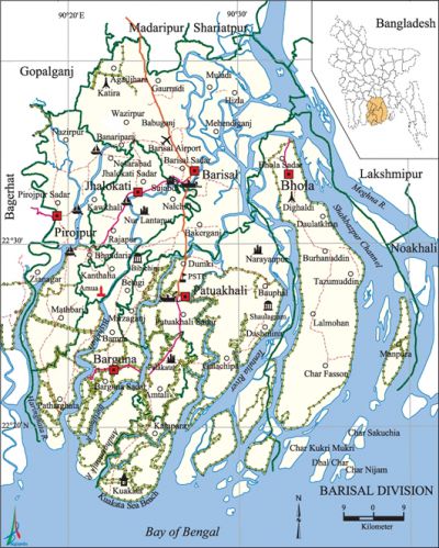
Barisal Division
Barisal Division area 13295.55 sq km, located in between 21°48' and 22°29' north latitudes and in between 89°52' and 90°22' east longitudes. It is bounded by gopalganj, madaripur and shariatpur districts on the north, bay of bengal on the south, lakshmipur and noakhali districts on the east, bagerhat district on the west.
Population Total 8173818; male 4159210, female 4014608; Muslim 7338089, Hindu 816051, Buddhist 14348, Christian 3492 and others 1738.
Water bodies Bay of Bengal; main rivers: tentulia, kirtankhola, bishkhali, Kaliganga, Haringhata, burishwar, Agunmukha, Galachipa, Baleshwari, Jainty, Amtali, meghna and Shahbazpur Channel.
Administration Barisal division was formed on 1 January 1993; Barisal municipality was established in 1957. Barisal City Corporation was formed comprising 30 Wards in 2000.
| Division | ||||||||||
| Area (sq km) |
City corporation | District | Upazila | Paurasabha | Union | Ward | Population | Density (per sq km) |
Literacy rate (%) | |
| Urban | Rural | |||||||||
|
13644.85 |
1 |
6 |
39 |
22 |
333 |
219 |
7010943 |
1162775 |
3983 |
55.09 |
| Zila | |||||||||||
|
Name of Zila |
Area |
Upazila |
Municipality |
Ward |
Mohalla |
Union |
Mouza |
Village |
Population |
Density |
Literacy rate (%) |
|
Patuakhali |
3220.15 |
7 |
3 |
27 |
62 |
67 |
571 |
865 |
1460781 |
454 |
51.65 |
|
Pirojpur |
1307.61 |
6 |
3 |
27 |
55 |
51 |
399 |
645 |
1111068 |
850 |
64.30 |
|
Jhalokati |
758.06 |
4 |
2 |
18 |
68 |
31 |
400 |
452 |
694231 |
916 |
65.40 |
|
Barguna |
1831.31 |
5 |
4 |
36 |
51 |
38 |
257 |
560 |
848554 |
463 |
55.30 |
|
Barisal |
2790.51 |
10 |
5 |
66 |
120 |
86 |
1147 |
1290 |
2355967 |
844 |
57.0 |
|
Bhola |
3737.21 |
7 |
5 |
45 |
63 |
62 |
409 |
461 |
1703117 |
456 |
36.89 |
Source Bangladesh Population Census 2001, Bangladesh Bureau of Statistics.

Religious institutions Mosque 16979, temple 2769, church 56, tomb 33, pagoda 22, math 5.
Literacy rate and educational institutions Average literacy 55.09%; male 56.47%, female 55.63%. Educational institutions: university 1, medical college 1, law college 3, teachers training college 4, college 80, polytechnic institute 3, nursing institute 1, secondary school 1051, primary school 4565, madrasa 1716. Noted educational institutions: Patuakhali Science and Technology University (2001), Sher-e-Bangla Medical College (1969), Barisal Polytechnic Institute (1962), Barisal Nursing Institute, BM College (1884), Barisal Cadet College (1981).
Main sources of income Agriculture 54.72%, non-agircultural labourer 4.97%, industry 0.74%, commerce 15.42%, transport and communication 2.35%, service 6.66%, construction 4.85%, religious service 0.51%, rent and remittance 1.00% and others 8.78%.
Health centres Hospital 17, upazila health complex 45, health and family planning centre 203, union health center 165, diabetic hospital 1, clinic 150, satellite clinic 85. [Rajib Mondal]
References Bangladesh Population Census 2001, Bangladesh Bureau of Statistics; Cultural Survey Report of Zilas and Upazilas of Barisal Division 2007.
