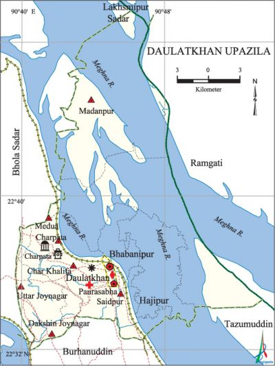
Daulatkhan Upazila
Daulatkhan Upazila (bhola district) area 316.99 sq km, located in between 22°32' and 22°48' north latitudes and in between 90°40' and 90°53' east longitudes. It is bounded by bhola sadar and lakshmipur sadar upazilas on the north, burhanuddin and tazumuddin upazilas on the south, ramgati upazila on the east and Bhola Sadar upazila on the west.
Population Total 173253; male 90670, female 82583; Muslim 168823, Hindu 4401 and others 29.
Water bodies Main river: meghna.
Administration 'Daulatkhan Thana was formed in 1872 and it was turned into an upazila on 1 August 1983.
| Upazila | ||||||||
| Municipality | Union | Mouza | Village | Population | Density (per sq km) | Literacy rate (%) | ||
| Urban | Rural | Urban | Rural | |||||
|
1 |
9 |
47 |
27 |
30540 |
142713 |
547 |
40.6 |
36.5 |
| Municipality | ||||||||
|
Area |
Ward |
Mahalla |
Population |
Density |
Literacy rate (%) | |||
|
2.6 |
9 |
9 |
14401 |
5539 |
46.10 | |||
| Upazila Town | ||||||||
|
Area |
Mouza |
Population |
Density |
Literacy rate (%) | ||||
|
7.49 |
1 |
16139 |
2155 |
35.50 | ||||
| Union | ||||
| Name of union and GO code | Area (acre) | Population | Literacy rate (%) | |
| Male | Female | |||
|
Uttar Joynagar 76 |
7255 |
15210 |
13348 |
41.40 |
|
Char Khalifa 19 |
4353 |
14297 |
14164 |
33.46 |
|
Char Pata 28 |
5641 |
11319 |
11234 |
35.24 |
|
Dakshin Joynagar 85 |
5073 |
10495 |
9412 |
37.67 |
|
Bhabanipur 16 |
4339 |
6253 |
5727 |
28.40 |
|
Madanpur 47 |
13371 |
2318 |
1635 |
32.23 |
|
Medua 57 |
14329 |
5673 |
4451 |
38.98 |
|
Saidpur 95 |
6467 |
16263 |
14694 |
37.40 |
|
Hajipur 38 |
10651 |
1281 |
1078 |
36.97 |
Source Bangladesh Population Census 2001, Bangladesh Bureau of Statistics.

Archaeological heritage Charpata Daira Jami Mosque (18th century).
History of the War of Liberation During the war of liberation in 1971, the Pak army conducted heavy plundering, genocide and set many houses on fire in the upazila. The Pak army brutally killed Abdul Hamid, the then circle officer of Daulatkhan, and his wife in presence of their children.
Religious institutions Mosque 311, temple 10.
Literacy rate and educational institutions Average literacy 37.3%; male 39%, female 35.4%. Educational institutions: college 2, secondary school 21, primary school 99, kindergarten 3, madrasa 28. Noted educational institutions: Daulatkhan Abu Abdullah College (1983), Halima Khatun Girls' School and College (1993), Daulatkhan Government High School (1916), Daulatkhan Govt. Girls' High School (1968), Hajipur Senior Madrasa (1912).
Newspapers and periodicals Monthly Shymali (defunct).
Cultural organisations Library 12, club 41, cinema hall 4, cultural society 4, theatre group 1, playground 50.
Main sources of income Agriculture 56.43%, non-agricultural labourer 4.91%, industry 0.67%, commerce 16.82%, transport and communication 3.33%, service 6.58%, construction 2.72%, religious service 0.31%, rent and remittance 0.60% and others 7.63%.
Ownership of agricultural land Landowner 44.77%, landless 55.23%; agricultural landowner: urban 21.35% and rural 49.57%.
Main crops Paddy, betel leaf, wheat, sweet potato, chilli, pulse, mustard, vegetables.
Extinct or nearly extinct crops Sesame, linseed.
Main fruits Mango, jackfruit, banana, papaya, palm, coconut, betel nut, water-melon.
Fisheries, dairies and poultries Fishery 47, dairy 55, poultry 71.
Communication facilities Pucca road 105.17 km, semi-pucca road 4.15 km, mud road 254.02 km.
Extinct or nearly extinct traditional transport Palanquin, bullock cart.
Noted manufactories Ice factory, welding factory.
Cottage industries Weaving, goldsmith, potteries, blacksmith, wood work, bamboo work.
Hats, bazars and fairs Daulatkhan Hat, Khaer Hat, Bangla Bazar, Chaltatlir Hat, Miar Hat, Houladarer Hat, Kazir Hat are notable.
Main exports Fish, betel leaf, betel nut, coconut, vegetables.
Access to electricity All the wards and unions of the upazila are under rural electrification net-work. However 16.27% (urban 17.60% and rural 16%) of the dwelling households have access to electricity.
Sources of drinking water Tube-well 72.85%, tap 0.12%, pond 2.06% and others 24.97%.
Sanitation 38.92% (urban 42.78% and rural 38.13%) of dwelling households of the upazila use sanitary latrines and 53.60% (urban 51.09% and rural 54.11%) of dwelling households use non-sanitary latrines; 7.48% of households do not have latrine facilities
Health centres Upazila health complex 1, satellite clinic 1, union health and family welfare centre 9, community clinic 17.
NGO activities brac, asa, proshika, Swanirvar Bangladesh, HEED Bangladesh. [Syed Mujtaba Ahmed Khan]
References Bangladesh Population Census 2001, Bangladesh Bureau of Statistics; Cultural survey report of Daulatkhan Upazila 2007.
