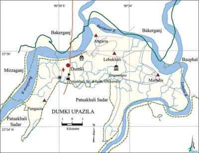
Dumki Upazila
Dumki Upazila (patuakhali district) area of 92.46 sq km, located in between 22°23' and 22°30' north latitudes and in between 90°17' and 90°27' east longitudes. It is bounded by bakerganj upazila on the north, patuakhali sadar and Bauphal upazilas on the south, bauphal upazila on the east, mirzaganj upazila on west.
Population 70705; male 35209, female 35496; Muslim 64634, Hindu 5996, Buddhist 51 and others 24.
Main rivers Lohalia, Rajaganj and Burishwar.
Administration Dumki Upazila was established in 2000.
| Upazila | ||||||||
| Municipality | Union | Mouza | Village | Population | Density (per sq km) | Literacy rate (%) | ||
| Urban | Rural | Urban | Rural | |||||
|
- |
4 |
21 |
24 |
10640 |
60065 |
765 |
78.6 |
63.8 |
| Upazila Town | ||||||||
|
Area (sq km) |
Mouza |
Population |
Density (per sq km) |
Literacy rate (%) | ||||
|
8.57 |
2 |
10640 |
1242 |
78.59 | ||||
| Union | |||||
| Name of union and GO code | Area (Acre) | Population | Literacy rate (%) | ||
| Male | Female | ||||
|
Angaria 4 |
4037 |
5607 |
6333 |
65.38 | |
|
Pangashia 88 |
4921 |
6480 |
6752 |
62.57 | |
|
Muradia 81 |
6863 |
7714 |
8072 |
66.92 | |
|
Lebukhali 47 |
7215 |
15408 |
14339 |
67.34 | |
Source Bangladesh Population Census 2001, Bangladesh Bureau of Statistics.

Religious institutions Mosque 197, temple 38.
Literacy rate and educational institutions Average literacy 66%; male 70.2%, female 62%. Educational institutions: university 1, college 5, secondary school 22, primary school 56, madrasa 22. Noted educational institutions: Patuakhali University of Science and Technology (2001), Janata College (1985), Nasima Keramat Ali Girls' College (1998), Muradia Secondary School (1928), Dumki Afsunnesa Khatun Secondary School (1966), Lebukhali Habibullah Secondary School (1968), Angaria Secondary School (1977), Pangashia Nesaria Aliya Madrasa (1919).
Main sources of income Agriculture 43.10%, non-agricultural labourer 4.66%, industry 0.92%, commerce 14.62%, transport and communication 3.01%, service 18.17%, construction 3.20%, religious service 0.30%, rent and remittance 0.62% and others 11.40%.
Main crops Rice, potato, pulse, chilli.
Extinct or nearly extinct crops Kaun.
Main fruits Banana, jackfruit, watermelon, papaya.
Hats, bazars and fairs 50.
Communication facilities Pucca road 7.30 km, mud road 298 km.
Extinct or nearly extinct traditional transport Palanquin.
Cottage industries Bamboo and cane work, weaving.
Access to electricity All the unions of the upazila are under rural electrification net-work. However 22.66% (urban 38.55% and rural 20.27%) of the dwelling households have access to electricity.
Sources of drinking water Tube-well 92.16%, pond 4.62%, tap 0.08% and others 3.14%.
Sanitation 21.27% (rural 23.16% and urban 8.74%) of the dwelling households use sanitary latrines and 63.41% (rural 61.75% and urban 74.39%) use non-sanitary latrines; 15.32% of the dwelling households do not have latrine facilities.
Natural disasters The devastating cyclone of 1584, 1822, 1960, 1961 and the flood of 1970 caused huge loss of lives and properties.
NGO activities Operationally important NGOs are asa, brac. [Tanvir Ahsan Tariq]
References Bangladesh Population Census 2001, Bangladesh Bureau of Statistics, Cultural survey report of Dumki Upazila 2007.
