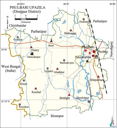
Phulbari Upazila (Dinajpur District)
Phulbari Upazila (dinajpur district) area 229.55 sq km, located in between 25°17' and 25°32' north latitudes and in between 88°44' and 89°01' east longitudes. It is bounded by parbatipur and chirirbandar upazilas on the north, birampur upazila on the south, nawabganj (dinajpur) and Birampur upazilas on the east, west bengal state of India on the west.'
Population Total 151939; male 78803, female 73136; Muslim 126044, Hindu 20827, Buddhist 2335, Christian 63 and others 2670.
Water bodies Main river: little jamuna.
Administration Phulbari Thana was formed in 1857 and it was turned into an upazila in 1984.
| Upazila | ||||||||
| Municipality | Union | Mouza | Village | Population | Density (per sq km) | Literacy rate (%) | ||
| Urban | Rural | Urban | Rural | |||||
|
1 |
7 |
158 |
151 |
27743 |
124196 |
662 |
56.1 |
46.4 |
| Municipality | ||||||||
|
Area (sq km) |
Ward |
Mahalla |
Population |
Density (per sq km) |
Literacy rate (%) | |||
|
16.05 |
9 |
14 |
27743 |
1728 |
56.1 | |||
| Union | ||||
| Name of union and GO code | Area (acre) | Population | Literacy rate (%) | |
| Male | Female | |||
|
Aladipur 25 |
7780 |
8960 |
8163 |
47.67 |
|
Eluary 47 |
9759 |
10750 |
10000 |
49.57 |
|
Kazihal 66 |
9127 |
9436 |
8710 |
51.15 |
|
Khayerbari 76 |
3490 |
4584 |
4486 |
46.31 |
|
Betdighi 28 |
8504 |
10062 |
9600 |
44.99 |
|
Daulatpur 38 |
5002 |
6498 |
6047 |
44.44 |
|
Shibnagar 84 |
9098 |
14203 |
12697 |
41.91 |
Source Bangladesh Population Census 2001,Bangladesh Bureau of Statistics.

Archaeological heritage and relics Damodarpur City, Garh Govinda.
Historical events In 1947 tebhaga movement' was held under the leadership of Shamsuddin Ahmed and Rup Narayan in this upazila. On 29 March 1971, an encounter was held between the freedom fighters and the Pak army on the Dinajpur road in which the freedom fighters destroyed a number of military vehicles and captured huge amount of supplies including arms and ammunitions of the Pak army.
Marks of the War of Liberation Mass grave and mass killing site 1 (Barai); memorial monument 1 (at the premises of Sujapur High School).
Literacy rate and educational institutions Average literacy 48.2%; male 52.1%, female 44%. Educational institutions: college 6, vocational centre 8, secondary school 44, primary school 102, madrasa 18. Noted educational institutions: Daulatpur Girls' High School (1912), Ramchandrapur Girls' High School (1913), Rajarampur SU High School (1913), Rudrani High School (1915), Sujapur High School (1919), Phulbari GM Pilot High School (1920), Phulbari DS Fazil Madrasa.
Newspapers and periodicals Weekly: Janamat (defunct).
Cultural organisations Library 1, club 41, jatra party 2, cinema hall 4.
Main sources of income Agriculture 68.83%, non-agricultural labourer 2.98%, industry 0.9%, commerce 12.41%, transport and communication 3.73%, service 5.55%, construction 0.65%, religious service 0.2%, rent and remittance 0.17% and others 4.58%.
Ownership of agricultural land Landowner 50.29%, landless 49.71%; agricultural landowner: urban 44.41% and rural 51.53%.
Main crops Paddy, wheat, jute, sugarcane, potato, pulse, oil seed, vegetables.
Extinct or nearly extinct crops Aus paddy, bhadai paddy, betel leaf, tobacco.
Main fruits Mango, banana, jackfruit.
Fisheries, dairies and poultries Dairy 125, poultry 105.
Communication facilities Pucca road 70 km, mud road 450 km; railway 16 km.
Extinct or nearly extinct traditional transport Palanquin, bullock cart.
Noted manufactories Rice mill, saw mill, oil mill, ice factory, printing press.
Cottage industries Goldsmith, potteries, bamboo work, wood work.
Hats, bazars and fairs Hats and bazars are 48, fairs 3, most noted of which are Phulbari Bazar Hat, Barai Hat, Ambari Hat, Amdungi Hat, Atpukur Hat, Madila Hat, Phulbari Mela.
Main exports Paddy, wheat, banana.
Access to electricity All the wards and unions of the upazila are under rural electrification net-work. However 22.88% of the dwelling households have access to electricity.
Natural resources' Coal mine has been discovered in this upazila in 1997.
Sources of drinking water Tube-well 94.67%, tap 0.51%, pond 0.2% and others 4.62%.
Sanitation 15.77% (rural 10.12% and urban 42.56%) of dwelling households of the upazila use sanitary latrines and 20.04% (rural 19.57% and urban 22.23%) of dwelling households use non-sanitary latrines; 64.19% of households do not have latrine facilities.
Health centres Hospital 1, upazila health complex 1, union health and family planning centre 6, clinic 2.
NGO activities Operationally important NGOs are brac, asa, thengamara mahila sabuj sangha. [Md. Rezaul Karim]
References Bangladesh Population Census 2001, Bangladesh Bureau of Statistics; Cultural survey report of Phulbari Upazila 2007.
