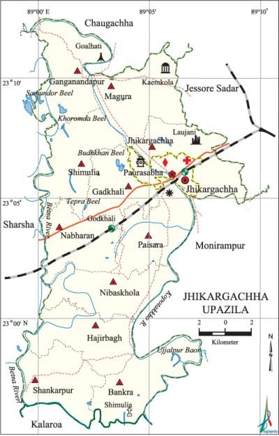
Jhikargachha Upazila
Jhikargachha Upazila (jessore district) area 308.09 sq km, located in between 23°00' and 23°10' north latitudes and in between 89°00' and 89°10' east longitudes. It is bounded by chaugachha upazila on the north, manirampur and kalaroa upazilas on the south, jessore sadar and Manirampur upazilas on the east, sharsha upazila on the west.
Population Total 271014; male 138507, female 132507; Muslim 254437, Hindu 14023, Buddhist 2277 and others 277.
Water bodies Main rivers: kobadak, betna; Khoromda Beel, Samundar Beel, Budhkhan Beel, Tepra Beel, Ujjalpur Baor are notable.
Administration Jhikargachha Thana was formed in 1909 and it was turned into an upazila in 1983. Jhikargachha Municipality was formed in 1988.
| Upazila | ||||||||
| Municipality | Union | Mouza | Village | Population | Density (per sq km) | Literacy rate (%) | ||
| Urban | Rural | Urban | Rural | |||||
|
1 |
11 |
164 |
174 |
35872 |
235142 |
880 |
59.32 |
50.86 |
| Municipality | ||||||||
|
Area |
Ward |
Mahalla |
Population |
Density |
Literacy rate (%) | |||
|
9.42 |
9 |
14 |
27834 |
2955 |
60.88 | |||
| Upazila Town | ||||||||
|
Area |
Mouza |
Population |
Density |
Literacy rate (%) | ||||
|
10.85 |
4 |
8038 |
741 |
53.90 | ||||
| Union | ||||
| Name of union and GO code | Area (acre) | Population | Literacy rate (%) | |
| Male | Female
| |||
|
Ganganandapur 29 |
7601 |
11591 |
10957 |
44.43 |
|
Gadkhali 35 |
6273 |
12103 |
11657 |
54.32 |
|
Jhikargachha 47 |
7983 |
12494 |
11602 |
54.86 |
|
Nabharan 59 |
6336 |
13673 |
13103 |
50.67 |
|
Nibaskhola 65 |
6661 |
10442 |
10208 |
50.51 |
|
Panisara 71 |
6532 |
10023 |
9820 |
50.42 |
|
Bankra 25 |
6716 |
10564 |
10238 |
48.67 |
|
Magura 53 |
7512 |
12059 |
11686 |
54.18 |
|
Shankarpur 83 |
6215 |
11177 |
10799 |
48.78 |
|
Shimulia 89 |
7149 |
9638 |
9242 |
51.99 |
|
Hajirbagh 41 |
6951 |
10370 |
9734 |
50.83 |
Source Bangladesh Population Census 2001, Bangladesh Bureau of Statistics.

Archaeological heritage and relics Remnants of the Rajbari of Mukut Roy at Laujani (12th century), Dargah Jami Mosque of Gazi Kalu (Kayemkola, Magura), Church of Our Lady of the Rojari (Shimulia).
History of the War of Liberation In the month of April 1971 the Pak army brutally killed many people at Krishnapur. bir srestha nur mohammad sheikh was killed on 5 September at village Goalhati (Ganganandapur union) in an encounter with the Pak army. Jhikargachha was liberated on 6 December.
Marks of the War of Liberation Mass killing site 1 (Goalhati), memorial monument 1.
Religious institutions Mosque 305, temple 17, church 4. Noted religious institutions: Kayemkola Mosque, Kali Mandir at Gadkhali.
Literacy rate and educational institutions Average literacy 51.99%; male 56.49%, female 47.32%. Noted educational institutions: Shahid Mosiur Rahman Degree College (1968), ML High School (1888), Raghunathnagar Secondary School (1922), BM High School (1936), Ganganandapur Secondary School (1940), Jhikargachha Pilot Secondary Girls' School (1953), Gazir Dargah Fazil Madrasa (1955).
Newspapers and periodicals Weekly: Mazlum, Kabadak, Swaadhin Bangla, Sonar Desh; periodical: Amrita Probahini (defunct).
Cultural organisations Library 3, club 58, cinema hall 3, playground 2, theatre group 5, opera party 1.
Main sources of income Agriculture 65.97%, non-agricultural labourer 2.97%, industry 2.09%, commerce 12.84%, transport and communication 3.72%, service 4.03%, construction 1.35%, religious service 0.11%, rent and remittance 1.53% and others 5.15%.
Ownership of agricultural land Landowner 59.34%, landless 40.66%; agricultural landowner: urban 48.15% and rural 61.01%.
Main crops Paddy, jute, mustard, pulse, wheat, potato, cotton, tuberose, vegetables.'
Extinct or nearly extinct crops Varieties of pulse.
Main fruits Mango, jackfruit, blackberry, papaya, litchi, coconut, banana, betel nut.
Communication facilities Pucca road 171.13 km, semi-pucca road 38 km, mud road 589.92 km; railway 15.5 km; waterway 25 nautical miles.
Extinct or nearly extinct traditional transport Palanquin, bullock cart.
Noted manufactories Cold storage 2, bidi factory 1.
Cottage industries Goldsmith, blacksmith, potteries, weaving, tailoring, wood work.
Hats, bazars and fairs Jhikargachha, Chhutipur, Kayemkola and Bankra bazars are notable.
Main exports Coconut, betel nut, tuberose, potato, vegetables, cotton, bidi.
Access to electricity All the wards and unions of the upazila are under rural electrification net-work. However 30.39%' of the dwelling households have access to electricity.
Sources of drinking water Tube-well 96.18%, tap 0.57%, pond 0.18% and others 3.07%.
Sanitation 31.34% (rural 42.49% and urban 29.68%) of dwelling households of the upazila use sanitary latrines and 38.47% (rural 42.97% and urban 37.80%) of dwelling households use non-sanitary latrines; 30.19% of households do not have latrine facilities.
Health centres Upazila health complex 1, health and family planning centre 11, upazila health centre 3.
NGO activities Operationally important NGOs are brac, asa, caritas. [Firoj Ansari]
References Bangladesh Population Census 2001, Bangladesh Bureau of Statistics; Cultural survey report of Jhikargachha Upazila 2007.
