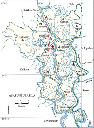
Assasuni Upazila
Assasuni Upazila (satkhira district) area 402.36 sq km, located in between 22°21' and 22°40' north latitudes and in between 89°03' and 89°17' east longitudes. It is bounded by satkhira sadar and tala upazilas on the north, shyamnagar upazila on the south, paikgachha and koyra upazilas on the east and kaliganj and debhata upazilas on the west.
Population Total 249244; male 126399, female 122845; Muslim 177199, Hindu 70483, Buddhist 1298, Christian 133 and others 131. Munda, Chandal or Podh and Kaibarto tribal communities are belong to this upazila.
Water bodies Main rivers: kobadak, Betna, Kholpetua; Puinjala and Cheutia canals are notable.
Administration Assasuni Thana was formed in 1891 and it was turned into an upazila in 1983.
| Upazila | ||||||||
| Municipality | Union | Mouza | Village | Population | Density (per sq km) | Literacy rate (%) | ||
| Urban | Rural | Urban | Rural | |||||
|
- |
11 |
143 |
242 |
8516 |
240728 |
619 |
45.10 |
40.13 |
| Upazila Town | ||||||||
|
Area (sq km) |
Mouza |
Population |
Density |
Literacy rate (%) | ||||
|
6.81 |
2 |
8516 |
1251 |
45.10 | ||||
| Union | ||||
| Name of union and GO code | Area (acre) | Population | Literacy rate (%) | |
| Male | Female | |||
|
Anulia 8 |
7054 |
11082 |
10960 |
32.79 |
|
Assasuni 17 |
8262 |
11516 |
10942 |
44.66 |
|
Kadakati 56 |
- |
6605 |
6167 |
44.87 |
|
Kulla 69 |
7883 |
11277 |
10612 |
36.16 |
|
Khajra 60 |
9201 |
12584 |
12935 |
39.62 |
|
Durgapur 43 |
12856 |
8281 |
8401 |
37.37 |
|
Pratap Nagar 77 |
8372 |
12532 |
13400 |
35.17 |
|
Baradal 25 |
9008 |
13623 |
13298 |
43.46 |
|
Budhhata 34 |
8285 |
12919 |
11833 |
43.02 |
|
Sreeula 94 |
10297 |
11941 |
11745 |
40.79 |
|
Sobhnali 86 |
11799 |
14039 |
12552 |
44.96 |
Source Bangladesh Population Census 2001, Bangladesh Bureau of Statistics.
Archaeological heritage and relics Dargah of Buro Pir, Budhhata Shiva Kali Mandir, three-domed jami mosque at Shreeula and Mazar of Hazrat Shah Aziz (R).
History of the War of Liberation On 14 August 1971 the freedom fighters damaged a Pakistani ship, loaded with arms and ammunitions, at Mongla port, by mine explosion. Freedom fighters Aftab and Sirajul Islam were killed and Imdadul Hoque, Mujibor Rahman, Khalil and Imam Bari were wounded on 15 August in an encounter with the rajakars at Budhhata. On 16 August three freedom fighters were killed while launching a attack on two gun boats at river Kholpetua. Freedom fighter Manaranjan was killed and a number of rajakars were killed or wounded in an encounter at village Goaldanga on 17 September 1971. Besides, many rajakars were killed or wounded in September when the freedom fighters attacked the Chapra Rajakar camp.

Marks of the War of Liberation Mass killing site 1 (Keyargati).
Religious institutions Mosque 200, tomb 4, temple 74, church 2. Noted religious institutions: Budhata Jami Mosque, Baradal Church, Shah Abdul Aziz (R) Tomb.'
Literacy rate and educational institutions Average literacy 40.30%; male 47.97%, female 32.51%. Educational institutions: college 2, secondary school 34, primary school 148, community primary school 7, satellite school 43, NGO education centre 30, madrasa 19. Noted educational institutions: Assasuni College (1969), Sreeula Secondary School (1881), Budhata B.B.M High School (1925), Assasuni Secondary School (1940), Pratap Nagar ABS Fazil Madrasa (1952).
Newspapers and periodicals Monthly: Pralagav; quarterly: Pratya, Shradhanjali; defunct: Jagarani.
Cultural organizations Club 46, library 1, theatre group 2, cinema hall 1, opera party 1, literary society 1.
Main sources of income Agriculture 63.11%, non-agricultural labourer 5.12%, commerce 16.98%, transport and communication 1.74%, industry 0.96%, service 3.56%, construction 0.62%, religious service 0.24%, rent and remittance 0.14% and others 7.53%.
Ownership of agricultural land Landowner 58.34%, landless 41.66%; agricultural landowner: urban 39.56% and rural 59.08%.
Main crops Paddy, jute, potato, wheat, pulses, sugarcane, vegetables.
Extinct or nearly extinct crops Linseed, sesame, sweet potato, mungbean, khesari.
Main fruits Mango, jackfruit, black berry, plum.
Fisheries, dairies and poultries This upazila has a number of fisheries, poultries, shrimps hatcheries.
Communication facilities Pucca road 46.40 km, mud road 462.66 km.
Extinct or nearly extinct traditional transport Palanquin, boat, horse carriage.
Manufactories Rice mill, ice factory.
Noted Hats, bazars and fairs Budhhata Hat, Mahishkur Bazar and Barada Bazar.
Main exports Shrimp, betel leaf, madur, plum, arum
Access to electricity All the unions of the upazila are under rural electrification net-work. However 9.70% dwellings have access to electricity.
Sources of drinking water Tube-well 81.84%, pond 13.56%, tap 1.03% and others 3.57%. Presence of arsenic in shallow tube-well water of the upazila is excessive. In a research conducted by BGS and DP H in 2001 it known that the average presence of arsenic in shallow tube-well' is 133 microgram. However, about 67% of tube-well water contain arsenic more than 150 microgram.
Sanitation 40.91% (rural 40.05% and urban 62.77%) of dwelling households of the upazila use sanitary latrines and 44.40% (rural 45.05% and urban 27.73%) of dwelling household use non-sanitary latrines; 14.69% of households do not have latrine facilities.'
Health centers Upazila health complex 1, rural health center 1, family welfare center 7.
'Natural Disasters The famine 1770 (Siyatturer Manvantar), 1886, 1898-98, 1921, 1943 and 1974 are notable. The famine of 1921 is known as 'Sundarban Famine'; besides an earthquake was occurred in 1897 and on 29 November 1988 a devastating cyclone caused a huge number of damages in the region.
NGO brac, asa, care, Rupantar, Pallichetona, Raktakarabi, Assasuni Development Organisation. [Sachhida Nanda De]
References Bangladesh Population Census 2001, Bangladesh Bureau of Statistics; Cultural survey report of Assasuni Upazila 2007.
