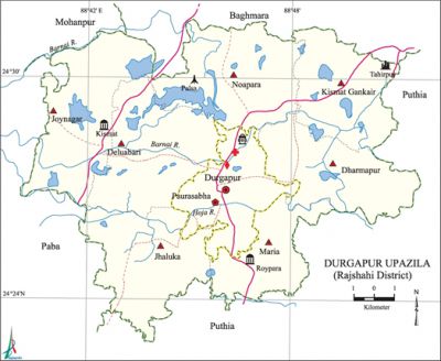
Durgapur Upazila (Rajshahi District)
Durgapur Upazila (RAJSHAHI DISTRICT) area 195.03 sq km, located in between 24°23' and 24°32' north latitudes and in between 88°40' and 88°52' east longitudes. It is bounded by baghmara and mohanpur upazilas on the north, puthia upazila on the south and east, paba upazila on the west.
Population Total 167596; male 86363, female 81233; Muslim 162856, Hindu 4064, Buddhist 529 and others 147. Indigenous communities such as oraon and santals belong to this upazila.
Water bodies Hoja and Barnai rivers and' Angrar Beel, Kayamjampur Beel, Anulia Beel, Dahar Beel, Kaliar Padma Beel, Khaliar beel are notable.
Administration Durgapur Thana was formed in 1909 and it was turned into an' upazila in 1984.
| Upazila | ||||||||
| Municipality | Union | Mouza | Village | Population | Density (per sq km) | Literacy rate (%) | ||
| Urban | Rural | Urban | Rural | |||||
|
1 |
7 |
114 |
123 |
6871 |
160725 |
859 |
55.6 |
55.2 |
| Upazila Town | ||||||||
|
Area (sq km) |
Mouza |
Population |
Density (per sq km) |
Literacy rate (%) | ||||
|
5.69 |
4 |
6871 |
1208 |
40.86 | ||||
| Union | ||||
| Name of union and GO code | Area (acre) | Population | Literacy rate (%) | |
| Male | Female | |||
|
Kismat Gankair 59 |
6073 |
10254 |
9451 |
37.85 |
|
Joynagar 47 |
7356 |
12870 |
12081 |
41.70 |
|
Jhaluka 35 |
6607 |
11847 |
11181 |
36.44 |
|
Deluabari 11 |
8013 |
13288 |
12572 |
39.24 |
|
Dharmapur (Pananagar) 23 |
8080 |
13959 |
13185 |
50.16 |
|
Noapara 83 |
6563 |
12787 |
12254 |
39.18 |
|
Maria 71 |
5502 |
11358 |
10509 |
40.43 |
Source Bangladesh Population Census 2001, Bangladesh Bureau of Statistics.

Archeological heritage and relics Kismat Mosque (Maria, eighteenth century), Roypara Jami Mosque (sixteenth century), Panchubari five domed Jami Mosque, Kali Mandir (Kalidaha), ruins of Neel Kuthi (Pananagar and Bakhtiarpur).
History of the War of Liberation In 1971 a battle was fought between the freedom fighters and the Pak army at Kabasmul (boarder of Paba-Durgapur) in which a Pak army Major was killed; in retaliation the Pak army killed 44 innocent villagers of Gaganbaria and Palsa.
Marks of War of Liberation Mass killing and memorial statue at the playground of Palsa School.
Religious institutions Mosque 338, temple 14, church 1, sacred place 1. Noted religious institutions: Kismat Mosque (Maria), Roypara Jami Mosque, Panchubari Five Domed Jami Mosque, Kali Mandir (Kalidaha).
Literacy rate and educational institutions Average literacy 41%; male 46.8% female 34.8%. Educational institutions: College 9, technical college 3, secondary school 43, primary school 77, madrasa 19. Noted educational institutions: Durgapur Pilot High School (1946), Daudkandi High School (1946), Sreedhar Govt. Primary School (1857), Singa Govt. Primary School (1923).
Cultural organisations Library 1, club 25, theater group 1, cinema hall 1, women's organisation 1, playground 25.
Main sources of income Agriculture 79.85%, non-agricultural labourer 2.14%, industry 0.24%, commerce 7.92%, transport and communication 2.81%, service 3%, construction 0.45%, religious service 0.09%, rent and remittance 0.09% and others 3.41%.
Ownership of agricultural land Landowner 68.77%, landless 31.23%; agricultural landowner: urban 60.27%' and rural 69.11%.
Main crops Paddy, wheat, potato, betel nut, mulberry, vegetables.
Extinct or nearly extinct crops Sesame, mustard seed, sweet potato, kaun, linseed, arahar.
Main fruits Mango, jackfruit, banana, papaya, litchi, date.
Fisheries, dairies and poultries Fishery 50, poultry 20, hatchery 25.
Communication facilities Pucca road 115 km, semi-pucca road 5.17 km, mud road 430.88 km.
Extinct or nearly extinct traditional transport Palanquin, horse carriage and bullock cart.
Noted manufactories Flour mill, rice mill, saw mill, printing press, ice factory, welding factory, bidi factory.
Cottage industries Blacksmith, potteries, weaving, bamboo work.
Hats, bazars and fairs Hats and bazars are 16, fairs 3, most noted of which are Durgapur Bazar, Daudkandi Bazar, Pananagar Bazar, Kanpara Hat,' Baruni Snan Mela (Kalidaha), Tebila Muharram Mela (Pananagar), Lakshmipur Ghoradaha Mela.
Main exports Betel nut, banana, papaya, date molasses, flour, vegetables.
Access to electricity All the wards and unions of the upazila are under rural electrification net-work. However 27.99% of the dwelling households have access to electricity.
Sources of drinking water Tube-well 97.08%, tap 0.24%, pond 0.08% and others 2.60%.
Sanitation 25.99% (rural 24.90% and urban 52.95%) of dwelling households of the upazila use sanitary latrines and 47.08% (rural 47.56% and urban 35.21%) of dwelling households use non-sanitary latrines; 26.93% of households do not have latrine facilities.
Health centres Upazila health complex 1, health centre 7, family planning centre 7, satellite clinic 2, clinic 2.'
NGO activities brac, asa, caritas, thengamara mahila sabuj sangha, Barendra. [AKM Kaisaruzzaman]
References Bangladesh Population Census 2001, Bangladesh Bureau of Statistics; Cultural survey report of Durgapur Upazila 2007.
