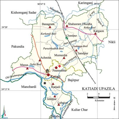
Katiadi Upazila
Katiadi Upazila (kishoreganj district) area 219.22 sq km, located in between 24°10' and 24°22' north latitudes and in between 90°43' and 90°55' east longitudes. It is bounded by kishoreganj sadar and karimganj upazilas on the north, belabo and monohardi upazilas on the south, nikli, bajitpur and kuliar char upazilas on the east, pakundia upazila on the west.
Population Total' 282297; male 141477, female 140820; Muslim 270956, Hindu 11164 and others 157.
Water bodies Main rivers: old brahmaputra, Mangalhat, Suti, Singura; Purushbadhia, Doba Kurkandi, Dodanga and Reksa beels are notable.
Administration Katiadi Thana was formed in 1897 and it was turned into an upazila in 1983.
| Upazila | ||||||||
| Municipality | Union | Mouza | Village | Population | Density (per sq km) | Literacy rate (%) | ||
| Urban | Rural | Urban | Rural | |||||
|
1 |
10 |
97 |
170 |
12795 |
269502 |
1272 |
55.2 |
37.0 |
| Upazila Town | ||||||||
|
Area (sq km) |
Mouza |
Population |
Density (per sq km) |
Literacy rate (%) | ||||
|
2.74 |
3 |
12795 |
467055.2 |
- | ||||
| Union | ||||
| Name of union and GO code | Area (acre) | Population | Literacy rate (%) | |
| Male | Female | |||
|
Achmita 09 |
5353 |
14358 |
14268 |
33.39 |
|
Katiadi 57 |
4783 |
17440 |
17129 |
42.03 |
|
Kargaon 47 |
8200 |
14103 |
14083 |
24.05 |
|
Chandpur 28 |
6152 |
14296 |
14297 |
43.34 |
|
Jalalpur 38 |
3004 |
10991 |
11014 |
43.09 |
|
Banagram 19 |
6297 |
16598 |
16424 |
43.34 |
|
Masua 76 |
4930 |
15507 |
15479 |
44.86 |
|
Mumurdia 85 |
5432 |
12774 |
12471 |
42.16 |
|
Lohajuri 66 |
3245 |
10233 |
10175 |
38.03 |
|
Shahasram Dhuldia 95 |
6597 |
15177 |
15480 |
32.24 |
Source Bangladesh Population Census 2001, Bangladesh Bureau of Statistics.
Archaeological heritage and relics Tomb of Hazrat Shamsuddin (R), a companion of Hazrat Shahjalal (R) at village Kurikhai; Gopinath Jeu Mandir, Lakshmi Narayan Jeu Mandir (built during the time of Raja Navabanga Roy).'
Religious institutions Mosque 329, temple 2, tomb 2, akhra 2. Noted religious institutions: Kalamahal Jami Mosque, Kurikhai Dargah Jami Mosque, Katiadi Puratan Bazar Jami Mosque, Bethair Jami Mosque.

Literacy rate and educational institutions Average literacy 37.9%; male 39.9%, female 35.8%. Noted educational institutions: Katiadi Degree College, Dr. Abdul Mannan Mahila College, Achmita George Institution (1912), Nabagram Ananda Kishore High School (1922), Banagram Ananda Kishore High School (1912), Katiadi Pilot Boys' High School, Katiadi Pilot Girls' High School.
Newspapers and periodicals Monthly: Unmesh.
Main sources of income Agriculture 63.33%, non-agricultural labourer 3.48%, industry 0.94%, commerce 14.41%, transport and communication 2.28%, service 4.61%, construction 0.89%, religious service 0.20%, rent and remittance 1.41% and others 8.45%.
Ownership of agricultural land Landowner 53.97%, landless 46.03%; agricultural landowner: urban 34.21% and rural 54.85%.
Main crops Paddy, wheat, potato, sugarcane, jute, ground-nut, mustard, vegetables.
Extinct or nearly extinct crops Cotton, barley, sesame, kaun, linseed, aniseed, blackcumin.
Main fruits Mango, jackfruit, litchi, banana, papaya.
Fisheries, dairies and poultries This upazila has a number of fisheries, dairies and poultries.
Communication facilities Pucca road 66 km, semi-pucca road 8 km, mud road 249 km, railway 12.2 km.
Extinct or nearly extinct traditional transport Palanquin, horse carriage, bullock cart.
Noted manufactories Bidi factory 2, oil mill 4, incense factory 3, brick-field 1.
Cottage industries Weaving, potteries, bamboo work, blacksmith, wood work.
Hats, bazars and fairs Hats and bazars are 20, fairs 8, most noted of which are Katiadi, Dhukdia and Kargaon bazars, Rath Mela at Gopinath Jeo Temple and Sitala Mela.
''Main exports Jute.
Access to electricity All the wards and unions of the upazila are under rural electrification net-work. However 14.65% of the dwelling households have access to electricity.'
Sources of drinking water Tube-well 89.58%, pond 0.71%, tap 0.41% and others 9.30%.
Sanitation 26.13% (rural 25.03% and urban 50.95%) of dwelling households of the upazila use sanitary latrines and 40.57% (rural 41.07% and urban 29.37%) of dwelling households use non-sanitary latrines; 33.29% of households do not have latrine facilities.
Health centres Upazila health complex 1, family planning centre 8, palli satellite clinic 2.
Natural disasters The earthquake of 1918 caused heavy damages to settlements and other properties of the upazila. Besides, a large number of people were victims of the famine of 1943.
NGO activities Operationally important NGOs are brac, asa, proshika, Pratasha, Ahsania Mission, Palli Bikash. [Syed Md Saleh Uddin]
References Bangladesh Population Census 2001, Bangladesh Bureau of Statistics; Cultural survey report of Katiadi Upazila 2007.
