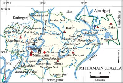
Mithamain Upazila
Mithamain Upazila (kishoreganj district) area 222.92 sq km, located in between 24°22' and 24°30' north latitudes and in between 91°00' and 91°15' east longitudes. It is bounded by itna and ajmiriganj upazilas on the north, austagram upazila on the south, baniachang and Austagram upazilas on the east, karimganj and nikli upazilas on the west.
Population Total 122200; male 63232, female 58968; Muslim 112767, Hindu 9312 and others 121.
Water bodies Main rivers: Dhanu, Kalai; Baragop, Gazaria, Deudori, Sreghor, Rati and Nikli beels are notable.
Administration Mithamain Thana was turned into an upazila in 1983.
| Upazila | ||||||||
| Municipality | Union | Mouza | Village | Population | Density (per sq km) | Literacy rate (%) | ||
| Urban | Rural | Urban | Rural | |||||
|
- |
7 |
59 |
133 |
12450 |
109750 |
548 |
51.6 |
29.5 |
| Upazila Town | ||||||||
|
Area (sq km) |
Mouza |
Population |
Density (per sq km) |
Literacy rate (%) | ||||
|
9.15 |
1 |
12450 |
1361 |
51.6 | ||||
| Union | ||||
| Name of union and GO code | Area (acre) | Population | Literacy rate (%) | |
| Male | Female | |||
|
Keorjori 67
|
7409
|
7092
|
6626
|
36.00
|
|
Khatkhal 54
|
5191
|
7712
|
7178
|
23.48
|
|
Gopedighi 40
|
9514
|
10686
|
10075
|
30.50
|
|
Ghagra 27
|
7508
|
11535
|
10915
|
29.55
|
|
Bairati
|
3676
|
4584
|
4266
|
35.71
|
|
Dhaki 13
|
10767
|
10796
|
10400
|
31.70
|
|
Mithamain 81
|
9005
|
10827
|
9508
|
42.55 |
Source Bangladesh Population Census 2001, Bangladesh Bureau of Statistics.

History of the War of Liberation On 1 November 1971 the Pak army abducted and brutally killed 28 persons at village Dhubajura and 3 persons at village Telikhai.
Marks of the War of Liberation Mass killing site 1 (Boira).
Religious institutions Mosque 105, temple 17, tomb 3, akhra 3. Noted religious institutions: tomb of Hazrat Shah Tamiz Uddin (R), dargah of Malik, Delhi Akhra, Ghagra Godhra Goswami' Akhra.
Literacy rate and educational institutions Average literacy 15.6%; male 20.7%, female 10.2%. Educational institutions: college 1, secondary school 8, primary school 76, community school 10, madrasa 25.
Cultural organisations Library 1, club 30.
Main sources of income Agriculture 82.48%, non-agricultural labourer 2.32%, industry 0.20%, commerce 7.26%, transport and communication 0.24%, service 2.33%, construction 0.56%, religious service 0.21%, rent and remittance 0.20% and others 4.20%.
Ownership of agricultural land Landowner 60.34%, landless 39.66%; agricultural landowner: urban 63.33% and rural 60%.
Main crops Paddy, mustard, potato, kherai, ground nut, vegetables.
Extinct or nearly extinct crops Linseed, sesame, kaun.
Fisheries, dairies and poultries Dairy 22, poultry 26.
Communication facilities Semi-pucca road 1.3 km, mud road 165 km; waterway 35 nautical miles.
Extinct or nearly extinct traditional transport Palanquin.
Noted manufactories Ice factory, bakery.
Cottage industries Goldsmith, blacksmith, potteries, wood work.
Hats, bazars and fairs Hats and bazars are 11, most noted of which are Mithamain Bazar, Gopedighi Bazar and Dhaki Bazar.
Main exports Paddy, ground nut, potato, kherai.
Access to electricity All the unions of the upazila are under rural electrification net-work. However 10.94%' of the dwelling households have access to electricity.
Sources of drinking water Tube-well 90.35%, tap 0.24%, pond 2.85% and others 6.56%. The presence of arsenic in an intolerable level has been detected in 20.5% of the shallow tube-well water of the upazila.
Sanitation 9.04% (rural 7.08% and urban 26.38%) of dwelling households of the upazila use sanitary latrines and 83.37% (rural 85.08% and urban 68.18%) of dwelling households use non-sanitary latrines; 7.59% of households do not have latrine facilities.
Health centres Upazila health complex 1, health and family planning centre 1, union satellite clinic 2, community clinic 14.
NGO activities Operationally important NGO is asa. [Mokarram Hussain Shokorana]
References Bangladesh Population Census 2001, Bangladesh Bureau of Statistics; Cultural survey report of Mithamain Upazila 2007.
