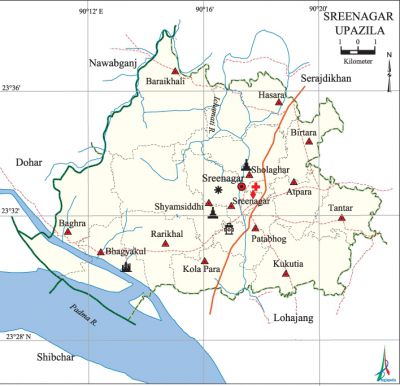
Sreenagar Upazila
Sreenagar Upazila (munshiganj district) area 202.98 sq km, located in between 23°27' and 23°38' north latitudes and in between 90°10' and 90°22' east longitudes. It is bounded by serajdikhan and nawabganj (dhaka) upazilas on the north, lohajang and shibchar upazilas on the south, Serajdikhan and Lohajang upazilas on the east, Nawabganj and dohar upazilas on the west.
Population Total 228771; male 114878, female 113893; Muslim 203366, Hindu 25338, Buddhist 38, Christian 16 and others 13.
Water bodies Main rivers: padma, ichamati.
Administration Sreenagar Thana was turned into an upazila in 1983.
| Upazila | ||||||||
| Municipality | Union | Mouza | Village | Population | Density (per sq km) | Literacy rate (%) | ||
| Urban | Rural | Urban | Rural | |||||
|
- |
14 |
102 |
148 |
10431 |
218340 |
1127 |
56.6 |
52.4 |
| Upazila Town | ||||||||
|
Area (sq km) |
Mouza |
Population |
Density (per sq km) |
Literacy rate (%) | ||||
|
1.99 |
2 |
10431 |
5242 |
56.6 | ||||
| Union | ||||
| Name of union and GO code | Area (acre) | Population | Literacy rate (%) | |
| Male | Female | |||
|
Atpara 06 |
2308 |
6276 |
5896 |
59.25 |
|
Kukutia 54 |
4088 |
7593 |
7920 |
52.64 |
|
Kola Para 47 |
2461 |
6877 |
7053 |
63.16 |
|
Tantar 94 |
2563 |
7269 |
7221 |
59.33 |
|
Patabhog 61 |
2102 |
6541 |
6431 |
57.14 |
|
Baghra 13 |
5896 |
10265 |
10088 |
48.37 |
|
Baraikhali 20 |
6410 |
9732 |
9509 |
52.81 |
|
Birtara 33 |
2168 |
5405 |
5357 |
46.08 |
|
Bhagyakul 27 |
2511 |
10614 |
11769 |
54.92 |
|
Rarikhal 67 |
3384 |
8315 |
8499 |
49.27 |
|
Sholaghar 81 |
3682 |
8609 |
8436 |
47.14 |
|
Shyamsiddhi 88 |
5049 |
7366 |
7343 |
46.79 |
|
Sreenagar 74 |
2419 |
10414 |
9288 |
51.03 |
|
Hasara 40 |
3709 |
9302 |
9083 |
51.71 |
Source Bangladesh Population Census 2001, Bangladesh Bureau of Statistics.

Archaeological heritage and relics Shyamsiddhir Math and Temple, Sholaghar Math, Bhagyakul Rajbari. Besides, sculpture, seal, copper plate, engraved granite pillar discovered from Vikrampur are now preserved in the National Museum.
History of the War of Liberation In the month of September 1971 a direct encounter was held between the freedom fighters and the Pak army in the Shibrampur canal of the upazila in which a number of Pak soldiers were killed; in this encounter three gun boats of the Pak army were also destroyed by the freedom fighters.
Religious institutions Mosque 369, temple 55, church 1.
Literacy rate and educational institutions Average literacy 52.6%; male 54.1%, female 52.2%. Educational institutions: college 4, vocational institute 1, secondary school 22, primary school 96, madrasa 31. Noted educational institutions: Hasara KK High School (1879), Bhagyakul Harendra Lal High School (1900), Beltali GJ High School (1901), Kukutia KK Institution (1904), Sholaghar AKSK Multilateral High School (1925), Baghra Swarup Chandra Pilot High School (1920), Rarikhal JG Basu Institution and College (1921), Rushdi High School (1924).
Cultural organisations Library 1, club 303, cinema hall 3, stadium 1.
Main sources of income Agriculture 36.12%, non-agricultural labourer 2.47%, industry 1.99%, commerce 23.60%, transport and communication 2.97%, service 12.83%, construction 3.01%, religious service 0.21%, rent and remittance 6.96% and others 9.84%.
Ownership of agricultural land Landowner 42.25%, landless 57.75%; agricultural landowner: urban 24.25% and rural 43.10%.
Main crops Paddy, potato, wheat, mustard, vegetables.
Main fruits Mango, guava, wood apple.
Fisheries, dairies and poultries Dairy 192, poultry 135, hatchery 1.
Communication facilities Pucca road 98 km, semi-pucca road 11 km, mud road 155 km; waterway 9 nautical miles.
Extinct or nearly extinct traditional transport Bullock cart.
Noted manufactories Rice mill, saw mill, dairy products, cold storage, brick field, welding factory.
Cottage industries Goldsmith, blacksmith, potteries, wood work.
Hats, bazars and fairs Hats and bazars are 22, fairs 3, most noted of which are Sreenagar Hat, Bhagyakul Hat, Kumargaon Hat, Kederpur Hat, Baraikhali Bazar, Hasara Bazar and Sholaghar Bazar.
Main exports Paddy, potato, vegetables.
Access to electricity All the unions of the upazila are under rural electrification net-work. However 60.03% of the dwelling households have access to electricity.
Sources of drinking water Tube-well 94.83%, tap 0.35%, pond 1.56% and others 3.26%. The presence of arsenic has been detected in shallow tube-well water of the upazila.
Sanitation 56.09% (rural 54.69% and urban 85.74%) of dwelling households of the upazila use sanitary latrines and 39.97% (rural 41.24% and urban 12.94%) of dwelling households use non-sanitary latrines; 3.94% of households do not have latrine facilities.
Health centres Upazila health complex 1, satellite clinic 3, pathological laboratory 3, family planning centre 10, veterinary hospital 1.
NGO activities Operationally important NGOs are brac, asa. [Md. Mosarraf Hossain Sarker]
References Bangladesh Population Census 2001, Bangladesh Bureau of Statistics; Cultural survey report of Sreenagar Upazila 2007.
