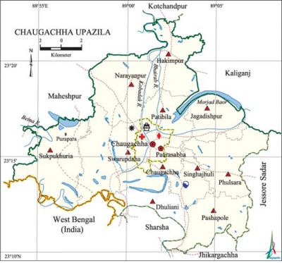
Chaugachha Upazila
Chaugachha Upazila (jessore district) area 269.20 sq km, located in between 23°10' and 23°22' north latitudes and in between 88°54' and 89°08' east longitudes. It is bounded by maheshpur, kotchandpur and kaliganj (jhenaidaha) upazilas on the north, sharsha and jhikargachha upazilas and west bengal state of India on the south, jessore sadar and Kaliganj (Jhenaidaha) upazilas on the east, Maheshpur upazila on the west.
Population Total 211065; male 109033, female 102032; Muslim 193955, Hindu 16872, Buddhist 72, Christian 16 and others 150.
Water bodies Main rivers: kobadak, betna and bhairab; Morjad Baor is notable.
Administration Chaugachha Thana was turned into an upazila in 1983.
| Upazila | ||||||||
| Municipality | Union | Mouza | Village | Population | Density (per sq km) | Literacy rate (%) | ||
| Urban | Rural | Urban | Rural | |||||
|
1 |
11 |
150 |
159 |
14589 |
196476 |
784 |
55.05 |
43.08 |
| Upazila Town | ||||||||
|
Area |
Mouza |
Population |
Density |
Literacy rate (%) | ||||
|
7.87 |
3 |
14589 |
1854 |
55.05 | ||||
| Union | ||||
| Name of union and GO code | Area (acre) | Population | Literacy rate (%) | |
| Male | Female | |||
|
Chaugachha 08 |
5036 |
11907 |
10916 |
48.45 |
|
Jagadishpur 34 |
4954 |
7875 |
7097 |
45.47 |
|
Dhuliani 17 |
3597 |
6584 |
6272 |
40.86 |
|
Narayanpur 51 |
8277 |
11446 |
10591 |
43.22 |
|
Patibila 69 |
5156 |
8373 |
7927 |
40.26 |
|
Pashapole 60 |
6414 |
9377 |
8794 |
42.55 |
|
Phulsara 77 |
6715 |
10942 |
10399 |
49.68 |
|
Singhajhuli 86 |
3452 |
6784 |
6563 |
45.67 |
|
Sukpukhuria 94 |
9221 |
12972 |
12116 |
41.47 |
|
Swarupdaha 43 |
9514 |
13038 |
12451 |
42.64 |
|
Hakimpur 25 |
6951 |
9735 |
8906 |
41.78 |
Source Bangladesh Population Census 2001, Bangladesh Bureau of Statistics.

Archaeological heritage and relics Neelkuthi, Kathbilla Shiva Mandir, Guatali Shiva Mandir, Mathchakla Jami Mosque
History of the War of Liberation On 20 November 1971, a fierce battle was fought between the Pak army and the allied forces at Jamtala, Jagannathpur and Garibpur playground in which a number of freedom fighters were killed and wounded. During the war of liberation this upazila was considered as the gateway toliberation. Chaugachha was liberated on 23 November 1971.
Marks of the War of Liberation Memorial monument 2 (Chaugachha and Masiurnagar).
Religious institutions Mosque 248, temple 18 and sacred place 1.
Literacy rate and educational institutions Average literacy 43.92%; male 39.30%, female 17.8%. Noted educational institutions: Chaugachha College (1972), Sadaat Pilot School (1928), Chaugachha Chhara Pilot Secondary Girls' School (1962), Narayanpur High School, Chaugachha High School, Saidpur Siddikia Dakhil Madrasa (1922), Chaugachha Madrasa (1940).
Cultural organisations Club 4, library 1, theatre group 1.
Important installation Cotton Development Centre (Jagadishpur).
Main sources of income Agriculture 72.94%, non-agricultural labourer 2.70%, industry 1%, commerce 10.68%, transport and communication 2.73%, service 3.89%, construction 0.88%, religious service' 0.09%, rent and remittance 0.66% and others 4.43%.
Ownership of agricultural land Landowner 65.45%, landless 34.55%; agricultural landowner: urban 48.91% and rural 66.16%.
Main crops Paddy, jute, sugarcane, cotton, wheat, potato, pulses, brinjal, patal, onion, garlic, bean, betel leaf.
Extinct or nearly extinct crops Sesame, linseed, arahar, sweet potato, kaun, groundnut, khesari, gram,' coriander.
Main fruits Mango, black berry, jackfruit, banana, papaya.
Fisheries, dairies and poultries This upazila has a number of fisheries, dairies, poultries and hatcheries.
Communication facilities Pucca road 40 km, semi-pucca road 20 km, mud road 285 km; waterways 7 nautical miles.
Extinct or nearly extinct traditional transport Palanquin, horse carriage and bullock cart.
Noted manufactories Rice mill, oil mill, ice factory, brick field.
Cottage industries Goldsmith, blacksmith, potteries, weaving, bamboo work, cane work, wood work. Hats, bazars and fairs Hats and bazars are 33, fair 1, most noted of which are Chaugachha, Purapara, Salua, Singhajhuli, Ramkrishnapur, Ballabpur, Kathbilla, Andulia and Pashapole hats.
Access to electricity All the wards and unions of the upazila are under rural electrification net-work. However 25.21% of the dwelling households have access to electricity
Sources of drinking water Tube-well 95.95%, tap 0.62%, pond 0.20% and others 3.23%.
Sanitation 29.48% (urban 66.48% and rural 27.32%) of dwelling households of the upazila use sanitary latrines and 44.23% (urban29.42% and rural 45.27%) of dwelling households use non-sanitary latrines; 26.28% of households do not have latrine facilities.
Health centres Upazila health complex 1, family planning centre 11,' satellite clinic 3.
NGO activities Operationally important NGOs are Rural Development Organisation, Bela, Apan, brac, asa. [Abdul Jalil]
References Bangladesh Population Census 2001, Bangladesh Bureau of Statistics; Cultural survey report of Chaugachha Upazila 2007.
